The Landsat satellite record stretches from 1972 to the present. This gallery includes all Landsat images published on the Earth Observatory, Visible Earth, and Landsat Science web sites from all seven Landsat satellites (Landsats 1-8, Landsat 6 failed to achieve orbit). All of the images are in the public domain and may be used with attribution. The correct attribution for imagery obtained from this site is:
“Landsat imagery courtesy of NASA Goddard Space Flight Center and U.S. Geological Survey” or “USGS/NASA Landsat”
Apple of your i... Read more
Microsoft Comes into Being Read more

Retreat of Alaska’s Columbia Glacier Read more
Home Run Record in Cincinnati Read more
Last U.S. Combat Soldiers leave South Vietnam Read more
U.S. Space Shuttle Program Begins Read more
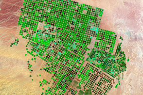
Crop Circles in the Desert Read more
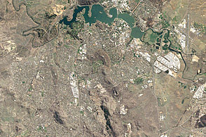
Changes in Canberra Read more
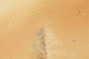
Empty Quarter, Arabian Peninsula Read more