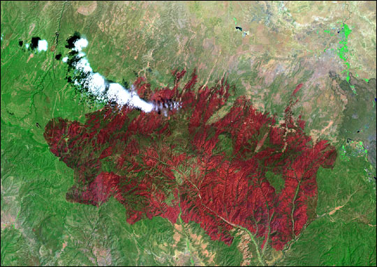
acquired July 7, 2002
Rodeo and Chediski Fires in Arizona
Downloads
- rodeo.L72002188_lrg.jpg (1298x920, JPEG)
Metadata
- Sensor(s):
- Landsat 7 - ETM+
- Data Date: July 7, 2002
- Visualization Date: July 7, 2002
This image from the Landsat Enhanced Thematic Mapper Plus (ETM+) shows the Rodeo-Chediski Fire on July 7, 2002. The result of two large fires that combined into a single blaze, the fire consumed almost half a million acres, and was the largest and most expensive fire in Arizona’s known history, costing more than $30 million before it was contained.
In this false-color image, vegetation appears bright green and burned areas are deep red. Landsat ETM+ captured the fires? succession over three weeks (see links below.)
June 21, 2002
June 29, 2002
Image provided by the USGS EROS Data Center Satellite Systems Branch.
This image record originally appeared on the Earth Observatory. Click here to view the full, original record.