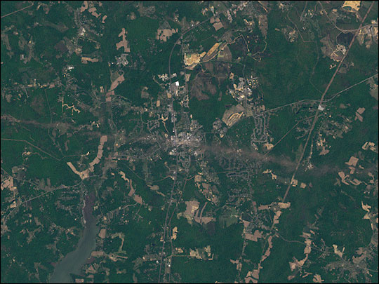
Tornado Hits La Plata, Maryland
Downloads
- l7_la_plata_20020501_lrg.jpg (4139x4139, JPEG)
Metadata
- Sensor(s):
- Landsat 7 - ETM+
- Data Date: May 1, 2002
- Visualization Date: May 3, 2002
Four days after Maryland’s strongest-ever tornado severely damaged the town of La Plata, authorities continued to count the cost of the storm. In the latest tally, 860 homes and 194 business were damaged or destroyed, and the total cost of the damage is expected to exceed $100 million.
The above image was acquired by the Enhanced Thematic Mapper plus (ETM+), aboard Landsat 7, one minute before Earth Observer-1 (which produced an image with the Advanced Land Imager (ALI) instrument) passed over La Plata on May 1, 2002. Although the ETM+ does not have quite the same resolution or sensitivity as the ALI (a maximum or 15 meters per pixel for the ETM+, and a maximum of 10 meters per pixel for the ALI), it has a much wider field-of-view. The scene shows the entire length of the tornado’s path—roughly 39 km (24 miles).
Image provided by the USGS EROS Data Center Satellite Systems Branch.
This image record originally appeared on the Earth Observatory. Click here to view the full, original record.