The Perry Fire by Day and Night
Downloads
- perry_oli_2018210_lrg.jpg (3734x3734, JPEG)
- perry_oli_2018210_night_lrg.jpg (3734x3734, JPEG)
Metadata
- Sensor(s):
- Landsat 8 - OLI
- Data Date: July 28, 2018
- Visualization Date: July 30, 2018
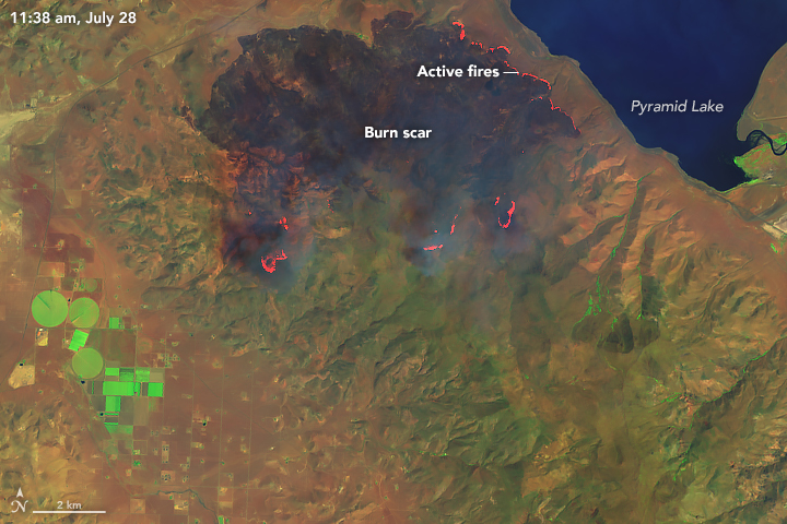
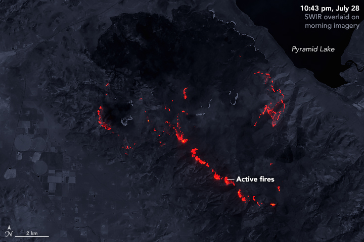
The Perry Fire was one of 98 large, active wildfires burning in the United States on July 30, 2018. While this fire north of Reno, Nevada, was not the largest or most destructive, the position of its smoke plume on July 29 allowed for a clear look at the burned area from space.
On that day, the Operational Land Imager (OLI) on Landsat 8 acquired these images of the fire. The images are based on observations of shortwave infrared and green light (bands 6-5-3). The brighter image was acquired at 11:38 a.m. local time. The darker image shows shortwave infrared light from the fire at night (10:43 p.m.). Notice how the front of the fire has moved toward the south and southeast.
As of the evening of July 29, the Perry Fire had burned about 25,600 acres and was 15 percent contained.
References and Related Reading
- InciWeb (2018, July 29) Perry Fire. Accessed July 30, 2018.
- NASA Earth Observatory (2018, July 30) Wildfires Blanket Western States With Smoke.
- NASA Earth Observatory (2018, July 21) County Fire Lights Up the Night.
- NASA Earth Observatory (2018, July 6) Fires in a Dry, Hot Colorado Summer.
- NASA Earth Observatory (2018, June 11) 416 Wildfire Rages in Colorado.
- Reno Gazette Journal (2018, July 29) UPDATE: Smoke stifling Reno is going to stick around all week. Accessed July 30, 2018.
NASA Earth Observatory images by Joshua Stevens, using Landsat data from the U.S. Geological Survey. Text by Kathryn Hansen.
This image record originally appeared on the Earth Observatory. Click here to view the full, original record.