One Year Adrift, but Not Far
Downloads
- a68_tir_2018182.jpg (720x594, JPEG)
- a68_tir_2017211_lrg.jpg (6378x9415, JPEG)
- a68_tir_2018182_lrg.jpg (6378x9415, JPEG)
Metadata
- Sensor(s):
- Landsat 8 - TIRS
- Data Date: July 30, 2017 - July 1, 2018
- Visualization Date: July 12, 2018
In July 2017, a huge iceberg dramatically broke away from the Larsen C Ice Shelf on the Antarctic Peninsula. But the aftermath has been a bit more drawn-out, as the berg hasn’t moved very far.
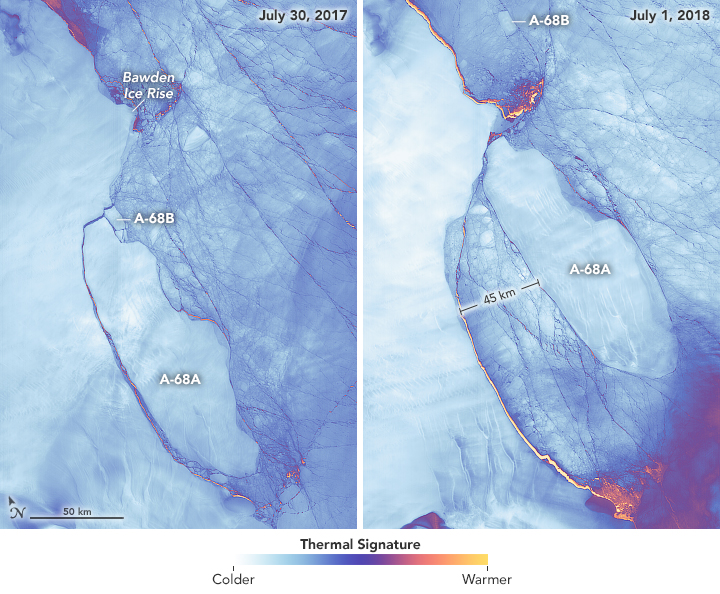
The left image shows Iceberg A-68 on July 30, 2017, soon after it broke away from the shelf and then fractured into two pieces known as A-68A and A-68B. The right image shows the same area on July 1, 2018. Both images are false-color, acquired with the Thermal Infrared Sensor (TIRS) on Landsat 8. Colors indicate the relative warmth or coolness of the landscape, from orange (warmest) to light blue and white (coldest).
In a year, iceberg A-68A moved a relatively short distance from the edge of the ice shelf into the Weddell Sea. In the right image, the berg’s western edge is roughly 45 kilometers from the shelf. A-68B, the much smaller fragment of the original berg, is more than twice that distance from its prior location.
A-68A’s sluggishness is not surprising. When it calved, the berg was about the size of Delaware and weighed more than a trillion tons. Dense sea ice in the Weddell Sea has made it harder for currents, tides, and winds to move all of that mass. The iceberg has also become stuck at times when its north end encounters the shallow water near Bawden Ice Rise, an ice-covered rock outcrop.
Still, Iceberg A-68A has seen plenty of motion. Throughout the year, tide cycles have shuffled the berg back and forth like a driver trying to get out of a tight parallel-parking spot. Its north end has been repeatedly smashed against Bawden Ice Rise, fracturing and reshaping its northern edge. Also notice how the southeastern edge appears to have grown in area. This is not part of the original iceberg; it is fast ice that has come fastened to the edge of the berg as it shoves through the ice pack.
A-68A will continue this dance in moonlight, as the darkness of austral winter continues through early August. Thermal images offer one way that scientists can “see” the iceberg during polar night. Radar imagery from the Sentinel-1 satellite also has been an important tool for Adrian Luckman and the UK-based Project MIDAS, which has been monitoring the iceberg and how its calving affects the Larsen C Ice Shelf.
There’s no telling how much longer A-68A will stay “stuck” in the Weddell Sea. The smaller A-68B is a good example of the path taken by many Antarctic bergs, as they are carried by currents out of the Weddell and northward toward South Georgia and the South Sandwich Islands.
References and Related Reading
- NASA Earth Observatory (2018, July) Rift and Calving at Larsen Ice Shelf.
- Project MIDAS (2018, July 9) Iceberg A68 one year on. Accessed July 13, 2018.
NASA Earth Observatory images by Joshua Stevens, using Landsat data from the U.S. Geological Survey. Story by Kathryn Hansen with image interpretation by Chris Shuman.
This image record originally appeared on the Earth Observatory. Click here to view the full, original record.