Flash Floods in Greece
Downloads
- mandra_mrg_2017320_lrg.png (2250x1500, PNG)
Metadata
- Sensor(s):
- Terra - ASTER
- Landsat 8 - OLI
- Data Date: November 16, 2017
- Visualization Date: November 16, 2017
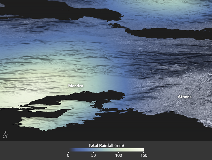
Late on November 14, 2017, a slow-moving weather system in the Mediterranean brought torrential rain and flash floods to Greece. Among the hardest hit places was Mandra, a town west of Athens. Floods there left hundreds of people homeless and claimed several lives.
This three-dimensional map shows satellite-based measurements of the rain that fell in the area from November 14 to 16. The data come from the Integrated Multi-Satellite Retrievals for GPM (IMERG), a product of the Global Precipitation Measurement mission. The precipitation data was draped over terrain data from the Advanced Spaceborne Thermal Emission and Reflection Radiometer (ASTER).
The GPM satellite is the core of a rainfall observatory that includes measurements from NASA, the Japan Aerospace Exploration Agency, and five other national and international partners. These rainfall totals are regional, remotely-sensed estimates, and local amounts can be significantly higher when measured from the ground.
References
- Greek Reporter (2017, November 16) Greece in Mourning Day after Flooding Disaster. Accessed November 16, 2017.
- Newsweek (2017, November 16) End of Days Arrive in Greek Town Destroyed by 'Biblical" Flooding. Accessed November 16, 2017.
- Euronews (2017, November 17) Drone footage shows devastation of floods in Greece. Accessed November 16, 2017.
- Reuters (2017, November 16) Greece — Deadly Floods in Attica Region. Accessed November 16, 2017.
NASA Earth Observatory image by Joshua Stevens, using IMERG data from the Global Precipitation Mission (GPM) at NASA/GSFC, Landsat data from the U.S. Geological Survey, and ASTER GDEM data from NASA/GSFC/METI/ERSDAC/JAROS, and U.S./Japan ASTER Science Team. Story by Adam Voiland.
This image record originally appeared on the Earth Observatory. Click here to view the full, original record.