A-68 Adrift
Downloads
- larsen_oli_2017259.jpg (720x545, JPEG)
- larsen_oli_2017259_lrg.jpg (3983x6293, JPEG)
- larsen_oli_2017259_thermal_lrg.jpg (3983x6293, JPEG)
- larsen_oli_2017259_detail.jpg (720x545, JPEG)
Metadata
- Sensor(s):
- Landsat 8 - OLI
- Landsat 8 - TIRS
- Data Date: September 16, 2017
- Visualization Date: September 29, 2017
A lot happened on the Antarctic Peninsula under the cloak of the 2017 polar night—most notably, the calving of a massive iceberg from the Larsen C ice shelf. At the time (July), scientists had to rely on thermal imagery and radar data to observe the break and to watch the subsequent motion of the ice.
By August, scientists started getting their first sunlit views of the new iceberg, which the U.S. National Ice Center named A-68. The Moderate Resolution Imaging Spectroradiometer (MODIS) on NASA’s Terra satellite captured a wide view of the berg on September 11. A few days later, on September 16, the Operational Land Imager (OLI) and the Thermal Infrared Sensor (TIRS) on Landsat 8 captured these detailed images.
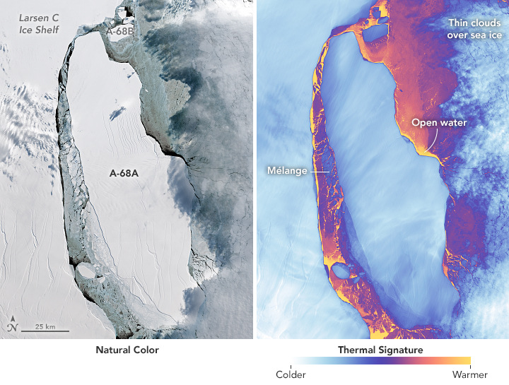
The image on the left shows the icebergs in natural color. The rifts on the main berg and ice shelf stand out, while clouds on the east side cast a shadow on the berg. The thermal image on the right shows the same area in false-color. Note that the clouds over the ice shelf do not show up as well in the thermal image because they are about the same temperature as the shelf. Thermal imagery has the advantage of showing where the colder ice ends and “warm” water of the Weddell Sea begins. It also indicates differences in the thickness of ice types. For example, the mélange is thicker (has a colder signal) than the frazil ice, but thinner (warmer signal) than the shelf and icebergs.
Both images show a thin layer of frazil ice, which does not offer much resistance as winds, tides, and currents try to move the massive iceberg away from the Larsen C ice shelf. In a few weeks of observations, scientists have seen the passage widen between the main iceberg and the front of the shelf. This slow widening comes after an initial back-and-forth movement in July broke the main berg into two large pieces, which the U.S. National Ice Center named A-68A and A-68B. The collisions also produced a handful of pieces too small to be named.

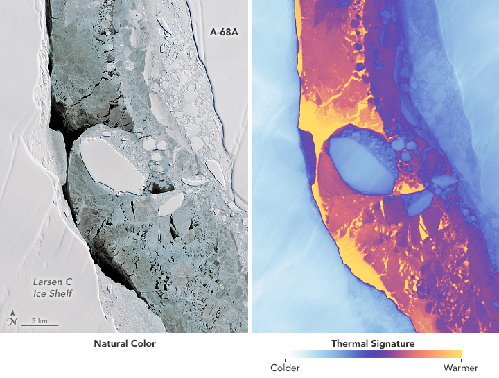
One unnamed iceberg, shown in detail above, has been drifting northward in the passage since the break. Notice how the edges of this piece appear much sharper than the edges of the shelf or A-68A. Those edges have already been rounded by blowing snow and gravity, but the smaller piece has been battered and reshaped by recent collisions, resulting in its highly defined edges.
References and Related Reading
- NASA Earth Observatory (2017) Rift and Calving at Larsen Ice Shelf.
NASA Earth Observatory images by Joshua Stevens using Landsat data from the U.S. Geological Survey. Story by Kathryn Hansen.
This image record originally appeared on the Earth Observatory. Click here to view the full, original record.