When Glaciers and Rivers Collide
Downloads
- khurdopin_oli_2017133_lrg.jpg (8000x8000, JPEG)
- khurdopin_oli_2017133_geo.tif (8000x8000, GeoTIFF)
- khurdopin_oli_2017133.jpg (720x540, JPEG)
- shimshal_2017may15_anwar.jpg (720x480, JPEG)
Metadata
- Sensor(s):
- Landsat 8 - OLI
- Data Date: May 13, 2017
- Visualization Date: August 1, 2017

For most alpine areas, scientists are concerned that global warming and retreating ice will swell glacial lakes and increase the risk of floods downstream. In the Karakoram Mountains of northern Pakistan, the remote Shimshal Valley has the same concern, but for a somewhat different reason.
Several of the glaciers that flow into this valley surge, meaning they cycle through periods when they flow forward several times faster than usual. Since the valley is narrow and has a river running through it, surging glaciers regularly dam the river and create flood hazards. The floods occur when water pooling up behind the tongue of the advancing glacier suddenly breaks through the natural ice dam and cascades down the gorge.
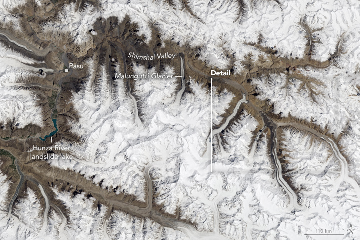
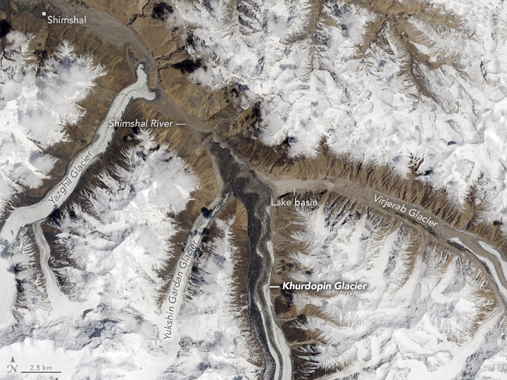
As seen in this Landsat 8 image, several glaciers flow into the Shimshal Valley perpendicular to the flow of the river, and they have little room to move before they intersect with the water. In recent decades, the four glaciers most prone to blocking the river have been the Khurdopin, Yukshin Gardan, Yazghil, and Malungutti. The Operational Land Imager (OLI) on Landsat 8 captured this image on May 13, 2017.

Of these, Khurdopin has surged most recently. After years of little movement, the glacier began a rapid advance in October 2016, accelerating to a rate of roughly 20 meters (65 feet) per day by the spring of 2017—one of the fastest rates observed for a glacier in this region. As ice and sediment pushed into the river, a sizable lake pooled up in March 2017. Jakob Steiner of Utrecht University and the Mountain Hydrology Group has been monitoring the growth of the lake using imagery collected by Landsat 8 and Planet Labs, a commercial satellite company.
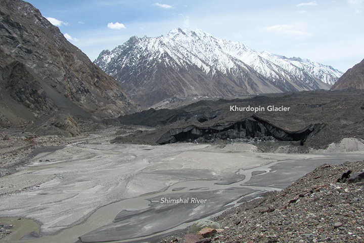
By July 2017, the river had carved an outlet through the glacial debris before the lake could grow extremely large, but Steiner’s group continued to keep a watchful eye on this area because of how much debris the glacier pushed into the river. The surge increased the thickness of the end of the glacier by as much as 80 meters (260 feet), according to Steiner. The photograph above, taken by Waheed Anwar of Focus Pakistan, shows the tip of the sediment-coated glacier pushing into the river on May 15, 2017. The camera is pointed upstream toward Khurdopin glacier.
The rapid draining of even a relatively small lake can have dramatic consequences downstream. In late July 2017, the size of the lake dropped from 100,000 square meters to about 40,000 square meters in a few days—a rapid enough change to produce a flood downstream that damaged bridges, farmland, and a key road. By August 3, 2017, the lake had completely drained. The flooding and road damage left hundreds of people stranded in the Shimshal Valley awaiting evacuation by helicopter, according to the The High Asia Herald.
Historical records show that surging glaciers have triggered at least 20 of these glacial lake outburst floods over the past century—making the valley one of the most vulnerable in the Karakoram. Past floods have caused damage with such frequency that villagers in the river towns of Pasu and Shimshal even established a beacon warning system. In the spring, more than 30 outposts were set up on visible hillsides along a 90-kilometer (60-mile) span of the gorge. When a flood occurred during the night, the outposts lit a series of bonfires to warn people downstream. During the day, they used the sound of gunfire to pass the message. The system has been replaced with cell phones, but the service is spotty enough in this valley that floods still sometimes take people by surprise.
Surging glaciers are not the only cause of flood hazards in this area. In the nearby Hunza River Valley in 2010, a massive landslide blocked the river and created a large lake. Though the lake now flows over the dam, the possibility that this natural dam could eventually breach elevates flood risks for towns and villages downstream of it.
References and Further Reading
- Dawn (2017, June 2) Mountains at Risk. Accessed August 7, 2017.
- Iturrizaga, L. (2005) New observations on present and prehistorical glacier-dammed lakes in the Shimshal valley (Karakoram Mountains. Journal of Asian Earth Sciences, 25 (4), 545-555.
- GeoConnexion (2016, June 1) Fifty people, two yaks and a goat. Accessed August 7, 2017.
- Pamir Times (2017, August 1) Shimshal River Flood: Bridge destroyed, road damaged, cultivable land affected at several places. Accessed August 7, 2017.
- Quincey, D.J. & Luckman, A. (2014) Brief Communication: On the magnitude and frequency of Khurdopin glacier surge events. The Cryosphere 8, 571-574.
- Steiner, J.F. et al. (2017) Brief Communication: The Khurdopin glacier surge revisited—extreme flow velocities and formation of a dammed lake in 2017. The Cryosphere.
- The High Asia Herald (2017, August 3)) Floods Cause Massive Destruction in GB. Hundreds stranded in valley, on roads. Accessed August 7, 2017.
- The High Asia Herald (2017, August 1) Floods continue to wreak havoc in Shimshal valley. Accessed August 7, 2017.
- UKClimbing (2016, March) The Karakoram Anomaly: Glacial Research in Pakistan. Accessed July 28, 2017.
NASA Earth Observatory images by Jesse Allen, using Landsat data from the U.S. Geological Survey. Story by Adam Voiland, with information and fact checking by Lasafam Iturrizaga (University of Göttingen) and Jakob Steiner (Utrecht University).
This image record originally appeared on the Earth Observatory. Click here to view the full, original record.