Easter Island
Downloads
- easterisland_oli_2015210_lrg.jpg (2000x2000, JPEG)
Metadata
- Sensor(s):
- Landsat 8 - OLI
- Data Date: July 29, 2015
- Visualization Date: April 13, 2017
This remote volcanic island has intrigued generations of scholars. Famed for its monolithic statues, Easter Island is shrouded in mystery. Its population—once sizable—collapsed.
“The clearest example of a society that destroyed itself by overexploiting its own resources,” is how University of California Los Angeles geographer Jared Diamond once described it. But the island’s history may not be as clear-cut as Diamond suggests. While scientists agree that broad-scale deforestation occurred here at some point, the verdict is still out on what exactly caused the downfall of the Rapanui people.
Scholars do agree on one thing: the island once looked very different than it does today. Called Rapa Nui by its original inhabitants, it takes its English name from the day Europeans arrived: April 5, 1722—Easter Sunday. Dutch navigator Jacob Roggeveen reported a few thousand people living there at the time. He described this island, more than 3,000 kilometers (2,000 miles) west of South America, as “exceedingly fruitful, producing bananas, potatoes, sugar-cane of remarkable thickness.”
Unbeknownst to Roggeveen, the indigenous population he encountered was just a fraction of its former size. Scholars estimate that between 15,000 to 20,000 people lived on Rapa Nui at the peak of its habitation. A thick cover of palm trees once shaded its hills, which are now fringed by low-lying vegetation.
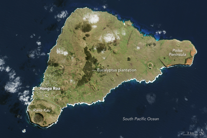
On July 29, 2015, the Operational Land Imager (OLI) on Landsat 8 captured this image of the island. The extinct Terevaka volcano dominates the landscape, which also includes Poike and Rano Kau volcanoes and a number of smaller volcanic features such as lava tubes. Tufts of clouds pepper the sky overhead and a thick white outline along the island’s southern edge indicates strong waves crashing against its shores. The Poike Peninsula, which juts out to the east, appears orange in places, a result of erosion exposing the brightly colored volcanic soil. The largest stand of trees, a eucalyptus plantation, was planted by people. Authorities hope reforestation efforts will help protect the island against the scouring wind.
About 5,000 people live on Easter Island today, and thousands of tourists come to see the anthropomorphic “moai” statues each year. Amid strain from a rising population, the island faces challenges ahead. It has no sewer system and continues to draw on a limited freshwater supply.
References and Related Reading
- American Scientist (2009) Rethinking the Fall of Easter Island. Accessed April 14, 2017.
- McGill University (2009) Easter Island. Accessed April 14, 2017.
- National Geographic (March 2017) Easter Island. Accessed April 14, 2017.
NASA Earth Observatory image by Jesse Allen, using Landsat data from the U.S. Geological Survey. Story by Pola Lem.
This image record originally appeared on the Earth Observatory. Click here to view the full, original record.