Fresh Water for Shanghai
Downloads
- shanghai_oli_2016202_lrg.jpg (4500x4500, JPEG)
- shanghai_tm5_1984114_lrg.jpg (4500x4500, JPEG)
Metadata
- Sensor(s):
- Landsat 8 - OLI
- Landsat 5 - TM
- Data Date:
- Visualization Date: April 10, 2017
Editor’s Note: The following story is based on our new feature World of Change: Sprawling Shanghai.
As Shanghai has spread out and rapidly industrialized over the past several decades, many of its waterways have become heavily polluted. Just 3 percent of the water in the city is clean enough to drink or use for aquaculture, one census of water resources found.
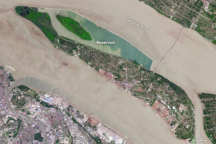
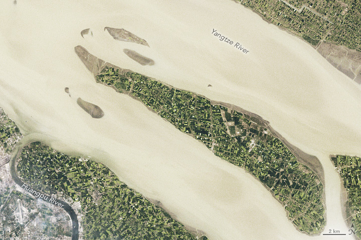
Meanwhile, Shanghai’s population has swollen to roughly 24 million people. To help meet the growing demand for fresh water, the city opened Qingcaosha Reservoir on Changxing Island in 2010. On July 20, 2016, the Operational Land Imager (OLI) on Landsat 8 captured this image of the reservoir. The second image shows the same area in 1984. The reservoir, which spans about 70 square kilometers (27 square miles) and has a capacity of 430 million cubic meters, supplies about 70 percent of Shanghai’s tap water.
Purer water within the reservoir appears blue; the more polluted, sediment-filled water of the Yangtze and the Huangpu rivers is brown. Qingcaosha’s water is drawn from deep within the middle of the Yangtze, which tends to be less polluted than the edges. The green wetlands in the northwestern portion of the reservoir help cleanse the water naturally, while serving as habitat for several types of birds and fish.
The water from Qingcaosha is significantly cleaner than water in the Yangtze or Huangpu. However, managers still contend with regular outbreaks of algae caused by high levels of phosphorus and nitrogen in the Yangtze. To help control the algae, the Shanghai Municipal Water Authority recently released large numbers of chub and carp into the reservoir, according to Shanghai Daily.
Qingcaosha is closely guarded by police. Though officers use helicopters, speedboats, and foot patrols to monitor for intruders, they regularly catch people fishing there illegally, according to China Daily.
References and Further Reading
- China Daily (2011, May 26) New reservoir to keep Shanghai in fresh water. Accessed April 6, 2017.
- China Daily USA (2013, September 27) Police protect essential drinking water supply. Accessed April 6, 2017.
- Popular Science (2017, March 25) 16,000 Dead Pigs In The Huangpu: Can You Still Drink Shanghai’s Water? Accessed April 6, 2017.
- Shanghai Daily (2017, March 14) Fish in troubled waters fight decay. Accessed April 6, 2017.
- Shanghai (2013, August 9) Half of Shanghai’s rivers and lakes heavily polluted. Accessed April 6, 2017.
- Travel China Guide Drinking Water in China. Accessed April 6, 2017.
- Taihe (2013, May) Qingcaosha Water Source, Shanghai. Accessed April 6, 2017.
NASA Earth Observatory images by Joshua Stevens and Jesse Allen, using Landsat data from the U.S. Geological Survey. Caption by Adam Voiland.
This image record originally appeared on the Earth Observatory. Click here to view the full, original record.