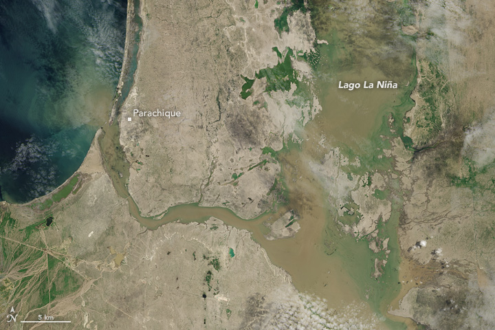
acquired April 4, 2017
Flooding in Northern Peru
Downloads
- peru_oli_2017094_lrg.jpg (5604x8406, JPEG)
- peru_oli_2017094_geo.tif (5604x8406, GeoTIFF)
Metadata
- Sensor(s):
- Landsat 8 - OLI
- Data Date: April 4, 2017
- Visualization Date: April 7, 2017
Several weeks of intense rain have triggered severe floods and mudslides in Peru. On April 4, 2017, the Operational Land Imager (OLI) on Landsat 8 captured this image of flood waters near the town of Parachique. More than 180,000 houses throughout the country have been flooded, according to Lutheran World Relief.
References and Further Reading
- European Commission (2017, March 28) Floods in Peru. Accessed April 7, 2017.
- Inside Climate News (2017, April 6) Peru’s Floods Follow Climate Change’s Deadly Extreme Weather Trend. Accessed April 7, 2017.
- Lutheran World Relief (2017, March 30) Peru Flooding and Mudslides. Accessed April 7, 2017.
- Monitoring of the Andean Amazon Project (2017, March 30) Major Flooding in Northern Peru from Coastal El Niño. Accessed April 7, 2017.
- NASA Earth Observatory (2017, March 23) Flood Waters Inundate Coastal Peru.
NASA Earth Observatory image by Jesse Allen, using Landsat data from the U.S. Geological Survey. Caption by Adam Voiland.
This image record originally appeared on the Earth Observatory. Click here to view the full, original record.