
Lava Delta Collapses into Sea
Downloads
- kilauea_oli_2017003_lrg.jpg (3000x2000, JPEG)
- kilauea_oli_2015286_lrg.jpg (3000x2000, JPEG)
Metadata
- Sensor(s):
- Landsat 8 - OLI
- Data Date: October 13, 2015 - January 3, 2017
- Visualization Date: January 6, 2017
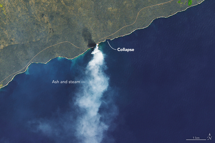
Around 2:45 p.m. local time on December 31, 2016, unstable volcanic terrain began to tumble into the sea at Kamokuna, an area where lava from Hawaii’s Kilauea volcano pours into the sea. Fiery explosions, large waves, and a towering plume of steam and ash sprang forth as the lava delta and older nearby sea cliffs crumbled away.
Lava deltas are fan-shaped patches of new land that form along coasts when lava flows directly into the ocean. When they are built on steep marine slopes, they can easily collapse.
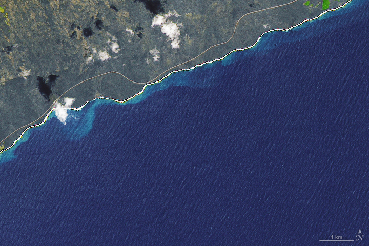
On January 3, 2017, the Operational Land Imager (OLI) on Landsat 8 captured an image showing the aftermath of the collapse. For comparison, the second image shows the same area on October 13, 2015. Almost all of the Kamokuna lava delta is now gone. The collapsed portion of the sea cliff extended about 180 meters (590 feet) east of the delta edge, and cut inland about 70 meters (230 feet) from the shoreline. (The U.S. Geological Survey has posted a detailed map showing both of these areas.) In the 2017 image, a plume of steam and volcanic gases is rising from waters west of the collapse, in an area where lava continues to flow into the sea.
The event brought a brush with death for five onlookers who violated park ranger warnings and were nearly swept away by the collapsing sea cliff. With so much cliff gone, the National Park Service has opened a new viewing location at a safer distance.
References
- Big Island Video News (2017, January 4) USGS Scientist Describes Lava Delta Collapse. Accessed January 6, 2017.
- Khon2 (2017, January 2) Lava flow viewing area collapses into ocean.Accessed January 6, 2017.
- LiveScience (2017, January 4) Huge Lava Collapse Rings in Hawaii’s New Year. Accessed January 6, 2017.
- USGS Hawaiian Volcano Observatory (2017, January 3) Photos & Video Chronology: Ongoing activity at Kamokuna ocean entry. Accessed January 6, 2017.
- USGS Hawaiian Volcano Observatory (2017, January 3) Recent Kilauea Status Reports, Updates, and Information Releases. Accessed January 6, 2017.
- USGS Hawaiian Volcano Observatory (2017, January 6) Updated Kamokuna ocean entry map. Accessed January 6, 2017.
- USGS Hawaiian Volcano Observatory (2004, September 27) When Lava Enters the Sea: Growth & Collapse of Lava Deltas. Accessed January 6, 2017.
NASA Earth Observatory images by Joshua Stevens, using Landsat data from the U.S. Geological Survey. Caption by Adam Voiland.
This image record originally appeared on the Earth Observatory. Click here to view the full, original record.