Oil Fires in Iraq
Downloads
- iraq_oli_2016230.jpg (720x480, JPEG)
- iraq_oli_2016230_lrg.jpg (5886x3924, JPEG)
Metadata
- Sensor(s):
- Landsat 8 - OLI
- Data Date: May 29, 2016 - August 17, 2016
- Visualization Date: August 30, 2016
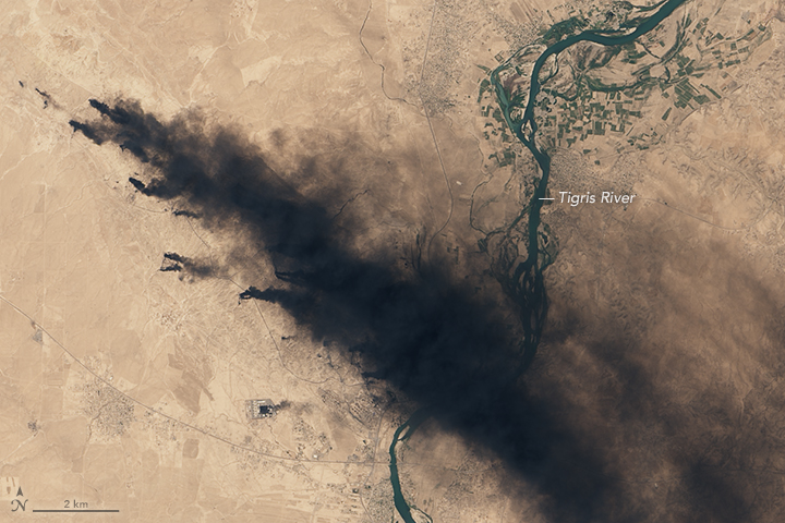
For the past few months, a smoke plume has shifted with the winds over northern Iraq. In recent years, periodic oil fires have cast a dark pall over this arid landscape. They are one consequence of ongoing war in the region.
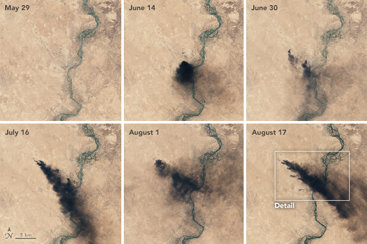
On August 17, 2016, the Operational Land Imager (OLI) on Landsat 8 acquired an image (above) of dense smoke plumes roughly 50 kilometers (30 miles) south of Mosul. There appear to be multiple sources of fire, most likely oil wells from the Qayyarah oil field. The images in the grid below show the plumes changing direction and thickness since they were first spotted by Landsat 8 on June 14.
The current smoke event recalls fires in neighboring Kuwait during the 1990s Persian Gulf War. Iraqi troops ignited more than 700 oil wells during that conflict.
Ronald Ferek of the U.S. Office of Naval Research saw those fires firsthand in June 1991. “We flew across whole plumes and did a cross-section, calculating how many barrels had to be burning,” he said. His team used LIDAR to quantify carbon flux and deduce the carbon dioxide emitted. The fires consumed roughly 4.6 million barrels of oil a day, according to their estimates.
At the time, some scientists warned of dire effects, including a “nuclear winter” cooling effect at Earth’s surface. Some airborne smoke particles can reflect sunlight, driving down temperatures on the ground. Following the theory, particles in the oil smoke would rise into the stratosphere and stay aloft for weeks or months over the Northern Hemisphere.
But most of the fires in Kuwait did not spill over and burn in pools standing on the ground, as predicted. Instead, they caught fire in the air, Ferek said, when oil shot out of the ground at high pressures.
“At 15,000 PSI (pounds per square inch), oil comes out like an aerosol spray can rather than a garden hose,” he said. As result, the flames were bathed in oxygen and burned more cleanly than earlier research had indicated they would.
Like the current fires in Iraq, many of Kuwait’s fires produced thick, dark smoke. The plume color is dependent on the type of fuel burning. Factors like humidity, wind, and fuel density also affect the smoke’s color, said Ralph Kahn, an atmospheric scientist at NASA’s Goddard Space Flight Center. Kuwait’s natural gas fires, many of which burned alongside oil fires, produced grayish white smoke palls, due in part to the high salt content from the briny substrate there.
As with biomass burning, a critical factor in oil fires is the ratio between flaming to smoldering. Oxygen-starved, smoldering fires (such as those burning in peatlands) produce large amounts of smoke and particulate matter. Meanwhile, flames that are well-supplied with oxygen can burn more efficiently, breaking down much of the matter and producing more black smoke.
References and Related Reading
- Albawaba (August 31, 2016) Oil Fires Burn Across Qayyara After Iraqi Army Retakes City from Daesh. Accessed August 31, 2016.
- Ferek, R. J., et al (September 20, 1992) Chemical Composition of Emissions from the Kuwait Oil Fires. Journal of Geophysical Research, 97 (D13), 14483–14489. DOI: 10.1029/92JD01247
- Forbes (September 25, 2005) Why Islamic State’s (ISIS) Oil Revenue is Plunging. Accessed August 31, 2016.
- National Geographic (August 1991) The Persian Gulf: After the Storm. Accessed August 30, 2016.
- NASA Gateway to Astronaut Photography of Earth (April 7, 1991) Oil Fires and Smoke, Kuwait, April 1991.
- NASA Earth Observatory (August 13, 2003) Oil Smoke in Northern Iraq.
NASA Earth Observatory images by Joshua Stevens, using Landsat data from the U.S. Geological Survey. Caption by Pola Lem.
This image record originally appeared on the Earth Observatory. Click here to view the full, original record.
