On the Lookout
Downloads
- capelookout_oli_2016049_lrg.jpg (5000x5000, JPEG)
- capelookout_oli_2016049_geo.tif (5000x5000, GeoTIFF)
Metadata
- Sensor(s):
- Landsat 8 - OLI
- Data Date: February 18, 2016
- Visualization Date: March 4, 2016
On a map created in 1590, the area was labeled Promontorium tremendum: horrible headland, or cape terrible. Four centuries later, these barrier islands along the North Carolina coast are better known as havens for turtles and wild horses and for humans seeking a bit of tranquility by the sea.
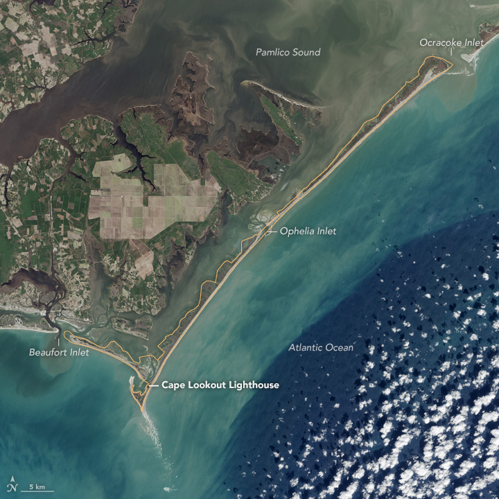
Cape Lookout National Seashore stretches 56 miles (90 kilometers) from Okracoke Inlet to Beaufort Inlet, near the towns of Beaufort and Morehead City. The park is made of three barrier islands—North Core Banks, South Core Banks, and Shackleford Banks—that separate the Atlantic Ocean from Pamlico Sound and extensive marshlands. There are no bridges or roads to the islands; the only way to get there is by ferry or private boat.
Above the water line, the islands are mostly low dunes, wide sandy beaches, and some coastal grasses and trees. Below the water surface, the infamous shoals, converging currents, and natural sand movement around barrier islands make for a dynamic environment that remains a danger to ships.
On February 18, 2016, the Operational Land Imager (OLI) on the Landsat 8 satellite acquired this image of Cape Lookout National Park. Note how the swirling sediments and shallow bottoms appear as faint green, tan, and blue areas around the islands. The yellow line around the islands notes the official boundaries of the park.
“It is striking how narrow the barrier islands are, and yet they do such an important job for the developed areas of the mainland,” said Karen Duggan, a park ranger at Cape Lookout National Seashore. “I really like being able to see the shoals: from the long, Cape Lookout Shoal sticking out into the ocean to the smaller, erosional shoal coming off the eastern end of Shackleford Banks. You can really tell that it is trying to close off Bardens Inlet between the lighthouse and Shackleford Bank.”
Those infamous shallows led the U.S. government to build a wood-frame, 96-foot tall lighthouse at the southern tip of the islands in 1812. With many a vessel still having trouble in these waters, the U.S. Lighthouse Board authorized construction of a much taller (163 foot or 50 meter) brick lighthouse in 1859. That structure still stands today, having survived the Civil War and World War II. Visitors to the park can climb the 207 steps from ground level to the light.
At the north end of the park, near Ocracoke Inlet, the historic village of Portsmouth still attracts visitors. In years past, the village served as a “lightering” port; that is, heavy, ocean-going ships would stop in Portsmouth to unload their cargo into smaller ships that could navigate the shallower sounds and waterways between the barrier islands and the mainland.
Cape Lookout has in recent decades become a haven for loggerhead sea turtles, a threatened species that nests on the islands. More than 275 species of birds can be spotted in the area, and one of the islands—Shackleford Banks—is home to a herd of feral horses that are rumored to be descendants of Spanish mustangs that survived shipwrecks in the area.
Cape Lookout National Seashore was first authorized on March 10, 1966, and celebrates its 50th anniversary this week.
Related Reading
- National Park Service (2016) Cape Lookout National Seashore. Accessed March 6, 2016.
- Blogspot: Coastal North Carolina (2013) Promontorium Tremendum. Accessed March 6, 2016.
- North Carolina Maritime Museums (2012) Cape Lookout Studies Program. Accessed March 6, 2016.
- Wikipedia (2016) Cape Lookout National Seashore. Accessed March 6, 2016.
NASA Earth Observatory image by Jesse Allen, using Landsat data from the U.S. Geological Survey. Caption by Mike Carlowicz.
This image record originally appeared on the Earth Observatory. Click here to view the full, original record.