
Flooding Near Columbia, South Carolina
Downloads
- southcarolina_ali_2015281_lrg.jpg (1600x1600, JPEG)
- southcarolina_oli_2014288_lrg.jpg (1600x1600, JPEG)
Metadata
- Sensor(s):
- EO-1 - ALI
- Landsat 8 - OLI
- Data Date: October 0, 2014 - October 0, 2015
- Visualization Date: October 9, 2015
After record-breaking rains pounded South Carolina in early October 2015, severe floods overwhelmed many parts of the state. More than a dozen dams were breached, entire neighborhoods were swamped, hundreds of roads were made impassable, and more than a dozen people were killed .
More than a week after rain stopped falling, residents of low-lying coastal communities found themselves bracing for a second deluge as flood waters from inland worked toward the sea. On October 8, 2015, meteorologists warned that Georgetown, Jamestown, and points south of Givhans Ferry could face severe flooding in the coming days.
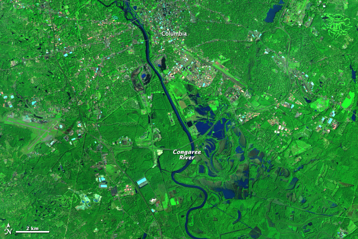
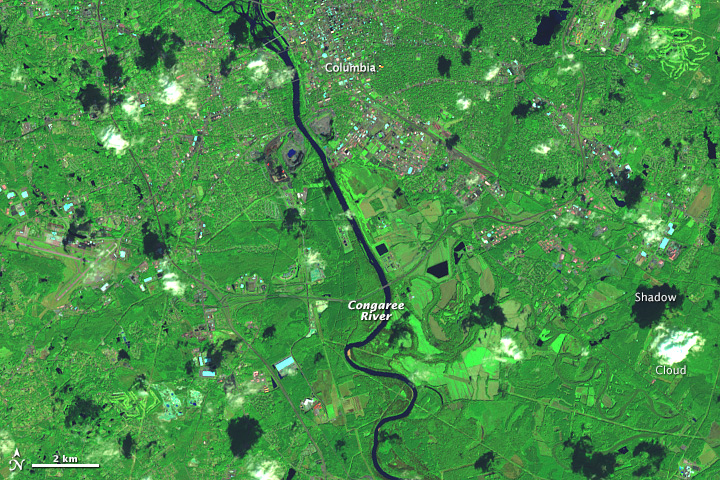
On October 8, 2015, the Advanced Land Imager (ALI) on NASA’s Earth Observing-1 (EO-1) satellite observed the flooded interior of South Carolina. For comparison, the second image shows the same area on October 15, 2014, as observed by the Operational Land Imager (OLI) on Landsat 8. Flood water covered broad swaths of farmland, forests, and wetlands east of the Congaree River in 2015. Note that the dark areas in the 2014 image are cloud shadows.
Columbia set new records for 24-hour, two-day, and three-day rainfall totals as a result of the rain. Meteorologists tracking the event say it was severe enough to be categorized as a “1000-year rain”—meaning there is just a 0.1 percent chance that a rain event so severe can occur in any given year.
References
- CNBC (2015, October 5) ‘1,000-year’ flood: Weather hyperbole or hard science? Accessed October 9, 2015.
- Live 5 News (2015, October 6) Georgetown Co. will see flooding in next 12 hours. Accessed October 9, 2015.
- National Weather Service (2015, October 6) Preliminary Storm Total Rainfall Amounts. Accessed October 9, 2015.
- National Weather Service Advanced Hydrologic Prediction Service (2015, October 6) River Observations. Accessed October 9, 2015.
- The Washington Post (2015, October 5) The meteorology behind South Carolina’s catastrophic, 1,000-year rainfall event. Accessed October 9, 2015.
- The Washington Post (2015, October 8) Sobering before and after pictures show extent of South Carolina flooding. Accessed October 9, 2015.
NASA Earth Observatory image by Jesse Allen, using EO-1 ALI data provided courtesy of the NASA EO-1 team and Landsat data from the U.S. Geological Survey. Caption by Adam Voiland.
This image record originally appeared on the Earth Observatory. Click here to view the full, original record.