
Kuh-e-Gugerd
Downloads
- qom_oli_2015226_lrg.jpg (7600x7600, JPEG)
- qom_oli_2015226_wide.jpg (720x480, JPEG)
Metadata
- Sensor(s):
- Landsat 8 - OLI
- Data Date: August 14, 2015
- Visualization Date: September 25, 2015
Editor’s Note: Today’s caption is the answer to Earth Observatory’s September 2015 puzzler.
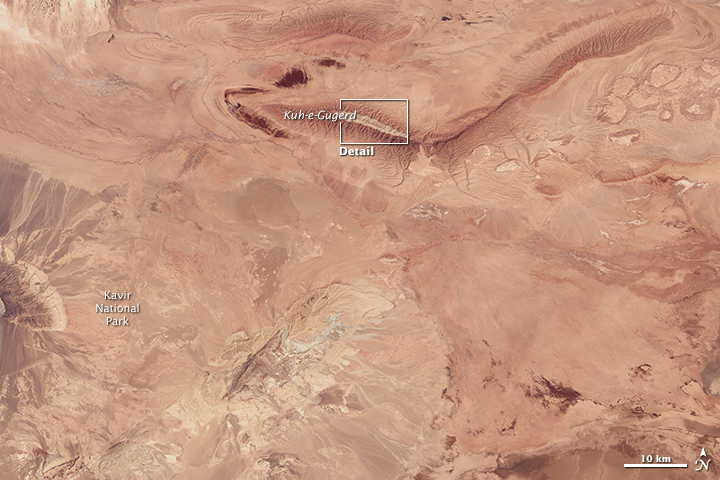
Iran’s Dasht-e Kavir (Great Salt Desert) is lined by the Alborz Mountains to the north and the Zagros Mountains to the south. The desert has not been immune to the great tectonic forces that raised up the Alborz. The relatively flat landscape occasionally gives way to small, elongated mountains.
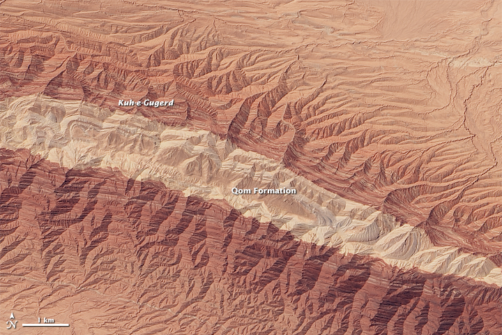
One such mountain is Kuh-e-Gugerd (Kuh-e-Gugird), which rises about 600 meters (2,000 feet) above the desert plain. The Operational Land Imager (OLI) on Landsat 8 captured this view of the mountain on August 14, 2015.
Kuh-e-Gugerd means “mountain of sulfur,” according to Martin Jackson, a geologist at the University of Texas at Austin. “The name is probably related to the gypsum (hydrous calcium sulfate) known to be there.” Indeed, gypsum is present in some of the rocks visible at higher elevations (light brown in the image). But there is more in the mix: limestone, marl, and minor shale also contribute to what is known as the Qom Formation—marine sediment that was deposited in Iran tens of millions of years ago, during the Oligocene and early Miocene epochs.
The Qom Formation is also the oldest part of the mountain in this image. That’s because the mountain is an anticline: rock that has been folded and then slopes away from the crest. The folding and subsequent erosion has exposed the oldest and once-deepest rocks of the mountain’s core, which appears almost white in this image.
The dark-brown areas at lower elevations are younger. These sediments, which consist primarily of mud rocks and evaporites (pale streaks), were initially shed from the rising Alborz Mountains about 60 kilometers (40 miles) to the north.
Mountains are not the only striking features of central Iran’s desert landscape. Just east of this image, about 50 salt domes and the sediments surrounding them have been folded and shaped into striking patterns that are visible in imagery from satellites and from astronauts on the International Space Station.
References and Related Reading
- Bouzari, S. et al. (2013, January 30) Thin-skinned tectonics in the Central Basin of the Iranian Plateau in the Semnan area, Central Iran. Journal of Asian Earth Sciences, 62 (2013), 269–281.
- Jackson, M.P.A. et al. (1990) Salt Diapirs of the Great Kavir, Central Iran. GSA Memoirs, 177 (1990), 1–150.
- Morley, C. K. et al. (2009) Structural development of a major late Cenozoic basin and transpressional belt in central Iran: The Central Basin in the Qom-Saveh area. Geosphere, 5 (4), 325–362.
- NASA Earth Observatory (2014, March 31) Kavir Desert, Iran.
- NASA Earth Observatory (2013, February 17) Iran’s Great Salt Desert.
- NASA Earth Observatory (2005, August 7) Kavir National Park, Iran.
NASA Earth Observatory images by Joshua Stevens, using Landsat data from the U.S. Geological Survey. Caption by Kathryn Hansen.
This image record originally appeared on the Earth Observatory. Click here to view the full, original record.