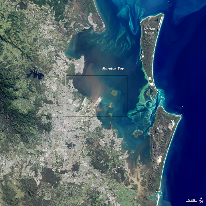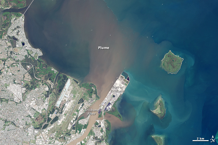

Plume in Moreton Bay, Australia
Downloads
- moretonbay_oli_2015123_wide.jpg (720x720, JPEG)
- moretonbay_oli_2015123_lrg.jpg (6000x6000, JPEG)
- moretonbay_oli_2015123_geo.tif (6000x6000, GeoTIFF)
- moreton_oil_2015123.kml (KML)
Metadata
- Sensor(s):
- Landsat 8 - OLI
- Data Date: May 3, 2015
- Visualization Date: May 5, 2015
For the second time in as many weeks, the east coast of Australia was hit by a severe storm and deadly flooding. According to news reports, a storm on May 1, 2015, dropped more than 360 millimeters (14 inches) of rain within about three hours in southeast Queensland. As a result of the rainfall, flash flooding caused distinct river plumes to form along the coastline.
On May 3, after the storm had passed, the Operational Land Imager (OLI) on Landsat 8 acquired this view of a plume from the Brisbane River entering Moreton Bay. The second image shows a close-up view of the area.
Flood waters usually contain elevated levels of sediment and colored dissolved organic matter (CDOM), explained NASA ocean color scientist Lachlan McKinna. Sediment tends to scatter red light, and CDOM absorbs blue light. As a result, a brown color is visible at the river’s mouth where these two optical phenomena work in concert.
“However, as you move farther away from the river mouth, the coarser sediments tend to settle to the bottom but the CDOM still hangs around in the water column absorbing blue light,“ McKinna said. “I expect it is elevated levels of CDOM causing the yellow-green patches in Moreton Bay.”
The May storm followed a disturbance that brought destructive winds and floods to New South Wales from April 20–22. And Australia’s west coast did not go unscathed, as rainfall from tropical cyclone Quang drenched the region.
Watch this animation, based on data from the Integrated Multi-satellite Retrievals for GPM (IMERG), to see rainfall accumulate around the Australian coast from April 28 to May 3.
References and Related Reading
- Australian Government Bureau of Meteorology (2015, May 1) Northern NSW to feel the brunt of East Coast Low Overnight. Accessed May 5, 2015.
- NASA Earth Observatory (2015, April 21) Storm Hits New South Wales, Australia.
- Precipitation Measurement Missions (2015, May 4) NASA IMERG Sees Australia’s Bicoastal Rainfall. Accessed May 5, 2015.
- Reuters (2015, May 2) Flash floods kill five as torrential rains hit Australia’s east coast. Accessed May 5, 2015.
NASA Earth Observatory image by Jesse Allen, using Landsat data from the U.S. Geological Survey. Caption by Kathryn Hansen.
This image record originally appeared on the Earth Observatory. Click here to view the full, original record.