Wildfires near Chile’s Llaima Volcano
Downloads
- lliama_oli_2015076_lrg.jpg (4508x3005, JPEG)
- lliama_oli_2015076_lrg.jpg (4508x3005, JPEG)
- llaima_oli_2015076.kml (KML)
Metadata
- Sensor(s):
- Landsat 8 - OLI
- Data Date: March 17, 2015
- Visualization Date: March 24, 2015
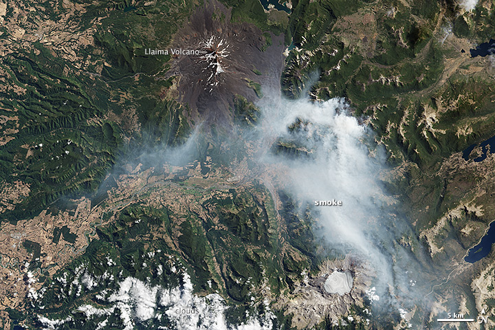
High winds and unusually warm weather are fueling damaging wildfires in southern Chile. The Operational Land Imager (OLI) on Landsat 8 acquired this image of smoke produced by a fire southeast of Llaima volcano on March 17, 2015. Fires have burned thousands of hectares of the China Muerta and Nalca Lolco reserve, as well as the Conguillio National Park, according to media reports. The Moderate Resolution Imaging Spectroradiometers (MODIS) on NASA’s Terra and Aqua satellites have acquired several images of the fires as well.
References
- Phys.org (2015, March 22) Chile wildfires damage unique flora, fauna. Accessed March 24, 2015.
- Reuters (2015, March 24) Forest fires rage in Chile, made worse by strong winds, drought. Accessed March 24, 2015.
- Press TV (2015, March 24) Chile wildfires prompt officials to declare red alert for three national parks. Accessed March 24, 2015.
NASA Earth Observatory image by Jesse Allen, using Landsat data from the U.S. Geological Survey. Caption by Adam Voiland.
This image record originally appeared on the Earth Observatory. Click here to view the full, original record.