Elephant Foot Glacier
Downloads
- elephantfoot_oli_2014172_lrg.jpg (2000x2000, JPEG)
- elephantfoot_oli_2014172_geo.tif (2000x2000, GeoTIFF)
- arcticlongswath_oli_2014172.kml (KML)
Metadata
- Sensor(s):
- Landsat 8 - OLI
- Data Date: June 21, 2014
- Visualization Date: February 12, 2015
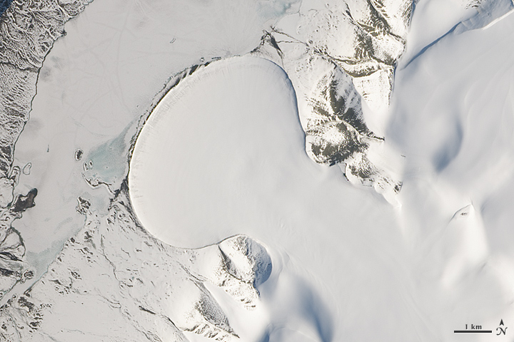
Pour batter onto a griddle and watch the mixture spread out into a round-shaped pancake. The movement is similar to the flow of piedmont glaciers, which form when ice spills from a steep valley onto a relatively flat plain. These glaciers are known for their nearly symmetric, fan-shaped lobes.
The shape of Greenland’s Elephant Foot Glacier, for example, is so distinct that it stands out dramatically from its surroundings when viewed from space. The Operational Land Imager (OLI) on Landsat 8 acquired this image of the glacier on June 21, 2014.
“Elephant Foot is an excellent example of a piedmont glacier,” said NASA scientist Tom Neumann. “In fact, it is often used as the example of a piedmont glacier because it is so symmetric.”
Located in northeastern Greenland on the Kronprins Christian Land peninsula, the glacier is not connected to Greenland’s main ice sheet. Rather, it’s part of a network of glaciers and ice caps that pepper the periphery of the island. Research has shown that as a whole, these outlying glaciers and ice caps account for 5 to 7 percent of Greenland’s total ice coverage, but they are responsible for 20 percent of its contribution to sea level rise.
Elephant Foot Glacier is just one of the beautiful scenes contained within an image swath acquired from across the Arctic by Landsat 8. To interactively explore the entire swath and to view more image highlights, read the full story here.
References and Related Reading
- Bolch, T. et al. (2013, March 13) Mass loss of Greenland’s glaciers and ice caps 2003-2008 revealed from ICESat laser altimetry data. Geophysical Research Letters, 40, 875-881.
- Livescience (2013, March 19) Greenland’s Isolated Glaciers Melting Quickly. Accessed February 19, 2015.
- NASA Earth Observatory (2014, February 16) Landsat Goes Over the Top: A Long View of the Arctic.
- National Snow and Ice Data Center (2014) Glacier Types: Piedmont. Accessed February 19, 2015.
NASA Earth Observatory image by Jesse Allen, using Landsat data from the U.S. Geological Survey. Caption by Kathryn Hansen.
This image record originally appeared on the Earth Observatory. Click here to view the full, original record.