Ashfall on Zhupanovsky Volcano
Downloads
- zhupanovksy_oli_2014335.jpg (720x480, JPEG)
- zhupanovksy_oli_2014335_lrg.jpg (5660x5660, JPEG)
- zhupanovksy_oli_2014335_geo.tif (GeoTIFF)
Metadata
- Sensor(s):
- Landsat 8 - OLI
- Data Date: December 1, 2014
- Visualization Date: December 2, 2014
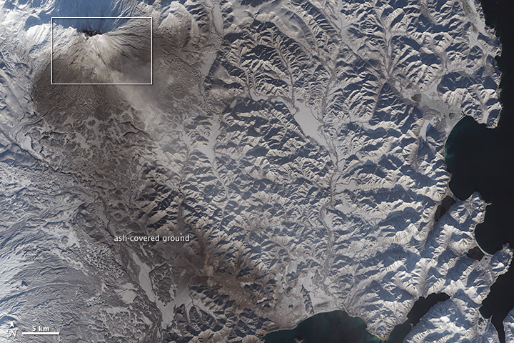
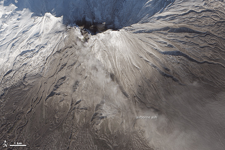
The ongoing eruption at Zhupanovsky volcano has left its mark on the mountain’s slopes. Ash—in the air and on the snow—is visible in these images acquired on December 1, 2014, by the Operational Land Imager (OLI) on Landsat 8. The top image provides a broad view of ash blanketing the snow-covered mountainside, while the bottom image provides a close-up of airborne ash near the top of the caldera.
Zhupanovksy, located on Russia’s Kamchatka Peninsula, began erupting on June 6, 2014. November 2014 began with a strong explosive event at the volcano, which tapered into a series of moderate explosive events toward the end of the month. According to the Global Volcanism Program, the explosions at Zhupanovksy are phreatic, caused by the nearly instantaneous vaporization of water by hot material below the surface.
References and Further Reading
- KVERT, Institute of Volcanology and Seismology (2014, November 8) Kamchatka and the Northern Kuriles volcanoes: Erupting or Restless. Accessed December 2, 2014.
- Smithsonian Institution Global Volcanism Program (2014) Zhupanovsky. Accessed December 2, 2014.
- NASA Earth Observatory (2014, September 25) Volcanoes of Kamchatka. Accessed December 2, 2014.
- NASA Earth Observatory (2013, November 5) Steam Explosions at Zhupanovsky Volcano. Accessed December 2, 2014.
NASA Earth Observatory image by Jesse Allen, using Landsat data from the U.S. Geological Survey. Caption by Kathryn Hansen.
This image record originally appeared on the Earth Observatory. Click here to view the full, original record.