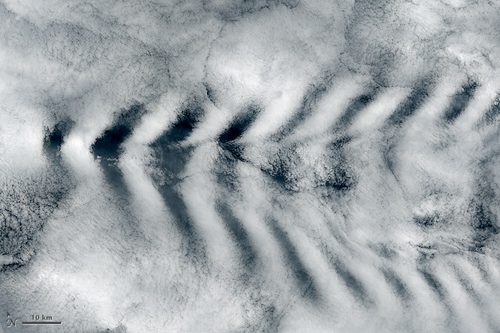
Wave Clouds behind Amsterdam Island
Downloads
- amsterdam_oli_2014306_lrg.jpg (8573x5715, JPEG)
Metadata
- Sensor(s):
- Landsat 8 - OLI
- Data Date: November 2, 2014
- Visualization Date: November 26, 2014
More than 3,000 kilometers (2,000 miles) from any continent, Amsterdam Island pokes out from the southern Indian Ocean at a point between Africa, Australia, and Antarctica. The product of a basaltic volcano that was last active about 200,000 to 400,000 years ago, the tiny elliptical island reaches an elevation of 867 meters (2,844 feet) at its highest peak.
As shown by this natural-color satellite image, that peak was high enough to disrupt the clouds flowing around it. The image was acquired by the Operational Land Imager (OLI) on Landsat 8 on November 2, 2014. It features mountain-wave clouds flowing in a southeasterly direction on the lee side of Amsterdam Island. Part of the island is visible on the far left of the image. Note that the image has been rotated slightly.
Wave clouds can form when stable air flows over a raised land form. In this case, the island generated wave motions in the air passing over it, much like the bow of a ship creates ripples as it cuts through water. The crests of these waves raised and cooled the air enough to form clouds, while the troughs remain too low and warm for cloud formation. The result was this distinctive pattern in the clouds.
See more images of islands creating wave clouds here and here.
References
- American Meteorological Society Mountain Wave. Accessed November 28, 2014.
- Global Volcanism Program Amsterdam Island. Accessed November 28, 2014.
- Weather Almanac Topping the Mountains. Accessed November 28, 2014.
NASA Earth Observatory image by Jesse Allen, using Landsat data from the U.S. Geological Survey. Caption by Adam Voiland.
This image record originally appeared on the Earth Observatory. Click here to view the full, original record.