A Thousand Miles from Nowhere
Downloads
- bouvetisland_oli_2013147_lrg.jpg (2000x2000, JPEG)
- bouvetisland_oli_2013147_geo.tif (GeoTIFF)
- bouvetisland_oli_2013147.kml (KML)
Metadata
- Sensor(s):
- Landsat 8 - OLI
- Data Date: May 26, 2013
- Visualization Date: February 25, 2014
There is perhaps no better place to get away from it all than Norway’s Bouvet Island. Located in the South Atlantic Ocean between Africa, South America, and Antarctica, this uninhabited, 49-square-kilometer (19-square-mile) shield volcano is one of the most remote islands in the world. The nearest large land mass is the Princess Astrid Coast of Queen Maud Land, Antarctica—1,700 kilometers (1,100 miles) to the south. The nearest inhabited place is Tristan da Cunha, a remote island 2,260 kilometers (1,400 miles) to the northwest that is home to a few hundred people.
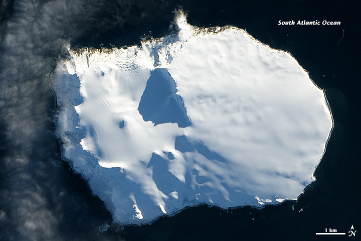
On May 26, 2013, the Operational Land Imager (OLI) on Landsat 8 acquired this natural-color image of Bouvet Island. Thick ice covers more than 90 percent of the island year round. Christensen glacier drains the north side; Posadowsky glacier drains the south side. A ring of volcanic black sand beaches encircles most of the island. (Download the large image to see them). In many areas, the thick layer of ice stops abruptly at the island’s edge, forming steep ice cliffs that plunge to the beaches and oceans below.
Seen from above, one of the most prominent features is Wilhelmplataet caldera, the large circular depression on the western side of Bouvet. Calderas form following volcanic eruptions as land collapses into newly empty or partly-emptied magma chambers. The most recent eruption occurred on Bouvet about 2,000 years ago.
The island is the southernmost extension of the Mid-Atlantic Ridge, the underwater mountain chain that runs through the Atlantic Ocean and serves as the dividing line between the African and South American plates in the southern hemisphere. Bouvet is located near the triple junction between the African, South American, and Antarctic plates.
The highest point—780-meter Olav Peak—lies midway across the island near the northern coast. Notice the long shadows that the peak casts into the caldera. Although it is not particularly tall, the peak's remoteness and the fact that it had never been climbed inspired filmmaker Jason Rodi—who had already climbed the highest mountain on all seven continents—to organize an expedition and give it a try. In 2012, a team of filmmakers, adventurers, and artists landed on the island and climbed to the highest point, where they planted a time capsule.
References
- Beck, W. Bouvet Island: 3Y5X. Accessed November 4, 2013.
- Central Intelligence Agency (2013, July 1) World Factbook: Bouvet Island. Accessed November 4, 2013.
- Earth Observatory (2008, October 6) Bouvet Island, South Atlantic Ocean.
- Johnson, L. Marine geology in the environs of Bouvet Island and the South Atlantic triple junction. Marine Geophysical Researches, 1973 (2), 23-26.
- NOAA Photo Library Bouvet Island. Accessed November 4, 2013.
- Smithsonian Volcano Observatory Bouvet. Accessed November 4, 2013.
- Expedition for the Future The Last Place on Earth: Bouvet Island. Accessed November 4, 2013.
NASA Earth Observatory image by Jesse Allen and Robert Simmon, using Landsat data from the U.S. Geological Survey. Caption by Adam Voiland.
This image record originally appeared on the Earth Observatory. Click here to view the full, original record.