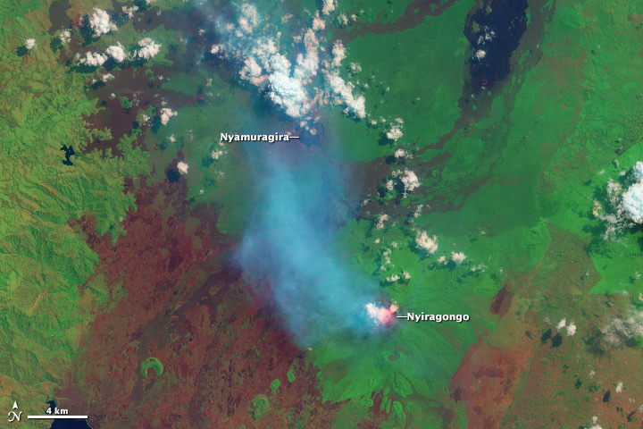
Nyamuragira and Nyiragongo Volcanoes
Downloads
- congo_oli_2013210_swir_lrg.jpg (3276x2184, JPEG)
- congo_oli_2013210_swir_geo.tif (GeoTIFF)
Metadata
- Sensor(s):
- Landsat 8 - OLI
- Data Date: July 29, 2013
- Visualization Date: August 1, 2013
Volcanic plumes stream from Nyamuragira and Nyiragongo volcanoes in this false-color satellite image. The image—combining shortwave infrared, near infrared, and green light—was collected by Landsat 8 on July 29, 2013.
Located in the Democratic Republic of the Congo, near the border with Rwanda and Uganda, the volcanoes are among the most active on Earth. Nyiragongo features a persistent lava lake, revealed by the red glow of shortwave infrared* light. A translucent blue volcanic plume stretches north from Nyiragongo, partially shrouding Nyamuragira. The plume from Nyamuragira is dense and white, suggesting the presence of large amounts of water vapor. The landscape is a mixture of forest (bright green), cleared areas (red-brown), and old lava flows (various shades of black, brown, and green, depending on their age and the amount of vegetation growing on them).
*Shortwave infrared is between near infrared (seen in infrared photography) and thermal infrared light (used by temperature sensors) on the electromagnetic spectrum. Shortwave infrared light is reflected by some surfaces (like bare soil), and emitted by very hot objects (lava or fires).
NASA Earth Observatory images by Robert Simmon, using Landsat 8 data from the USGS Earth Explorer.
This image record originally appeared on the Earth Observatory. Click here to view the full, original record.