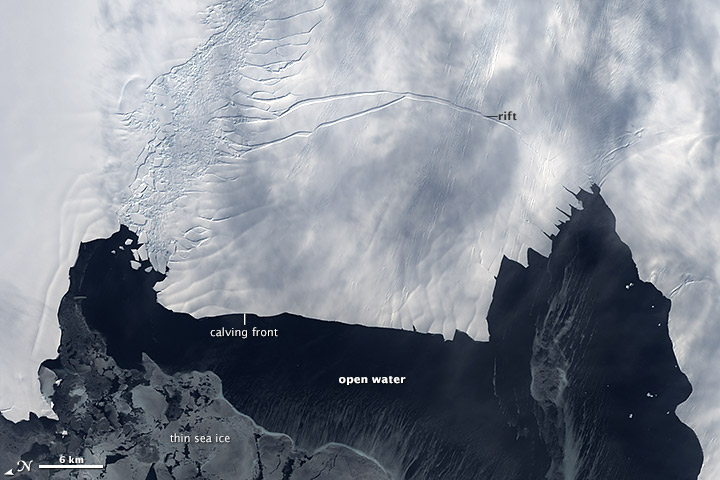
PIG Calving Front Free of Sea Ice
Downloads
- seaice_etm_2012300_lrg.jpg (8171x8831, JPEG)
Metadata
- Sensor(s):
- Landsat 7 - ETM+
- Data Date: October 26, 2012
- Visualization Date: November 21, 2012
On October 14, 2011, scientists flying over the ice shelf at Antarctica’s Pine Island Glacier (PIG) made a startling discovery: there was a massive rift running across part of the glacier’s floating tongue. The rift was 29 kilometers (18 miles) long, 80 meters (260 feet) wide on average, and 50 to 60 meters (170 to 200 feet) deep.
When that crack reaches the other side of the ice shelf, it will send a huge new iceberg drifting into Pine Island Bay. Researchers taking part in NASA’s Operation IceBridge have been closely monitoring the rift for a year with remote sensing equipment.
This image, acquired by the Enhanced Thematic Mapper (ETM) on Landsat 7, shows the rift on October 26, 2012. It still had a few more kilometers to go before reaching the other end of the ice shelf. The arrival of spring in Antarctica had cleared much of the floating sea ice away from Pine Island Glacier’s calving front. There was still some thin sea ice nearby (lower left), but for comparison, see this image when sea ice was more abundant near the front.
Scientists have no way of knowing exactly when the iceberg will break off, but they suspect that the absence of sea ice may hasten the birth. “Sea ice acts as a buttress or a damper to sea swell, protecting the front of these ice shelves or glaciers from calving,” explained NASA glaciologist Kelly Brunt. “So the fact that there’s no sea ice in front of Pine Island Glacier right now implies that it might be primed to calve.”
- Earth Observatory (2011, Oct. 26) Birth of an iceberg.
- Earth Observatory (2011, Nov. 2) IceBridge: Building a record of Earth’s changing ice, one flight at a time.
- Earth Observatory (2012, Feb. 29) Flying through a crack in the ice.
- Discovery News. (2012, Nov. 19) Pine Island Glacier primed to break.
- NASA (2012, Nov. 19) OIB: High and low over the rift. Accessed Nov. 21, 2012.
- NASA (2012, Nov. 19) Pine Island Glacier rift from Landsat. Accessed Nov. 21, 2012.
- NASA (n.d.) Pine Island glacier ice shelf. Accessed Nov. 21, 2012.li>
- NASA (n.d.) Operation IceBridge mission website. Accessed Nov. 21, 2012.
Further Reading
NASA Earth Observatory image created by Matthew Radcliff, using Landsat data provided by the United States Geological Survey. Caption by Adam Voiland, information from Jefferson Beck and Kelly Brunt.
This image record originally appeared on the Earth Observatory. Click here to view the full, original record.