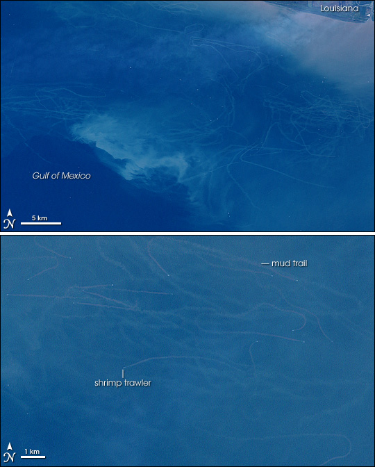
Mudtrails from Fishing Trawlers in Gulf of Mexico
Downloads
- shrimp_l7_1999297_lrg.jpg (6000x4000, JPEG)
- shrimp_l7_24oct99_crop_geo.tif (6000x6000, GeoTIFF)
- ge_07751.kml (KML)
Metadata
- Sensor(s):
- Landsat 7 - ETM+
- Data Date: October 24, 1999
- Visualization Date: June 7, 2007
No fishing activity causes more physical and ecological “collateral damage” than bottom trawling. Fishing boats drag large nets across the sea floor, scooping up seafood from shrimp to squid. But in addition to their harvesting of intended species, many trawls indiscriminately capture non-target species, like sea turtles, which are discarded. Trawling crushes or destroys the seafloor habitat that feeds and shelters marine life; the nets literally scrape the mud off the ocean bottom. As the mud resettles, it can smother surviving bottom-dwelling creatures.
The pervasiveness of the influence of bottom trawlers on the Gulf of Mexico is evident in these images from NASA’s Landsat satellite. Showing two different areas of a single scene captured on October 24, 1999, the images reveal dozens of mudtrails streaking the Gulf in the wake of numerous trawlers, which appear as white dots. The amount of re-suspended sediment dredged up by the trawlers gives the water a cloudy appearance.
These images are part of a collection of satellite images of trawler mudtrails put together by scientists from Duke University and University of British Columbia to demonstrate both the profound impact of bottom trawling on ocean habitats around the globe and the potential of satellite data for routine monitoring of those impacts. The scientists made a version of the collection available as a tour on Google Earth.
- Safina, C. (1998).Scorched-Earth Fishing, Issues in Science and Technology Online.
- Kyle Van Houtan and Daniel Pauly’s Research on Trawler Mudtrails
- Ocean Studies Board of the National Research Council. (2002). Effects of Trawling and Dredging, Effects of Trawling and Dredging on Seafloor Habitat. National Academies Press: Washington, D.C.
NASA image created by Jesse Allen, using data obtained from the University of Maryland’s Global Land Cover Facility.
This image record originally appeared on the Earth Observatory. Click here to view the full, original record.