Landsat in Memory of the World Register
Downloads
- SantaBarbara_mss_19780518_lrg.jpg (1458x1444, JPEG)
Metadata
- Sensor(s):
- Landsat 4 - MSS
- Data Date: May 18, 1978
- Visualization Date: November 22, 2011
What do the Gutenberg Bible, Tolstoy’s personal library, the Book of Kells—an 8th century illuminated manuscript, created by Celtic monks—and the Landsat Multispectral Scanner System (MSS) data archive have in common? They are all among the 245 international documentary collections that make up the Memory of the World Register. The register is a UNESCO (United Nations Educational, Scientific and Cultural Organization) effort to preserve access to documentary heritage around the world.
The Landsat Multispectral Scanner (MSS) data archive of 652,000 images of Earth was nominated to be part of the register in 2010. In 2011, it was officially accepted along with six other submissions—including Byzantine manuscripts from Georgia and early reports from the 1922 first flight across the South Atlantic.
As stated in the Landsat nomination: “There is simply no other image record of the Earth’s land regions at this scale or over the same period of time (1972-1992).”
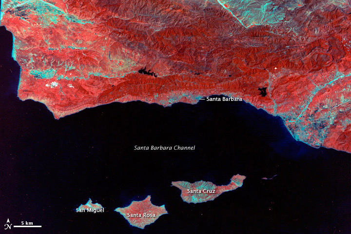
The image above, showing southern California, is one of thousands in the twenty-year archive. Landsat MSS acquired the image on May 18, 1978. Plant-covered land is red, with forests on the mountain ranges a darker shade than vegetation at lower elevations. Bare ground and cities are pale blue, and water is dark blue and black. The image provides a baseline from which scientists can measure changes in land use, urban growth, or the impacts of natural disasters.
All U.S.-held Landsat data are managed by the U.S. Geological Survey, which maintains original digital files in its primary archives, plus back-up copies in off-site locations. Each Landsat “scene”—with 79-meter spatial resolution and 185-by-185 kilometer area—fills an important scientific niche because the sensor provided global, seasonal coverage. Its images are also detailed enough to characterize human activities, such as urban expansion, agricultural irrigation, and deforestation.
With a baseline knowledge of Earth’s land areas in the early 1970s, and then comparative images over time, Landsat has allowed scientists to detect and evaluate environmental change. Often, this baseline knowledge has taken the form of a map, as Landsat and cartographers have a long history together. Paul Lowman, a pioneer in Earth remote sensing at NASA’s Goddard Space Flight Center, drew the first map from a Landsat image in July 1972.
Since that time, Landsat-derived maps have been used to aid in navigation through poorly charted areas, especially in the Arctic and Antarctic. Landsat images have been used to map geologic faults and fracture zones, as well as global tectonic activity. The images also have been used to find previously unmapped volcanoes.
Image created by Laura Rocchio using Landsat data provided by the United States Geological Survey. Caption by Laura Rocchio, originally published on the Landsat web site.
This image record originally appeared on the Earth Observatory. Click here to view the full, original record.