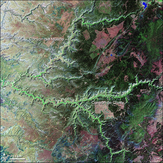
Canyon de Chelly National Monument
Downloads
- cdchelly_l7_2000256_lrg.jpg (1868x1868, JPEG)
Metadata
- Sensor(s):
- Data Date: September 12, 2000
- Visualization Date: April 2, 2006
Canyon de Chelly National Monument was created in 1931 to protect the cultural heritage of the canyon lands of Arizona. The monument is unique in the U.S. National Park system because it lies entirely on Navajo Tribal Trust Land. Members of the Navajo Nation sill live in the rugged, harsh, and beautiful landscape, which is located in the Four Corners region of the American Southwest. The monument, located in northeastern Arizona right near the border with New Mexico, is managed jointly by the National Park Service and the Navajo Nation.
This false-color image was created using data obtained by Landsat 7’s Enhanced Thematic Mapper Plus (ETM+) instrument on September 12, 2000. In this image, healthy vegetation shows up as verdant green, filling the floors of the canyons. The patchwork of deep greens and deep pinks above the canyons is a mixture of forested hillsides and open grazing lands on Defiance Plateau. The small, brilliant blue patch at the top of Canyon del Muerto is Tsaile Lake, which supplies the nearby town of Tsaile with water. The monument extends down the canyon below this lake, encompassing Canyon del Muerto to the point where it joins Canyon de Chelly, Canyon de Chelly itself, and the small canyons that feed into each of these two larger canyons. The plateau area above the canyon rims is Tribal Trust Land outside the monument’s boundaries.
According to the National Park Service Website on Canyon de Chelly, the area is one of the oldest continuously inhabited regions of North America. The first evidence of human habitation in the area dates from around A.D. 300, and it has been almost continuously occupied since. The most dramatic of the archaeological remains in the area come from the Ancestral Puebloans whose buildings were tucked under overhangs in the canyons. The Navajo arrived in the area around 1600 and became semi-nomadic farmers. The canyon lands provided shelter from their enemies as well as a suitable place in the valleys to raise crops and tend sheep, which they still do in the valley floor to this day. The ruins and living communities in the monument are its main attractions, though the scenery is also stunning. Visitors are able to explore the tops of the canyons on their own, but because of the cultural sensitivity of the land (both past and present), visitors must have a local guide to enter the depths of the actual canyons.
NASA image created by Laura Rocchio, Landsat Project Science Office.
This image record originally appeared on the Earth Observatory. Click here to view the full, original record.