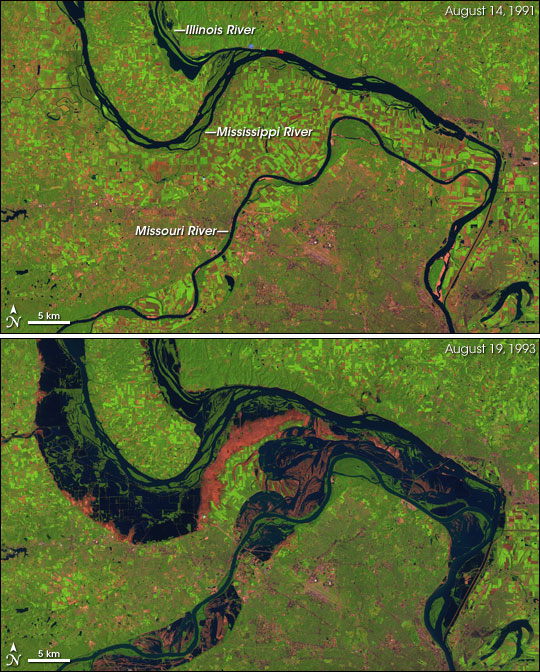
Great Flood of the Mississippi River, 1993
Downloads
- stlouis_l5tm_19aug93_30m.jpg (3600x3600, JPEG)
- stlouis_tm5_19aug93_crop_geo.tif (3600x3600, GeoTIFF)
- stlouis_l5tm_14aug91_30m.jpg (3600x3600, JPEG)
- stlouis_tm5_14aug91_crop_geo.tif (3600x3600, GeoTIFF)
- ge_05422.kml (KML)
Metadata
- Sensor(s):
- Landsat 5 - TM
- Data Date: August 19, 1993
- Visualization Date: April 17, 2005
During the first half of 1993, the U.S. Midwest experienced unusually heavy rains. Much of the United States in the upper reaches of the Mississippi River drainage basin received more than 1.5 times their average rainfall in the first six months of the year, and parts of North Dakota, Iowa, and Kansas experienced more than double. The rains often arrived in very intense storms. Floods overwhelmed the elaborate system of dykes and other water control structures in the Mississippi River basin, leading to the greatest flood ever recorded on the Upper Mississippi. In St. Louis, the Mississippi remained above flood stage for 144 days between April 1 and September 30, 1993.
This image pair shows the area around St. Louis, Missouri, in August 1991 and 1993. The 1993 image was captured slightly after the peak water levels in this part of the Mississippi River. Flood waters had started to recede, but remained well above normal. This false-color image was created by combining infrared, near infrared, and green wavelengths of light observed by the Thematic Mapper (TM) instrument onboard the Landsat 5 satellite (TM bands 5, 4, and 2 respectively). Water appears dark blue, healthy vegetation is green, bare fields and freshly exposed soil are pink, and concrete is grey. The scale of flooding in the river basins of the Illinois, Missouri, and Mississippi Rivers in 1993 is immense. The deep pink scars in the 1993 image show where flood waters have drawn back to reveal the scoured land.
Other factors contributed to the severity of the flooding that year. The previous year had been cooler than average, which decreased evaporation from the soil and allowed the heavy rains to saturate the ground rapidly. In addition, widespread landcover change along rivers and streams has dramatically altered the natural flood control systems: wetlands that can absorb large amounts of water and release it slowly over time. The network of levees, canals, and dams in the Upper Mississippi Basin was unable to control the floods of 1993.
Spurred by this massive disaster, geologist Robert Brackenridge of Dartmouth College brought the tools of satellite remote sensing to bear on the issue of flood management, prediction, and monitoring. You can read about his work in the feature article High Water: Building A Global Flood Atlas.
NASA images created by Jesse Allen, Earth Observatory, using data provided courtesy of the Landsat Project Science Office.
This image record originally appeared on the Earth Observatory. Click here to view the full, original record.