
Logging and Regrowth in Washington State
Downloads
- washington_tm5_1984201_lrg.jpg (3081x3081, JPEG)
- washington_tm5_2010224_lrg.jpg (3081x3081, JPEG)
Metadata
- Sensor(s):
- Landsat 5 - TM
- Data Date: July 19, 1984 - August 12, 2010
- Visualization Date: July 1, 2011
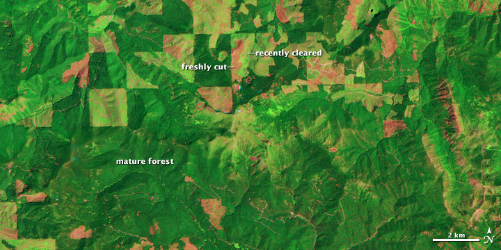
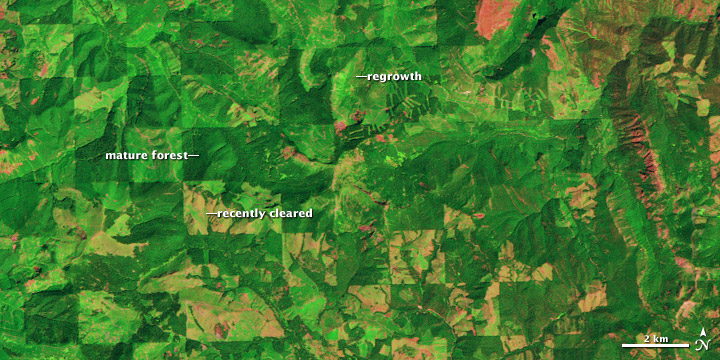
A checkerboard pattern spread across mountains and valleys is usually a signature of agriculture. These squares in Washington state are no exception, but the crop being farmed is trees, and the growing season spans decades. This pair of images, both from the Landsat 5 satellite, shows grids of forest disappearing and gradually regrowing over 26 years.
In 1984, logging in the area appears to be in the early stages. In many places, red-brown earth is exposed under the swaths of freshly cut forest. Other grids, cleared just a bit earlier, are pale green with newly growing grasses or very young trees. The rest of the image is dominated by the deep green of dense, mature forest.
In 2010, the logging operation seems to be more mature. There is little evidence of fresh cuts, but some areas have been recently cleared. Pockets of mature forest remain, and forest is regrowing in other places. Grids that had been clear in 1984 are forested in 2010.
Trees become houses, furniture, paper products, and myriad other products that we use every day. Trees are also important because they take carbon dioxide from the atmosphere and convert it to the sugars that make up the leaves and wood of the tree. Trees store carbon. The Earth Observatory’s new carbon cycle article describes the impact of deforestation on the carbon cycle:
When we clear forests, we remove a dense growth of plants that had stored carbon in wood, stems, and leaves—biomass. By removing a forest, we eliminate plants that would otherwise take carbon out of the atmosphere as they grow. We also expose soil that vents carbon from decayed plant matter into the atmosphere. Humans are currently emitting just under a billion tons of carbon into the atmosphere per year through land use changes. Changes that put carbon gases into the atmosphere result in warmer temperatures on Earth.
Satellite images like these help scientists estimate how much carbon dioxide goes into the atmosphere when a forest is cleared, and how much carbon dioxide is being taken out of the atmosphere as a forest regrows.
Read more in the Carbon Cycle feature.
NASA Earth Observatory image created by Robert Simmon, using Landsat data provided by the Landsat Project Science Office. Landsat is jointly managed by the U.S. Geological Survey and NASA. Caption by Holli Riebeek.
This image record originally appeared on the Earth Observatory. Click here to view the full, original record.