Pakistan Flood 2010
Downloads
- pakistan_post_742.tif (6340x11245, TIFF)
- pakistan_pre_742.tif (6340x11245, TIFF)
Metadata
- Sensor(s):
- Landsat 5 - TM
- Data Date: July 11, 2010 - August 12, 2010
- Visualization Date: September 15, 2010
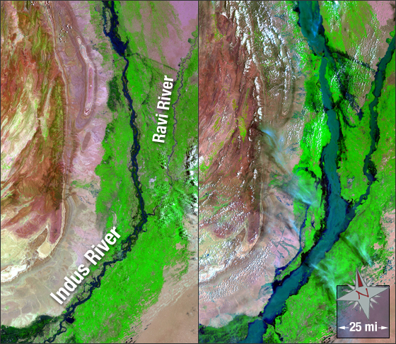
Flooding in Pakistan began in late July 2010 following heavy monsoon rains. The Indus River swelled as did many other rivers and by August 19 nearly one-fifth of Pakistan was flooded. It is estimated that over 2000 people have died, over a million homes have been destroyed and over 20 million people have been affected as of August 31, 2010.
In this image the Indus River (blue) is shown before the flood (on July 11, 2010; left) and during the flood (on August 12, 2010; right). Vegetation appears green and bare earth is shown in colors ranging from pink to tan.
These Landsat 5 pseudo-true color images were created using TM bands 7, 4 and 2. They were acquired on July 11, 2010 and August 12, 2010. The images fall on Landsat WRS-2 Path 151 Rows 40/39.
NASA GSFC Landsat/LDCM EPO Team