Gulf of Mexico Oil Spill 2010
Downloads
- Gulf_Mexico_oil_spill_1.tif (8401x7221, TIFF)
- Gulf_Mexico_oil_spill_3.TIF (8281x7191, TIF)
- Gulf_Mexico_oil_spill_4.tif (16802x14382, TIFF)
Metadata
- Sensor(s):
- Landsat 7 - ETM+
- Data Date: May 1, 2010
- Visualization Date: May 19, 2010
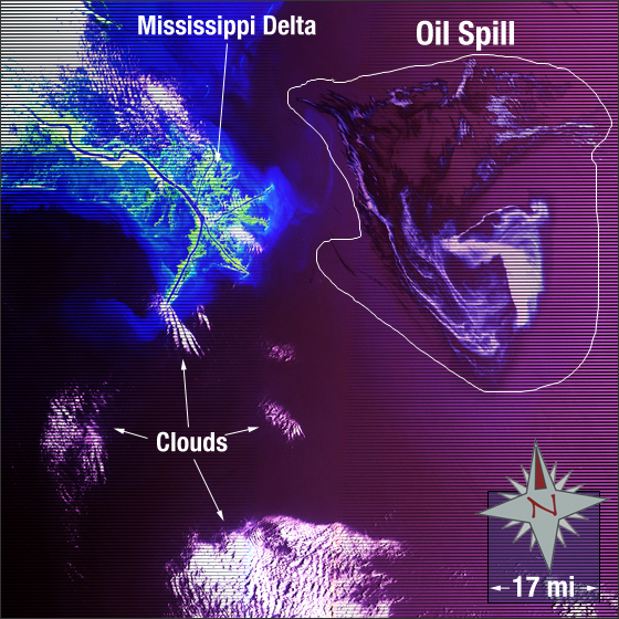
On April 20, 2010 the Deepwater Horizon offshore drilling rig located in the Gulf of Mexico experienced an explosion resulting in at least 11 deaths and creating a massive oil spill. The oil well continues to exude 210,000 to 1,100,000 gallons of oil a day.
In this image the Mississippi Delta is displayed on the left and the oil spill can be seen on the right. The image colors have been enhanced to increase visibility of the oil spill. Vegetation appears green, sediment-laden effluence from the delta appears light blue, clouds are white, the Gulf of Mexico is magenta, and the oil spill is a deep to light purple.
This Landsat 7 false-color composite image was created using ETM+ bands 7,4, and 2. It was acquired on May 1, 2010. The image falls on Landsat WRS-2 Path 21 Row 40.
NASA GSFC Landsat/LDCM EPO Team