

30th Anniversary of the Eruption of Mt. St. Helens
Downloads
- sthelens_ms3_19790829_lrg.jpg (1300x1300, JPEG)
- sthelens_ms2_19800924_lrg.jpg (1300x1300, JPEG)
- sthelens_tm5_20090910_nir_lrg.jpg (2048x2048, JPEG)
- sthelens_1979-2009_hd.mov (QuickTime)
- sthelens_1979-2009_sd.mp4 (MPEG)
- mtsthelens_series.kml (KML)
Metadata
- Sensor(s):
- Landsat 5 - TM
- Data Date: August 29, 1979 - September 10, 2009
- Visualization Date: May 17, 2010
In mid-March 1980, a series of small earthquakes began shaking the ground at Mt. St. Helens in southern Washington. Over the next two months, the northern flank of the mountain was deformed by a large bulge—a sign that upwelling magma was pushing up on the rock from below. On the morning of May 18, an earthquake caused the entire north flank of the volcano to collapse in a massive avalanche. Relieved of the overlying pressure, the volcano ejected a blast of rocks, ash, gas, and steam that blew down and buried several hundred square miles of forest.
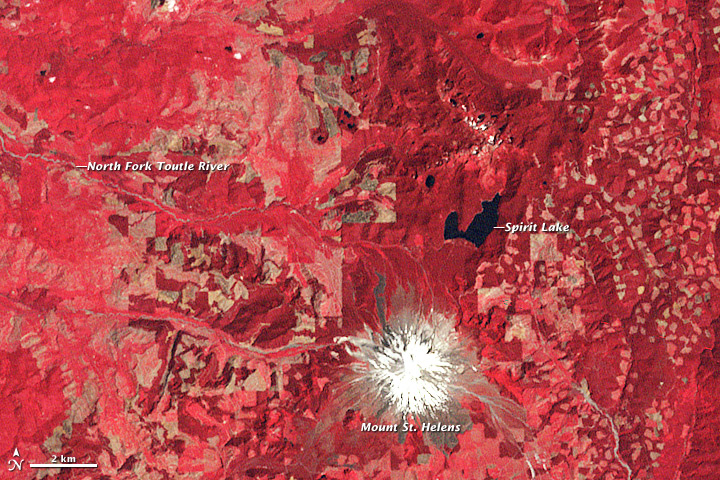
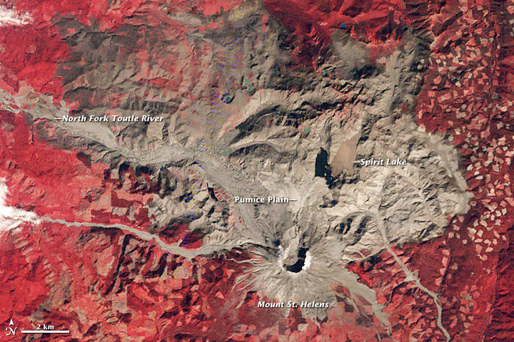
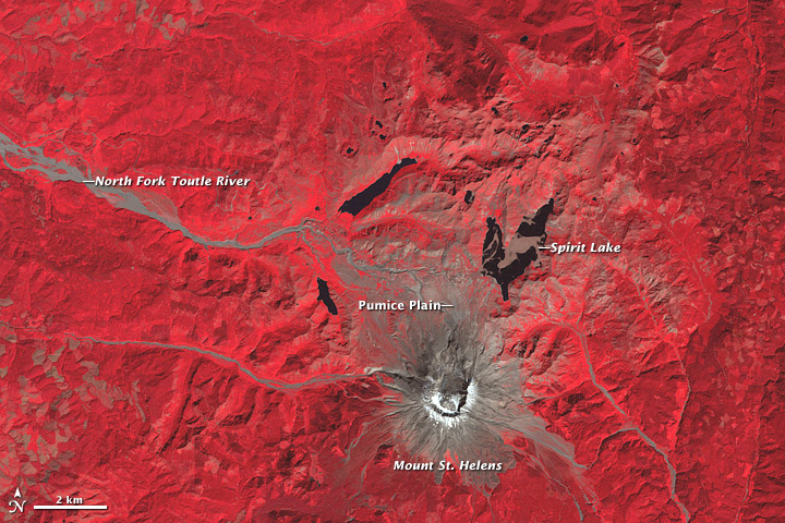
This trio of false-color Landsat satellite images is part of a 30-year time series documenting the destruction and recovery at Mt. St. Helens. Vegetation is red, bare rock and volcanic debris are gray, and clear water is dark blue. (In the complete time series, images from 1984 onward are in photo-like natural color.) The 1979 view (top) shows the snow-covered summit of the perfectly shaped stratovolcano, and the mixture of forest types surrounding the mountain. The darkest red areas are likely undisturbed forests (e.g., north of the volcano), while to the east is a patchwork of forest and logging clear cuts. Lighter red vegetation northwest and west of the volcano are probably tree plantations.
The image from September 24, 1980 (middle), shows the devastation of the May 18 eruption. The northern flank of the mountain collapsed, producing the largest landslide in recorded history. The avalanche buried 14 miles (23 kilometers) of the North Fork Toutle River with an average of 150 feet (46 meters)—but in places up to 600 feet (180 meters)—of rocks, dirt, and trees. The blast spread rock and ash (gray in the images) over 230 square miles (600 square kilometers). A raft of dead trees floats across Spirit Lake. Volcanic mudflows (lahars) poured down rivers and gullies around the intact flanks.
Three decades later, the image from September 10, 2009, shows the recovery in the blast zone. Most of the landscape within the blast zone has at least a tinge of red, meaning vegetation has recolonized the ground. The flanks of the volcano itself are still bare, as is a broad expanse north of the volcano called the Pumice Plain. Directly in the path of the landslide and several pyroclastic flows, this area has been slowest to recover.
Ground surveys, however, have found even this seemingly barren area is coming back to life: the first plant to re-appear was a prairie lupine, which can take nitrogen—a critical plant nutrient—straight from the air rather than from the soil. These small wildflowers begin the crucial task of rebuilding the soil and attracting insects and herbivores. This process is underway on the Pumice Plain, even though it is not yet visible from space.
References
- Bishop, J., Fagan, W., Schade, J., & Crisafulli, C. (2005). Chapter 11: Causes and Consequences of Herbivory on Prairie Lupine (Lupinus lepidus) in Early Primary Succession. In Ecological responses to the 1980 eruption of Mount St. Helens [Dale, V. H., Swanson, F. J., Crisafulli, C. M., Eds.] (pp. 151-161). Birkhauser. Retrieved online [Google Books] May 17, 2010.
- Brantley, S. & Myers, B. (2000). Mount St. Helens -- From the 1980 Eruption to 2000: U.S. Geological Survey Fact Sheet 036-00. Retrieved May 17, 2010.
- Clynne, M., Ramsay, D., & Wolfe, E. (2005). Pre-1980 Eruptive History of Mount St. Helens, Washington | USGS Fact Sheet 2005-3045. Retrieved May 17, 2010.
NASA images by Robert Simmon, based on Landsat 2,3, and 5 data. Animation by Jennifer Shoemaker. Caption by Rebecca Lindsey.
This image record originally appeared on the Earth Observatory. Click here to view the full, original record.