Evansville, Indiana
Downloads
- Evansville_IN.tif (5159x5159, TIFF)
Metadata
- Sensor(s):
- Landsat 5 - TM
- Data Date: November 6, 2005
- Visualization Date: January 6, 2010
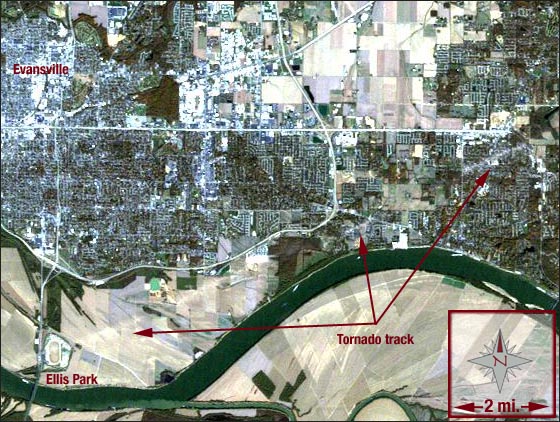
On Nov. 6, 2005, a tornado tore through southwest Indiana leaving a path of destruction 400 yards wide and 41 miles long. The tornado was classified as an F3 on the Fujita-Pearson Scale, meaning it was a severe tornado with wind speeds between 158 and 206 mph.
The destructive vortex of wind touched down just before 2 a.m. on a Sunday morning. The timing of the storm caused many people to sleep unknowingly through the tornado warnings that were issued, leading to 24 casualties and making it the deadliest 2005 U.S. tornado.
After crossing the Ohio River, the powerful tornado directly hit the 73-year old Ellis Park racetrack. The facility was severely damaged and several racehorses met their demise.
In this image, the Ohio River can be seen as it snakes across the lower portion of the scene. Evansville can be found in the upper left of the image, and the damaged Ellis Park can be seen just north of the Ohio River in the lower left corner. The northern portion of the tornado’s track can be seen as a light-colored line extending from Ellis Park to the mid-right edge of the image.
This Landsat 5 image was acquired on Nov. 10, 2005. It uses the Thematic Mapper (TM) spectral bands 3, 2, and 1, making the image appear as a “natural color†image. Evansville falls on Landsat WRS-2 Path 22 Row 34.
NASA GSFC Landsat/LDCM EPO Team