Houma, Louisiana - Hurricane Gustav
Downloads
- Houma_LA_pre.tif (7660x6872, TIFF)
- Houma_LA_post.tif (7660x6872, TIFF)
Metadata
- Sensor(s):
- Landsat 5 - TM
- Data Date: September 30, 2008
- Visualization Date: December 28, 2009
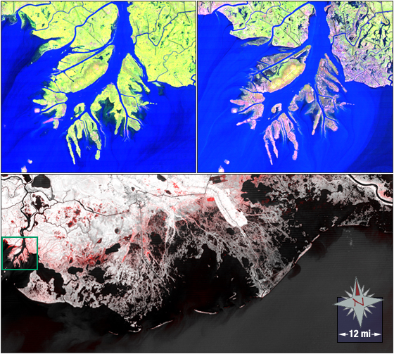
Hurricane Gustav made landfall in coastal Louisiana on September 1, 2008, as a very strong category 2 (almost category 3) hurricane and left its mark on wetlands and barrier islands. After Hurricane Gustav made landfall Landsat data provided picture-proof that wetlands and barrier islands off the Louisiana coast, southwest of New Orleans, were lost from hurricane-related flooding.
In the top two images vegetated areas look green, low vegetation areas look pink to white, and water bodies blue to dark blue. The bottom image was created by overlaying and comparing NDVI images of the Louisiana coast from before and after Hurricane Gustav. NDVI is an index of vegetation cover. White in the bottom image represents vegetation and red shows areas denuded by Hurricane Gustav.
These images were acquired on August 30, 2008 and October 1, 2008. The Landsat 5 false-color images at the topof the page were created using bands 5, 4 and 3. . Houma, Louisiana falls on Landsat WRS-2 Path 22 Row 40.
Text excerpted from Rob Gutro.
NASA GSFC Landsat/LDCM EPO Team