acquired September 25, 2001
Christchurch, New Zealand
Downloads
- Christchurch.tif (3525x3525, TIFF)
Metadata
- Sensor(s):
- Landsat 7 - ETM+
- Data Date: September 25, 2001
- Visualization Date: December 1, 2009
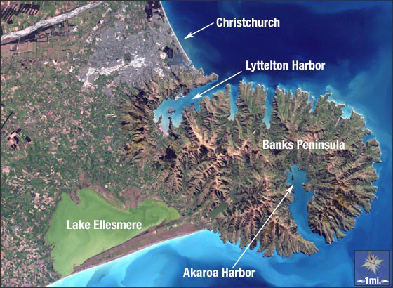
Christchurch is New Zealand’s second largest city. It is located on the South Island’s eastern shore at the southern end of Pegasus Bay and just north of Banks Peninsula.
The oval shape of Banks Peninsula dominates this image. The peninsula is what remains of two large volcanoes that once stood nearly 5,000 feet above the sea. Lyttelton and Akaroa Harbors mark the location of the two major volcanic craters. Today, the tallest peaks on Banks Peninsula are less than 2,000 feet.
This Landsat 7 image was acquired on September 25, 2001. It is a natural-color composite of ETM+ bands 3, 2, and 1. Christchurch can be found on Landsat WRS-2 Path 73 Row 90.
NASA GSFC Landsat/LDCM EPO Team