Aceh, Indonesia
Downloads
- Aceh.tif (2300x2300, TIFF)
Metadata
- Sensor(s):
- Landsat 7 - ETM+
- Data Date: December 13, 2004
- Visualization Date: November 24, 2009
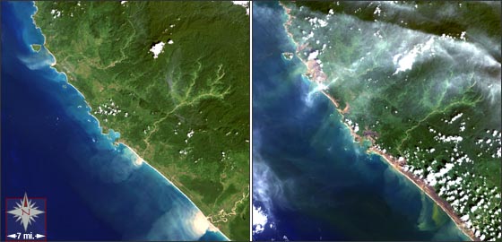
On December 26, 2004, a devastating tsunami ravaged many coastal regions on the Indian Ocean. One of the worst hit regions was the Aceh Province on the northern end of Sumatra (part of Indonesia). The tsunami inundated the low-lying areas of Aceh with seawater taking vegetation, manmade structures and lives with its force. In its wake, the tsunami left a denuded coastal area (brown areas above).
The Landsat 7 above on the left was captured nearly two weeks before the tsunami while the rightmost image was acquired three days after the event. Both images use the ETM+ bands 3,2,1 which create a true-color image.
A Landsat 7 science team member, David Skole along with his colleagues at the Tropical Rain Forest Information Center at Michigan State University used Landsat 7 data to aid the Indonesian government with relief efforts in the Aceh Province of Sumatra.
Using Landsat 7 data collected three days after the disaster, the MSU team created regional impact maps which were used by the Indonesian government to direct relief efforts. The broad regional coverage and high spatial resolution of the ETM+ sensor made this work possible.
NASA GSFC Landsat/LDCM EPO Team