
Rare Refill of Lake Eyre, Australia’s Simpson Desert
Downloads
- lakeeyrefan_tm5_2009129_lrg.jpg (2400x1600, JPEG)
- lakeeyrefan_tm5_09may09_geo.tif (2400x1800, GeoTIFF)
- lakeeyrefan_tm5_2009049_lrg.jpg (2400x1600, JPEG)
- lakeeyrefan_tm5_18feb09_geo.tif (2400x1800, GeoTIFF)
- ge_38717.kml (KML)
Metadata
- Sensor(s):
- Landsat 5 - TM
- Data Date: May 9, 2009
- Visualization Date: May 22, 2009
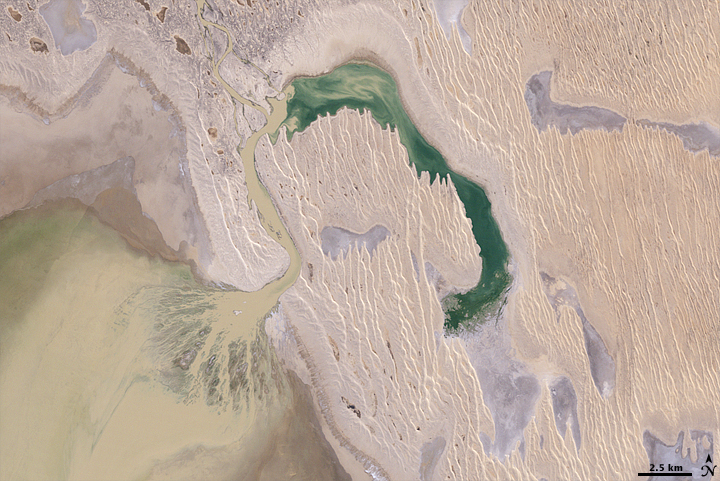
Waves in central Australia’s Simpson Desert usually come in the form of sand dunes. In these images, they ripple in long vertical lines across the surface of the desert. But occasionally, summer rain from northern Australia flows down into the desert, filling dry river channels and empty lake beds. Very occasionally, the water reaches a vast lake bed called Lake Eyre, turning it into a shallow inland sea where birds flock to breed.
In early 2009, heavy rains brought major flooding to nearly every river system in Queensland, Australia. By May, the water had made its way south and had started to fill Lake Eyre. The top image provides a natural-color view of water pouring into the lake through one of many channels that drain the desert during the rainy season. The muddy brown water spreads into the lake in a triangular delta.
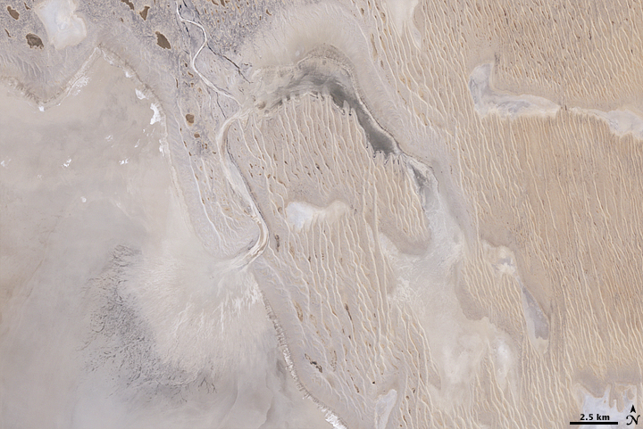
The Landsat-5 satellite captured the top image on May 9, 2009. The lower image, which shows the region on February 18, 2009, provides a view of normal conditions in the desert. The landscape has been carved by the occasional flow of water across the surface. Even in dry conditions, the river channel and the delta are imprinted on the land.
As water flows through Lake Eyre and the surrounding river channels, lakes, and lagoons, the desert is transformed. Wildflowers flourish, and the lake becomes a breeding ground for thousands of birds, such as pelicans. As many as 60,000 birds had been observed in the Lake Eyre region as of May 17, 2009, reported the Australian Broadcasting Corporation.
References
- Australian Broadcasting Corporation News. (2009, May 17). Floods Transform Lake Eyre. Accessed May 22, 2009.
NASA image created by Jesse Allen, using Landsat data provided by the United States Geological Survey. Caption by Holli Riebeek.
This image record originally appeared on the Earth Observatory. Click here to view the full, original record.