The Drumlin Islands of Boston Harbor
Downloads
- bostonharbor_oli_20240719_lrg.jpg (1860x1240, JPEG)
Metadata
- Sensor(s):
- Landsat 8 - OLI
- Data Date: July 19, 2024
- Visualization Date: April 22, 2025
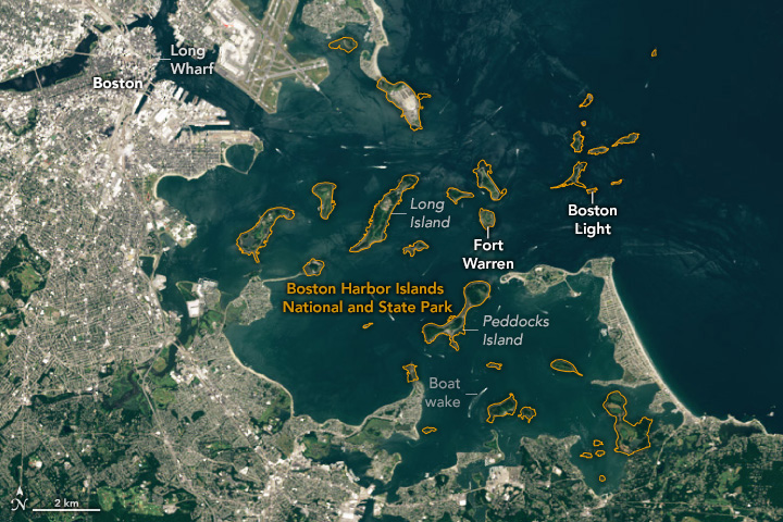
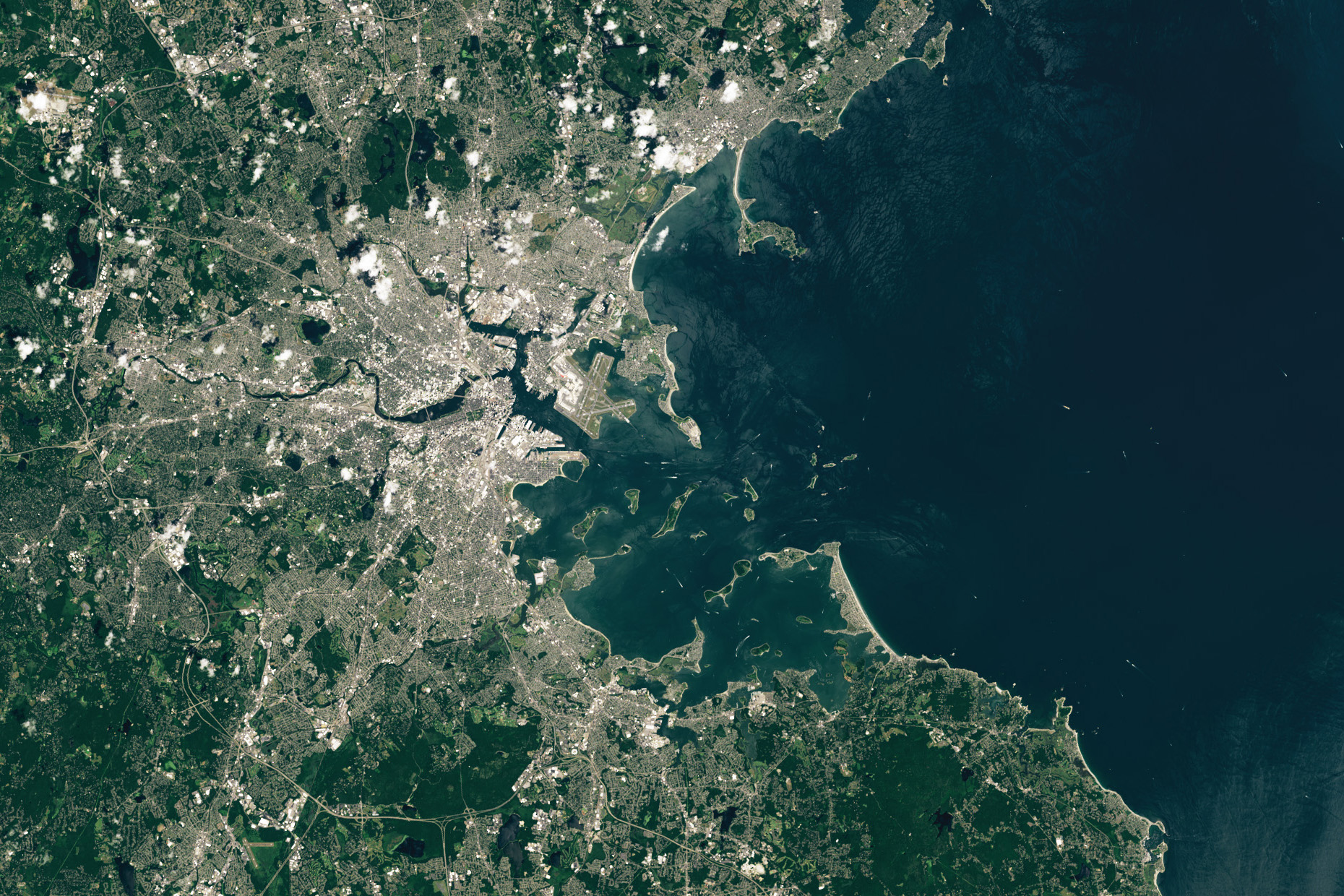
About 20,000 years ago, during the peak of the Wisconsin Glaciation, a massive ice sheet—over a mile thick in places—blanketed the land that now makes up Boston Harbor. As this ice melted and eventually retreated, it left piles of sediment and glacial debris in hundreds of elongated, streamlined hills called drumlins. Rising seas eventually flooded the features and turned many into islands, creating the only partially submerged drumlin field in North America and one of only three in the world.
Several of these drumlin islands and peninsulas now make up the heart of the Boston Harbor Islands National and State Park, which preserves many distinctive geological, historical, and natural resources. The OLI (Operational Land Imager) on Landsat 8 captured this image of the harbor and its drumlin islands on July 19, 2024.
Of the park’s 34 islands and peninsulas, only four are accessible by car: Deer Island, Nut Island, World’s End, and Webb Memorial. Four others—Spectacle Island, Georges Island, Peddocks Island, and Thompson Island—are served by seasonal ferries, and several more are accessible by private boat. The park is governed by the Boston Harbor Islands Partnership, a federally legislated body made up of eleven agencies.
The islands support a range of ecosystems, including salt marshes, sandy beaches, seagrass beds, tidal pools, mudflats, grasslands, and hardwood forests. Lobsters, crabs, clams, and fish such as striped bass, bluefish, and flounder inhabit the waters surrounding the islands. Mussels and barnacles live in the intertidal zones, and dozens of mammal, bird, reptile, and amphibian species can be found on land.
Many of the islands have signs of human activity and history, from campgrounds, education centers, and homes, to former military infrastructure, fields, and health facilities. Long Island, for instance, was once connected to Boston via a highway bridge and contains aging government buildings, a performing arts center, fire station, chapel, crematorium, and other structures. (The bridge was closed in 2014.) Peddocks Island, one of the largest, has privately owned cottages on its western end and the remains of a coastal fort.
Little Brewster Island hosts Boston Light, the oldest continually operated light station in the United States. While the lighthouse initially used tallow candles when it was built in 1716, kerosene was used starting in 1913. Today, two 1,000-watt electric light bulbs produce a 1.8 million-candlepower white light.
Nearby Georges Island houses the remains of Fort Warren, a bastion-style fort built in the shape of a pentagon between the 1830s and 1860s. The fort was named after Revolutionary War hero Joseph Warren, the man who sent Paul Revere on his famous “Midnight Ride” before the Battles of Lexington and Concord. During the Civil War, the fort was used as a prison for Confederate officers and government officials, including Confederate Vice President Alexander Stephens. The fort was mostly constructed of granite blocks sourced from nearby quarries in Quincy and Cape Ann.
Farther west lies Long Wharf, a historically significant wharf at the base of today’s State Street that once served as a hub for Boston’s maritime trade. When it first opened in the 1720s, the wharf extended half a mile into the harbor, allowing up to 50 vessels to dock at once. Boston’s ports have evolved over the decades and centuries, with container cargo and cruise ships now arriving at terminals in South Boston and recreational boats docking at a marina on Long Wharf.
Editor’s Note: Explore satellite imagery of other national parks for National Park Week.
References
- Boston Harbor Islands Partnership Boston Harbor Islands National & State Park. Accessed April 22, 2025.
- Boston Waterboat Marina Historic Boston Harbor. Accessed April 22, 2025.
- Commonwealth of Massachusetts Boston Harbor Islands. Accessed April 22, 2025.
- National Park Service (2017, March) NPS Geodiversity Atlas—Boston Harbor Islands National Recreation Area, Massachusetts. Accessed April 22, 2025.
- National Park Service Boston Harbor Islands National Recreation Area. Accessed April 22, 2025.
NASA Earth Observatory image by Wanmei Liang, using Landsat data from the U.S. Geological Survey. Story by Adam Voiland.
This image record originally appeared on the Earth Observatory. Click here to view the full, original record.