Farming on the Straight, Curved, and Narrow
Downloads
- suloszowaag_oli2_20240813_lrg.jpg (5518x6131, JPEG)
- suloszowaagzm_oli2_20240813.jpg (720x800, JPEG)
Metadata
- Sensor(s):
- Landsat 9 - OLI-2
- Data Date: August 13, 2024
- Visualization Date: March 18, 2025
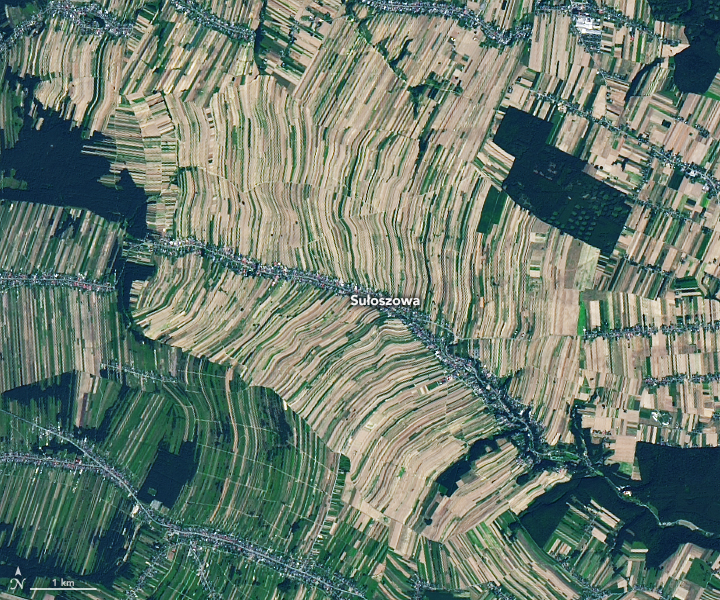
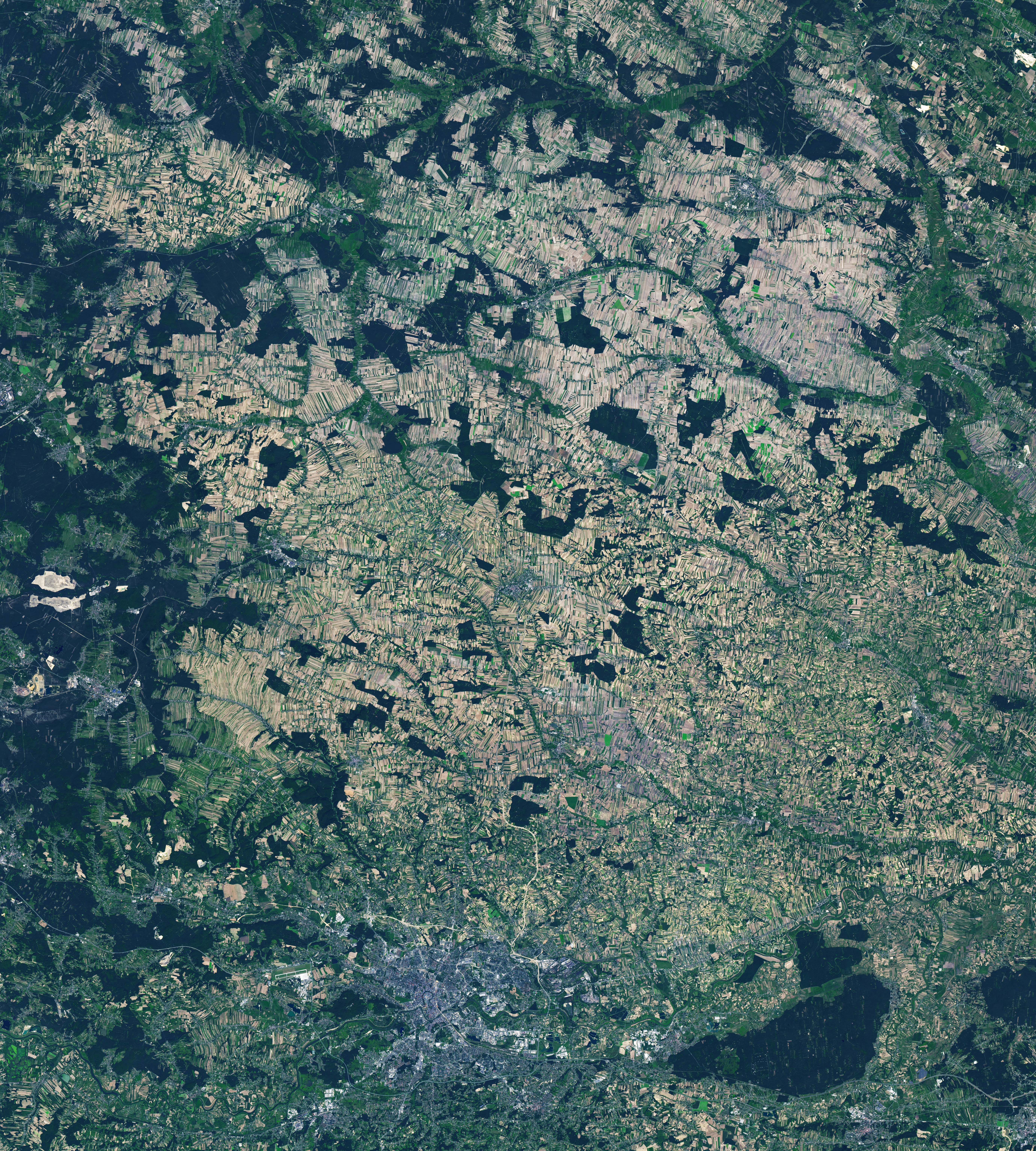
When viewed from space, agricultural regions may reveal neat rectangular grids or arrays of perfect circles. In southern Poland, however, farming developed along different lines. Over centuries, settlements clustered around rivers and roads, forests were cleared for farming, and land was divided from generation to generation. The narrow slivers of fields that developed—some just tens of meters wide—come together into striped patterns that are equal parts jumbled and orderly.
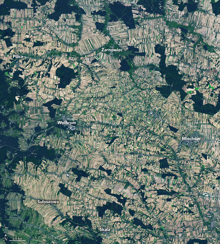
This image, acquired with the OLI-2 (Operational Land Imager-2) on Landsat 9 in August 2024, shows the intricate patchwork of ribbon-like fields around Sułoszowa. The village of about 5,500 people is located 25 kilometers (15 miles) northwest of Kraków, Poland’s second-largest city. In the center of the image, farm plots snake away from a linear stretch of homes along Sułoszowa’s main road. Groups of narrow fields emanate from other linear settlements in this image, interrupted by patches of dark-green forest.
This pattern of rural development bears similarity to the Waldhufendörfer, or “forest villages,” in Germany, where strips of land extend from houses near roads or streams. Likewise, the pattern manifests as tracts of “long lots” in parts of North America that were influenced by French settlers.
This style of farming began developing in Poland around the turn of the 17th century. Settlements were established along streams and roads that generally paralleled the streams. Each settler had a similar area of land about 400 meters (1,300 feet) wide, on average, with access to the road and water.
Decrees in the 18th and 19th centuries allowed peasants to pass land down to their children, said Michigan State University geographer Arika Ligmann-Zielinska, leading to continual partitioning of the land. “Since access to roads was critical for cultivating farmland, the parcels had to be connected to the roads, enforcing a stripe-like pattern from wider to narrower plots,” she said.
Elongated plots tend to run perpendicular to a river or road, and boundaries were set as precisely as possible in the early days. However, before geodetic surveys could plot out perfectly straight lines, fields sometimes took on an arced shape. Clusters of both arced and straight fields occur in the wider area around Sułoszowa (above).
In some places, contours of rolling topography governed the configuration of fields. This appears to have been the case in Sułoszowa, said Cezary Kabała, a soil scientist at Wroclaw University. When Kabała compared the field patterns to a digital terrain model for the village, it revealed how the shapes of the fields largely followed the relief of the hills and gullies.
The area’s unique layout was also described in vivid detail by several participants in Earth Observatory’s March puzzler challenge. You can view the puzzler and read the comments on the Earth Matters blog.
References
- Miraj, K. (2017) Formation of farmlands and their arrangement in the Polish region of Orawa. Acta Scientiarum Polonorum. Formatio Circumiectus, 16(2), 45-58.
- Nice News (2024, November 12) In This Polish Village, All 5,600 Residents Live on the Same Street. Accessed March 18, 2025.
- Schaetzl, R. Long Lots: How they came to be. Accessed March 18, 2025.
NASA Earth Observatory images by Lauren Dauphin, using Landsat data from the U.S. Geological Survey. Story by Lindsey Doermann.
This image record originally appeared on the Earth Observatory. Click here to view the full, original record.