

A Proliferation of Lakes on the Tibetan Plateau
Downloads
- tibetanplateau_tm5_19940801_lrg.jpg (3008x2005, JPEG)
- tibetanplateau_oli2_20240811_lrg.jpg (3008x2005, JPEG)
Metadata
- Sensor(s):
- Landsat 5 - TM
- Landsat 9 - OLI-2
- Data Date: August 1, 1994 - August 11, 2024
- Visualization Date: March 4, 2025
Today’s story is the answer to the February 2025 puzzler.
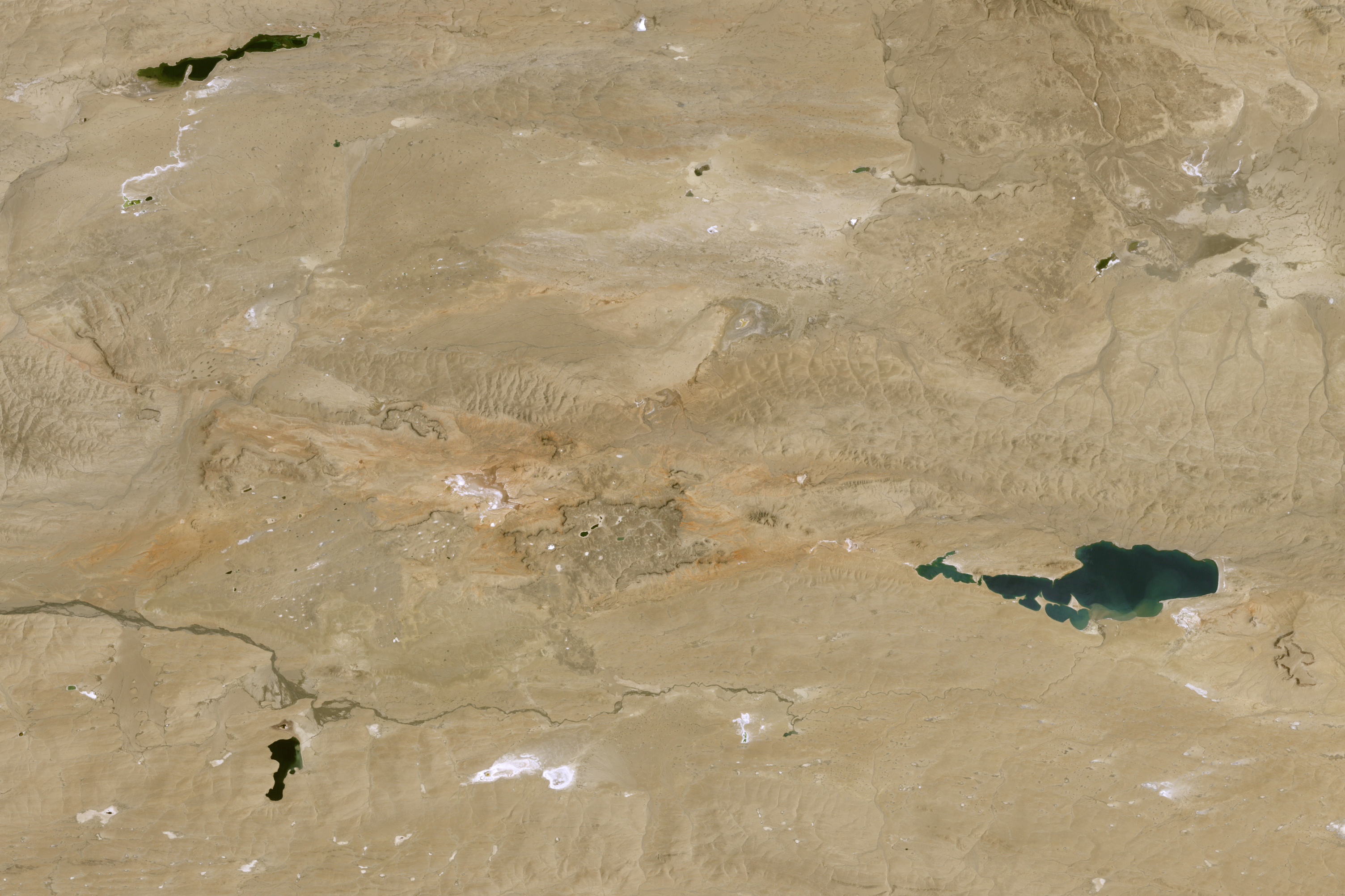
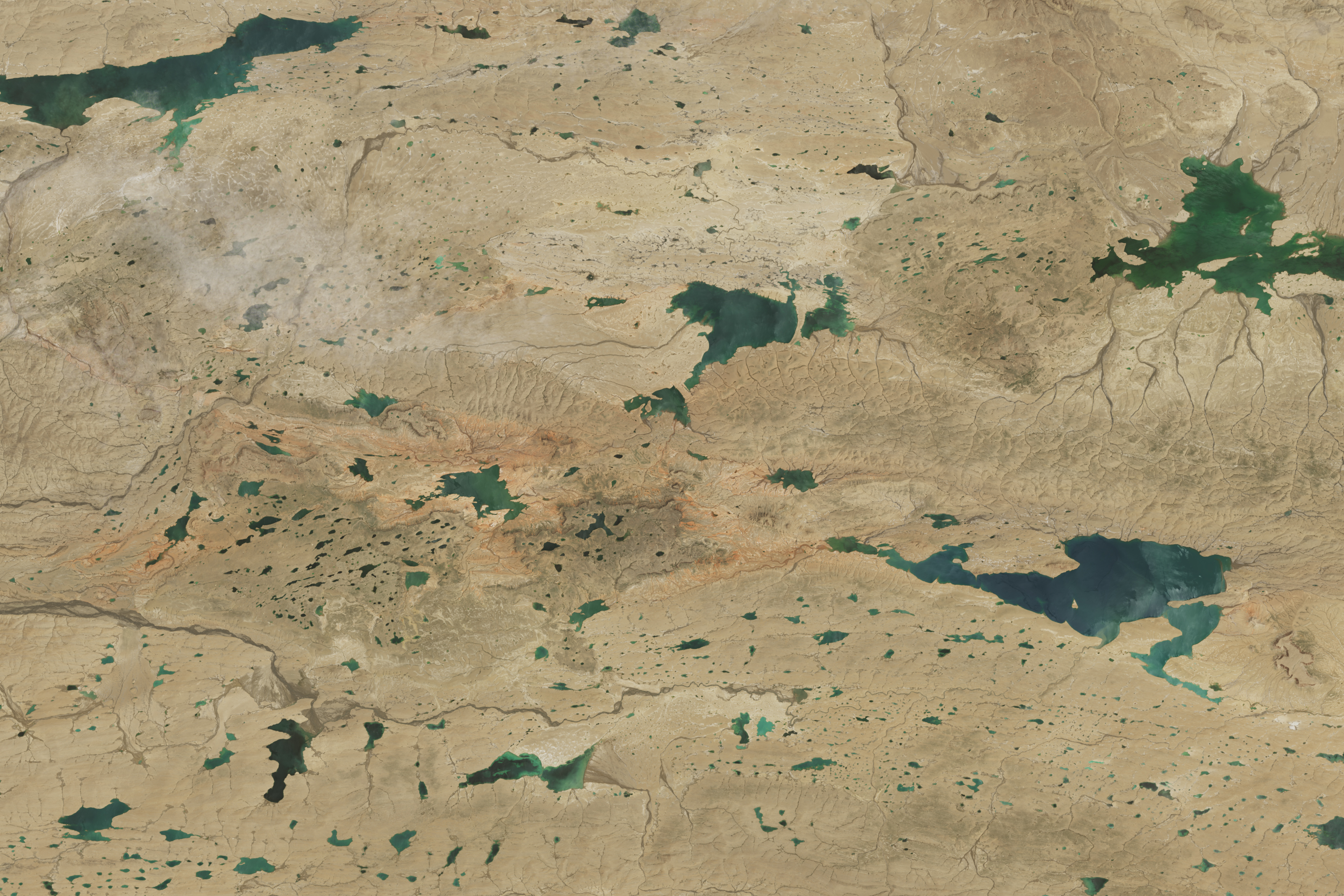
When researchers look to satellite data for insight into how the world’s lakes have fluctuated in recent decades, there’s one region that stands out for its rapid changes: the northern part of the Tibetan Plateau. While lakes in many parts of the world have lost water over the past three decades, the number and size of lakes in this part of the “roof of the world” have risen sharply.
The pair of images above shows changes to several lakes in Nyima and Qiemo counties, a landscape that encompasses mostly flat but highly elevated, arid grasslands in southwestern China’s Changtang region. The TM (Thematic Mapper) on Landsat 5 captured the left image on August 1, 1994. The OLI-2 (Operational Land Imager-2) on Landsat 9 captured the right image on August 11, 2024.
Landsat satellites have collected imagery of the Tibetan Plateau at least every 16 days since the 1970s, leaving scientists with a substantial trove of data to analyze. One global analysis based on Landsat observations and published in Science found that the northern part of the Tibetan Plateau encompassed some of the fastest-growing lakes in the world between 1992 and 2020.
In a study published in 2024 and focused specifically on the Tibetan Plateau, one group of researchers estimated that the plateau had a total of 4,385 lakes larger than 0.1 square kilometers in 1991, with 4.2 percent of them measuring between 10 and 50 square kilometers and 2.9 percent of them larger than 50 square kilometers. These lakes collectively covered 37,471 square kilometers, an area larger than Lake Erie. By 2023, the researchers counted more than 6,159 lakes covering 53,267 square kilometers of the plateau, an area nearly as large as Lake Michigan.
Lakes on the Tibetan Plateau are particularly prone to size variations because they mostly lie within endorheic basins, meaning water flows in but has no natural outlet. Factors such as precipitation levels, the rate of evaporation, and the intensity of seasonal thawing of frozen soils and melting of glacial ice thus play key roles in controlling the number and size of the plateau’s lakes.
Several regional analyses—including studies published in Scientific Reports, Journal of Hydrology, and Science of the Total Environment—focused on the lakes of the Tibetan Plateau. The decades of Landsat images analyzed in these studies showed major growth in lakes in the northern part of the plateau.
Some research teams pointed to increased precipitation as the primary driver of lake expansion in the region, while others cited rising air temperatures and the subsequent melting of glaciers and permafrost as important contributing factors as well.
Other researchers have looked at the current and anticipated effects of these expanding lakes. One team reported in Nature Geoscience that projected lake expansion by 2100 could lead to “widespread societal and ecological impacts,” noting that hundreds of kilometers of roads, hundreds of settlements, and 10,000 square kilometers of grasslands, wetlands, and croplands could be submerged.
“The dramatic increases in lake area are flooding people’s homes, displacing livestock, and making some glacial lakes vulnerable to outburst flooding,” said Fangfang Yao, a researcher at the University of Colorado Boulder and lead author of the study in Science. “The Tibetan Plateau is a very remote, harsh environment. Satellites like Landsat are the only way to observe changes across numerous lakes and long time periods.”
References
- Dou, X., et al. (2023) Spatio-Temporal Evolution of Glacial Lakes in the Tibetan Plateau over the Past 30 Years. Remote Sensing, 15(2), 416.
- Lei, Y., et al. (2023) Unprecedented lake expansion in 2017-2018 on the Tibetan Plateau: Processes and environmental impacts. Journal of Hydrology, 619,129333.
- Li, M., et al. (2022) Variation trends and attribution analysis of lakes in the Qiangtang Plateau, the Endorheic Basin of the Tibetan Plateau. Science of the Total Environment, 837, 155595.
- Liu, W., et al. (2021) Rapid expansion of lakes in the endorheic basin on the Qinghai-Tibet Plateau since 2000 and its potential drivers. CATENA, 197, 104942.
- Luo, J., et al. (2022) Abrupt increase in thermokarst lakes on the central Tibetan Plateau over the last 50 years. CATENA, 217, 106497.
- NASA Landsat Science. Accessed March 4, 2025.
- Wang, J., et al. (2022) Lake volume variation in the endorheic basin of the Tibetan Plateau from 1989 to 2019. Scientific Data, 9, 611.
- Xu, F., et al. (2024) Widespread societal and ecological impacts from projected Tibetan Plateau lake expansion. Nature Geoscience, 17, 516-523.
- Zhang, G., et al. (2021) 100 years of lake evolution over the Qinghai-Tibet Plateau. Earth System Science Data, 13, 3951-3971.
- Zhang, G., et al. (2021) Comprehensive estimation of lake volume changes on the Tibetan Plateau during 1976-2019 and basin-wide glacier contribution. Science of the Total Environment, 772, 145463.
- Zhang, G., et al. (2020) Response of Tibetan Plateau lakes to climate change: Trends, patterns, and mechanisms. Earth-Science Reviews, 208, 103269.
- Zhao, R., et al. (2022) Annual 30-m big Lake Maps of the Tibetan Plateau in 1991-2018. Scientific Data, 9, 1275.
- Zhou, G., et al. (2024) Accelerating thermokarst lake changes on the Qinghai–Tibetan Plateau. Scientific Reports, 611.
- Zhou, Y., et al. (2024) Annual improved maps to understand the complete evolution of 9 thousand lakes on the Tibetan Plateau in 1991-2023. ISPRS Journal of Photogrammetry and Remote Sensing, 217, 134-148.
NASA Earth Observatory images by Michala Garrison, using Landsat data from the U.S. Geological Survey. Story by Adam Voiland.
This image record originally appeared on the Earth Observatory. Click here to view the full, original record.