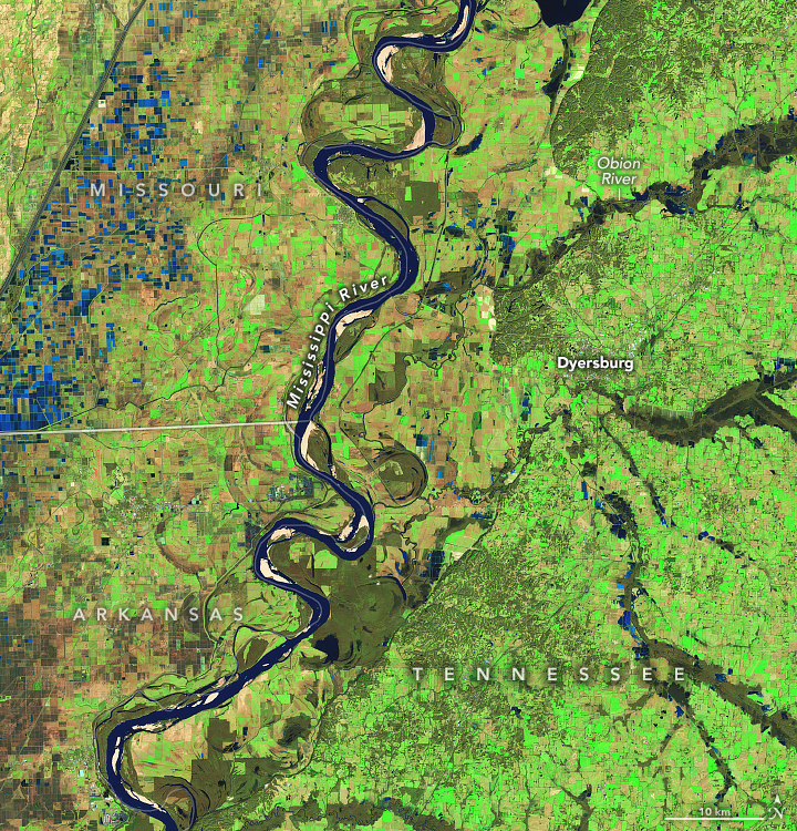

Floods Swamp Tennessee
Downloads
- tennflooding_oli_20250124_lrg.jpg (2691x2803, JPEG)
- tennflooding_oli2_20250217_lrg.jpg (2691x2803, JPEG)
Metadata
- Sensor(s):
- Landsat 8 - OLI
- Landsat 9 - OLI-2
- Data Date: January 24, 2025 - February 17, 2025
- Visualization Date: February 18, 2025
A powerful storm system moved across the U.S. Southeast on February 15-16, bringing damaging winds, torrential rains, and destructive flash floods to several communities in Tennessee and Kentucky.
Many areas received up to 6 inches (15 centimeters) of rain over a 48-hour period, according to the National Weather Service. Government data indicate that water levels in multiple rivers in the two states faced moderate to major flooding.
The OLI-2 (Operational Land Imager-2) on Landsat 9 captured this false-color image (right) of swollen rivers in western Tennessee on February 17, 2025. The image on the left shows the same area on January 24, 2025. The band combination (7-5-4) used in the images makes it easier to distinguish between water, land, and vegetation. Water appears lighter blue in the February 17 image because it is rich in suspended sediment. The water-covered fields in Missouri are rice fields.
In Tennessee, local authorities declared a state of emergency and ordered mandatory evacuations after a levee failed near Rives, a town along the Obion River with a population of about 250 people. More than half of the homes in the town suffered severe water damage, according to local news reports.
A U.S. Geological Survey water gauge at Obion, Tennessee, recorded a water level of 39.8 feet on February 18. Heights above 34 feet are considered flood stage. Officials in the nearby town of Dyersburg warned residents that evacuations may be necessary as water levels rose on the Forked Deer River.
Some of the most destructive flash flooding occurred north of these images, in western Kentucky. However, clouds on February 17 prevented satellites from acquiring similar images of floodwater in that area.
Meanwhile, forecasters are warning of new challenges for the region. A blast of frigid air is expected to pour into the region from the north, and a snowstorm from the west could drop several inches of snow on many of the same areas that flooded.
References
- AER (2025, February 10) Arctic Oscillation and Polar Vortex Analysis. Accessed February 18, 2025.
- Fox Weather (2025, February 17) Drone video provides dramatic look at flooding after levee fails in Tennessee. Accessed February 18, 2025.
- Kentucky Lantern (2025, February 17) Death toll rises to 14 after record rainfalls across Kentucky. Accessed February 18, 2025.
- NASA Earthdata Floods. Accessed February 18, 2025.
- National Water Prediction Service (2025, February 18) River Gauges. Accessed February 18, 2025.
- National Weather Service (2025, February 17) February 2025 Kentucky Flooding Summary. Accessed February 18, 2025.
- National Weather Service, via X (2025, February 16) The levee near Rives along the Obion River has failed. Accessed February 18, 2025.
- Rives Volunteer Fire Department, via Facebook (2025, February 16) Rives Volunteer Fire Department. Accessed February 18, 2025.
- U.S. Geological Survey (2025, February 18) Obion River at Hwy 51 Near Obion, TN—07026040. Accessed February 18, 2025.
- The Weather Channel (2025, February 16) At Least 9 Killed In Kentucky And Georgia As Floods, Severe Weather Slam South. Accessed February 18, 2025.
NASA Earth Observatory images by Michala Garrison, using Landsat data from the U.S. Geological Survey. Story by Adam Voiland.
This image record originally appeared on the Earth Observatory. Click here to view the full, original record.