Popocatépetl Continues to Grumble
Downloads
- popocatepetl_oli_20241025_lrg.jpg (4678x4548, JPEG)
Metadata
- Sensor(s):
- Landsat 8 - OLI
- Data Date: October 25, 2024
- Visualization Date: October 28, 2024
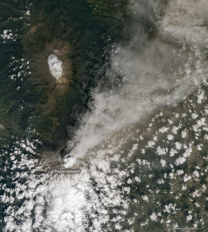
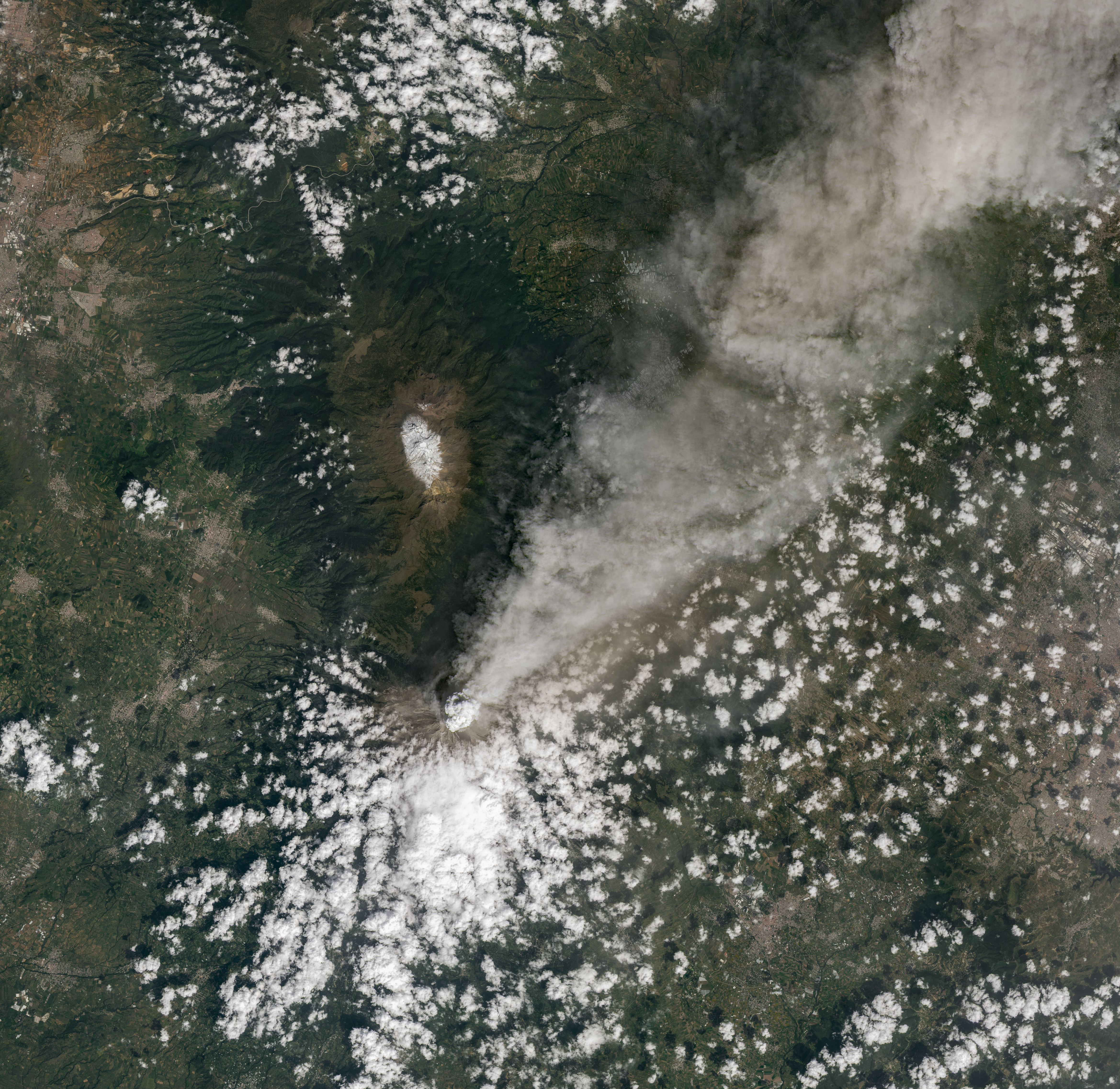
Popocatépetl, one of Mexico’s most active volcanoes, continued to spew gases and ash in October 2024. The towering mountain’s current period of activity, ongoing since 2005, has seen near daily episodes of seismic tremors and eruptions.
The OLI (Operational Land Imager) on Landsat 8 captured an image of one of the volcano’s recent eruptions on October 25, 2024. Monitoring systems on that day detected “a continuous emission of water vapor, volcanic gases, and ash,” according to Mexico’s Centro Nacional de Prevención de Desastres (CENAPRED).
During the week of October 16-22, CENAPRED reported ashfall in several communities near the volcano in central Mexico. Popocatépetl sits southeast of Mexico City and has around 30 million people living within a 70-kilometer (44-mile) radius of its summit. As of October 28, CENAPRED’s alert level remained at yellow (the middle level on a three-color scale), and the public was warned to stay at least 12 kilometers (8 miles) away from the crater.
Significant seismic tremors were detected on October 20 and were accompanied by a gas-and-ash plume that rose 2 kilometers (1.2 miles) above the crater. When volcanic ash—made of shards of glass and pulverized rock—falls, it can cause respiratory problems, contaminate drinking water, and harm livestock and crops.
Particles that stay high in the atmosphere are less of a concern for air quality, but they can travel large distances. Wind carried some of the ash over the Gulf of Mexico, and on October 26, the National Weather Service office in Jacksonville reported observations of ash high in the air above Sarasota, Florida. The weather service noted how these particles high in the atmosphere could cause colorful sunsets.
Popocatépetl has had recurring periods of activity since it rumbled to life in 1994 after 50 years of quiet. A research team estimated that the volcano has erupted explosively, with a Volcanic Explosivity Index (VEI) of at least 4, more than 25 times over the past 500,000 years, with the most recent one occurring about 1,100 years ago. The current eruption has a VEI of 2.
References & Resources
- Centro Nacional de Prevención de Desastres (CENAPRED) (2024, October 25) CENAPRED monitoring report on the Popocatépetl volcano. Accessed October 28, 2024.
- EOS (2024, January 29) How Dangerous Is Mexico’s Popocatépetl? It Depends on Who You Ask. Accessed January 30, 2024.
- NASA Earth Observatory (2024, January 31) Another Puff of Ash from Popocatépetl. Accessed October 28, 2024.
- National Weather Service, Jacksonville, via X (2024, October 26) Volcanic Ash high over Florida? Accessed October 28, 2024.
- Siebe, C., et al. (1996) Repeated volcanic disasters in Prehispanic time at Popocatépetl, central Mexico: Past key to the future? Geology, 24(5), 399-402.
- Smithsonian Global Volcanism Program (2024) Popocatépetl. Accessed October 28, 2024.
- Smithsonian Global Volcanism Program (2024) Report on Popocatepetl (Mexico) (Bennis, K L, and Sennert, S, eds.). Weekly Volcanic Activity Report, 16 October-22 October 2024. Accessed October 28, 2024.
- Sunyé-Puchol, I., et al. (2022) Reconstructing the middle to late Pleistocene explosive eruption histories of Popocatépetl, Iztaccíhuatl and Tláloc-Telapón volcanoes in Central México. Journal of Volcanology and Geothermal Research, 421, 107413.
NASA Earth Observatory image by Michala Garrison, using Landsat data from the U.S. Geological Survey. Story by Emily Cassidy.
This image record originally appeared on the Earth Observatory. Click here to view the full, original record.