Streaming Snow and “Sea Smoke”
Downloads
- seasmoke_oli_20241010_lrg.jpg (4233x2822, JPEG)
- seasmokezm_oli_20241010_lrg.jpg (1088x725, JPEG)
Metadata
- Sensor(s):
- Landsat 8 - OLI
- Data Date: October 10, 2024
- Visualization Date: October 25, 2024
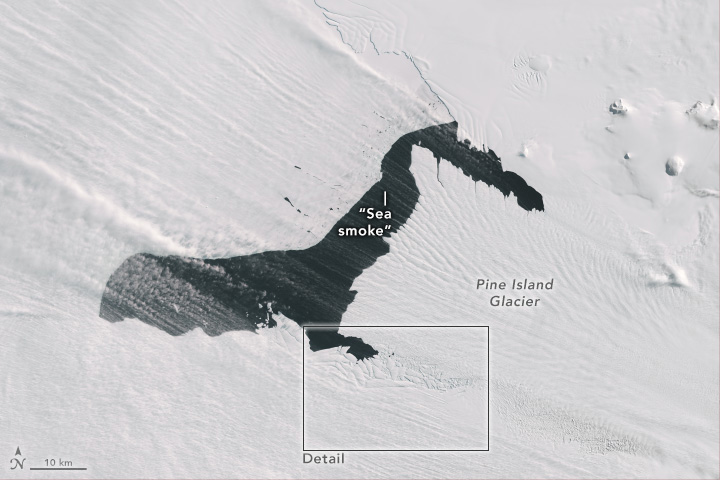
Pine Island Glacier, along with neighboring Thwaites Glacier, garners attention as one of the main pathways for ice flowing from the West Antarctic Ice Sheet to the Amundsen Sea. It has also been one of the fastest-retreating glaciers in Antarctica, and ice on its seaward edge regularly fractures and calves off icebergs—some large enough to be named. In October 2024, however, it was the atmosphere above the ice that stole the show with a display of blowing snow and “sea smoke.”
Satellites are usually unable to capture clear images of these near-surface atmospheric phenomena because clouds tend to be present when they occur, said Christopher Shuman, a University of Maryland, Baltimore County, glaciologist based at NASA’s Goddard Space Flight Center. This was not the case on October 10, 2024, when the OLI (Operational Land Imager) on Landsat 8 acquired this image. It illustrates “the power of the wind,” in this case racing out to the edges of the continent from the cold interior, he said.
In this image, “sea smoke” appears to form at the very edge of the glacier’s terminus, as well as over open water along its northern edge, Shuman said. This phenomenon occurs because of a stark difference in temperature between the ice and the water surrounding it. Here, winds are pushing water and sea ice away from the ice front, driving an upwelling of relatively warm water to replace it from below. Sea smoke forms when cold air moves across the warmer water, and when the cold air cannot hold the water vapor it encounters, it quickly condenses into small ice crystals.
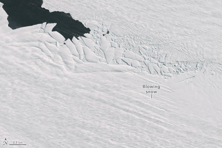
The wind is also kicking up snow from the surface of the adjacent West Antarctic Ice Sheet, accounting for more streams of white across the scene. The origins of some of these plumes are particularly visible near the jumbled shear zone along the south side of Pine Island Glacier, shown in the detailed image below.
The two phenomena seen here are a testament to the strength of springtime winds over Antarctica. “One really shouldn’t be surprised to see winds coming out of the interior with all the cold winter air that’s been isolated there for months,” Shuman said. The ice sheet’s mass of cold air sets the stage for katabatic winds, which develop when that relatively cold, dense air flows downslope and rushes out toward the coast.
In parts of Antarctica, including the area around Pine Island Glacier, strong winds can transport and sublimate enough snow to have significant influence on the surface mass balance of polar ice sheets. However, the extent to which blowing snow contributes to the loss of surface mass is not fully understood due to the difficulty of collecting ground-based data at these sites and gaps in satellite observations.
References
- American Museum of Natural History Katabatic Winds. Accessed October 25, 2024.
- Gerber, F. et al. (2023) CRYOWRF—Model Evaluation and the Effect of Blowing Snow on the Antarctic Surface Mass Balance. Journal of Geophysical Research: Atmospheres, 128(12), e2022JD037744.
- NASA Earth Observatory (2019, April 9) The Wide View of a Shrinking Glacier: Retreat at Pine Island. Accessed October 25, 2024.
- NASA Earth Observatory (2020, February 14) Pine Island Glacier’s Newest Iceberg. Accessed October 25, 2024.
NASA Earth Observatory images by Wanmei Liang, using Landsat data from the U.S. Geological Survey. Story by Lindsey Doermann.
This image record originally appeared on the Earth Observatory. Click here to view the full, original record.
