A is for Azerbaijan
Downloads
- azerbaijan_oli2_20240902_lrg.jpg (1676x1117, JPEG)
- earth.jpg (720x480, JPEG)
- azerbaijanwide_oli2_20240902_lrg.jpg (2350x2611, JPEG)
Metadata
- Sensor(s):
- Landsat 9 - OLI-2
- Landsat 8 - OLI
- Data Date: September 2, 2024
- Visualization Date: September 24, 2024
Today’s story is the answer to the September 2024 puzzler.
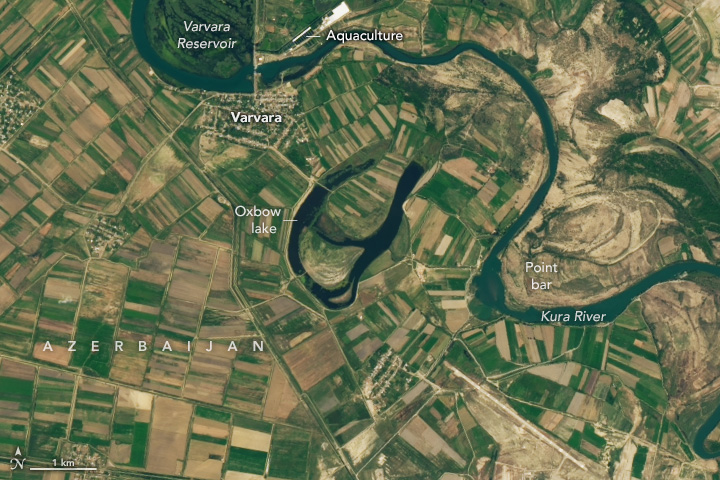
The headwaters of the Kura River, Azerbaijan’s longest waterway, lie in the mountains of northeastern Türkiye. From there, the Kura winds through the forested hills and valleys of the Lesser Caucuses before turning east and heading toward Tbilisi, Georgia’s capital. The river continues westward into Azerbaijan and drains eventually into the Mingachevir and Varvara reservoirs, which were built by the former Union of Soviet Socialist Republics in the 1940s and 1950s, respectively.
Suspended sediment, silty banks, and a shallow downstream gradient encourage growth of the winding, snake-like curves and bends in the river known as meanders. Water flowing through these bends tends to be deeper and flow more quickly along the outer edge, where it carves a cutbank, while shallower, slower-moving water deposits a point bar along the inner edge. Over time, the bends can become so sharp and elongated that the river loops back onto itself and cuts the meander off, forming a separate U-shaped (or C-shaped) body of water called an oxbow lake.
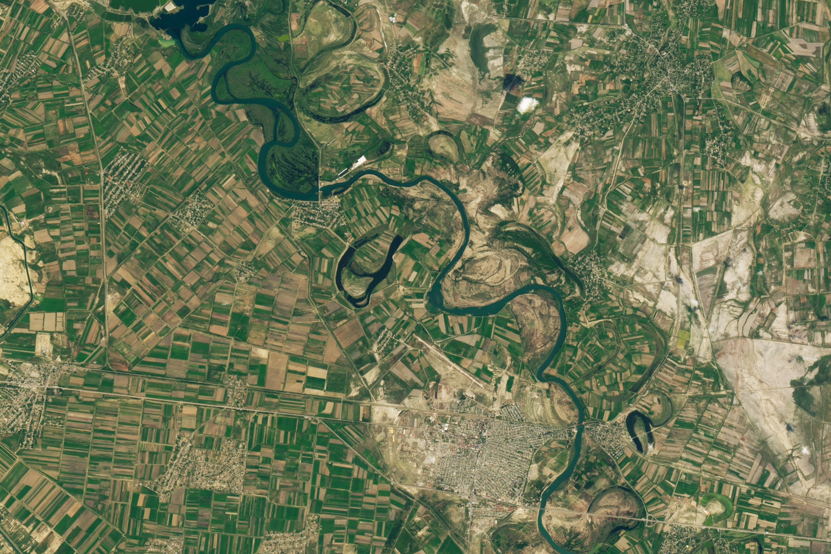
These erosional processes formed the curvy, A-shaped lake shown above. The A’s cross-hatch likely formed before the lake separated from the main river channel. As the bend elongated, the river likely formed a new, more direct channel bisecting the bend. The OLI-2 (Operational Land Imager) on Landsat 9 acquired this image on September 2, 2024. The image below shows a broader view of the same area.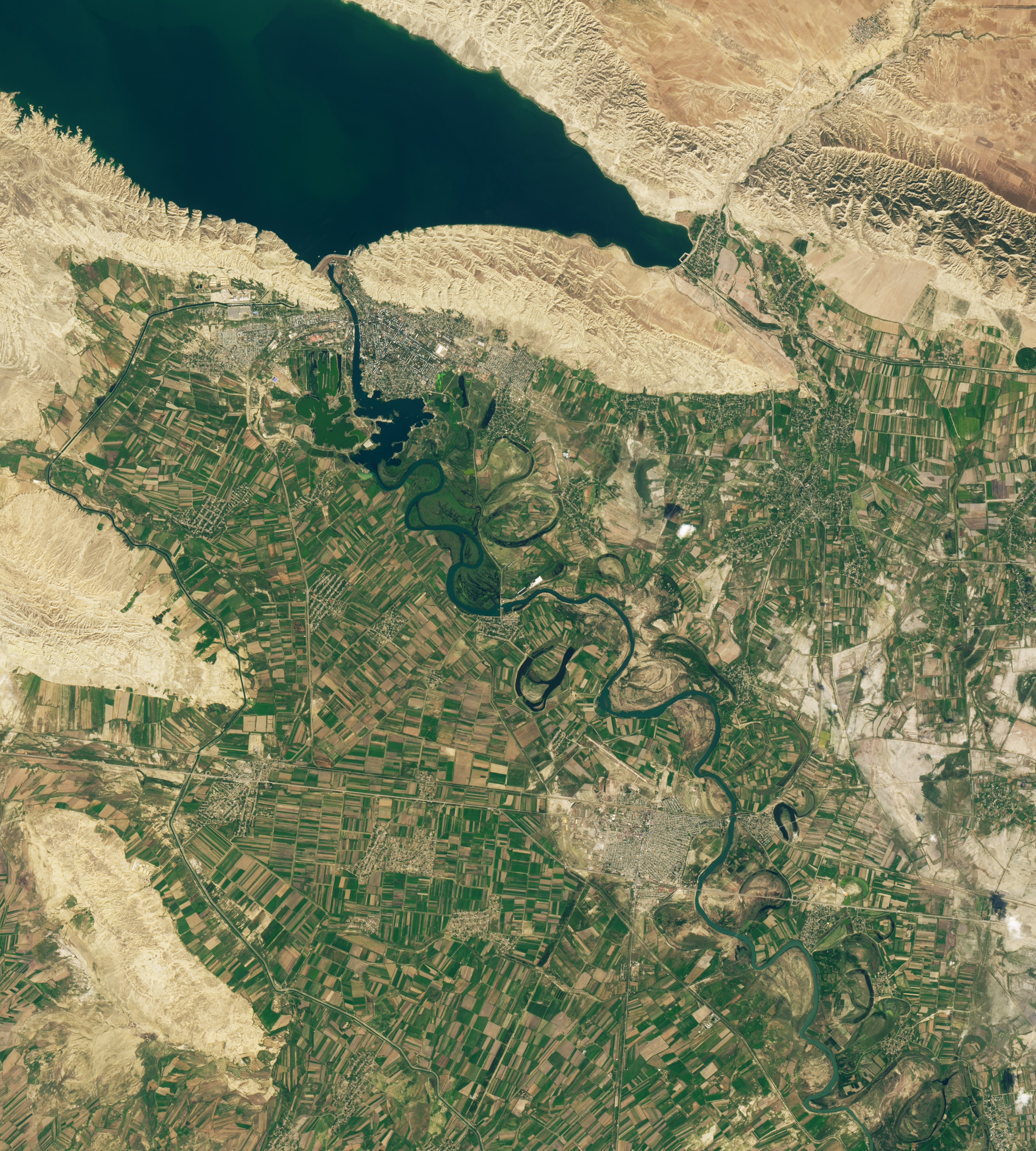
That A-shaped lake, known locally as Ozero Akhmaz, is one of several oxbow lakes flanking the main channel of the river. These isolated features typically display darker blue water because they contain less suspended sediment than the main channel of the river.
While natural processes often form meanders and oxbow lakes, human activity has also transformed the landscape. In addition to dams, a network of canals runs through the scene on both sides of the river, conveying water to farmland and towns. This irrigation system makes it easier to grow a variety of crops, including cotton, barley, millet, wheat, sunflowers, fruits, and vegetables, in the region’s cold, semi-arid climate.
Industry including textiles, manufacturing, and mining are also present, particularly in and around Mingachevir, a growing city that is now the fourth-largest city in Azerbaijan. Fishing and intensive use of the river have reduced the number of species that live in the Kura, but there are efforts to replenish some species. The fish farm visible on the north bank of the river (top image), for instance, raises sturgeon and herring to bolster populations of these prized animals.
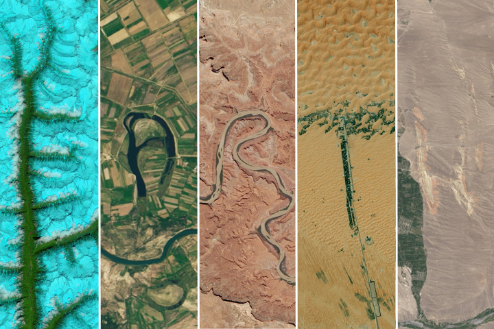
Lake Akhmaz is one of dozens of letter-shaped features on Earth’s surface curated by NASA’s Landsat outreach team. The images are part of an interactive tool that allows users to compose names or other words using Landsat images of Earth. For more information about some of the letters, see Earth Observatory’s 2012 Reading the ABCs from Space story.
References
- The Fish Site (2024, April 22) Putting Azerbaijan back on the global caviar map. Accessed September 24, 2024.
- Ministry of Ecology and Natural Resources of the Republic of Azerbaijan (2024) National Ecosystem Assessment. Accessed September 24, 2024.
- Nagel, N.W., et al., (2023) The use of satellite remote sensing for exploring river meander migration. Earth-Science Reviews, 104607.
- NASA Earth Observatory (2015, December 15) Reading the ABCs from Space. Accessed September 24, 2024.
- NASA Earth Observatory (2014, December 4) Meandering in the Amazon. Accessed September 24, 2024.
- NASA Earth Observatory (2017, October 15) Connecticut River Oxbow. Accessed September 24, 2024.
- NASA Landsat Science (2024) Your Name in Landsat Interactive. Accessed September 24, 2024.
- National Park Service (2023) Fluvial Features—Meandering Stream. Accessed September 24, 2024.
- Pueppke, S. G.,et al., (2023) Re-Establishing Naturally Reproducing Sturgeon Populations in the Caspian Basin: A Wicked Problem in the Ural River. Accessed September 24, 2024.
- USDA Foreign Agricultural Service (2024) Commodity Explorer. Accessed September 24, 2024.
NASA Earth Observatory images by Wanmei Liang, using Landsat data from the U.S. Geological Survey. Story by Adam Voiland.
This image record originally appeared on the Earth Observatory. Click here to view the full, original record.