Constructing Egypt’s New Capital
Downloads
- cairos_newcaptial_oli_20170814_lrg.jpg (1632x1587, JPEG)
- cairos_newcaptial_oli2_20240809_lrg.jpg (1632x1587, JPEG)
- cairos_newcapital_anim.mp4 (MPEG)
Metadata
- Sensor(s):
- Landsat 8 - OLI
- Landsat 9 - OLI-2
- Landsat 5 - TM
- Data Date: August 14, 2017 - August 9, 2024
- Visualization Date: August 22, 2024
Renowned for its grand architecture, cultural heritage, and religious sites, Cairo has a rich history extending back to the 10th century C.E. The city’s long run as Egypt’s capital, however, is coming to a close. As has happened many times in the country’s past, the seat of the national government is moving, this time to a brand-new city in the desert 45 kilometers (28 miles) east of Cairo.
Considering Cairo’s rising population, congestion, and pollution, the government announced in 2015 that it would build and migrate to the so-called New Administrative Capital (the city is not yet officially named). In 2024, more than 22 million people were estimated to live in Cairo, with a population density of more than 19,000 people per square kilometer. The new city will ultimately cover an area about the size of Singapore. It is designed to house more than six million residents, along with Egyptian government offices, a financial district, and other facilities.
As of March 2024, more than 1,500 families had moved to the city, according to news reports, with that number expected to reach 10,000 by the end of the year. Government ministries were relocating, the parliament began meeting in its new building, and several banks and businesses were slated to move their headquarters there.
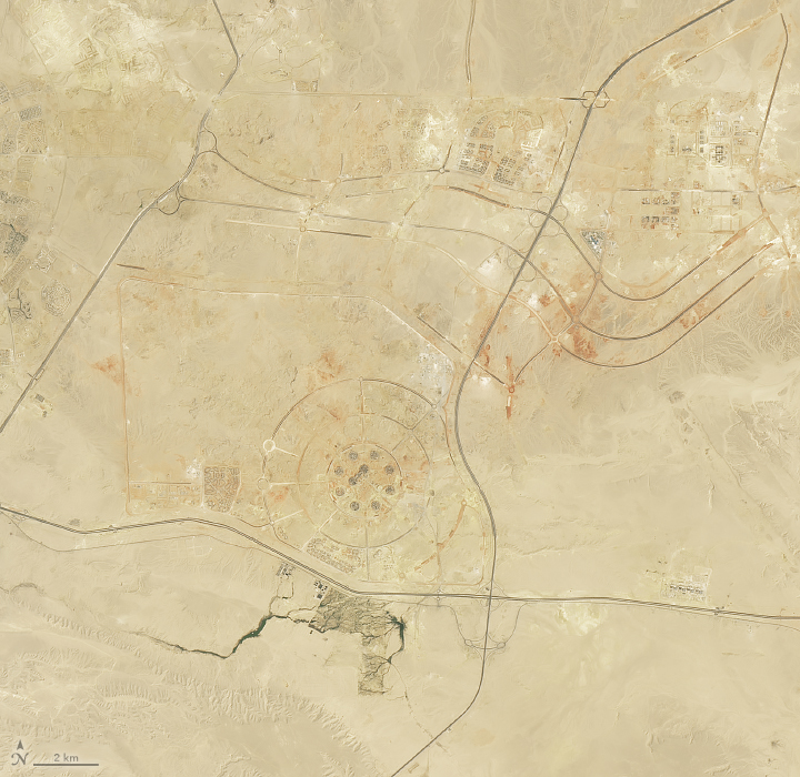
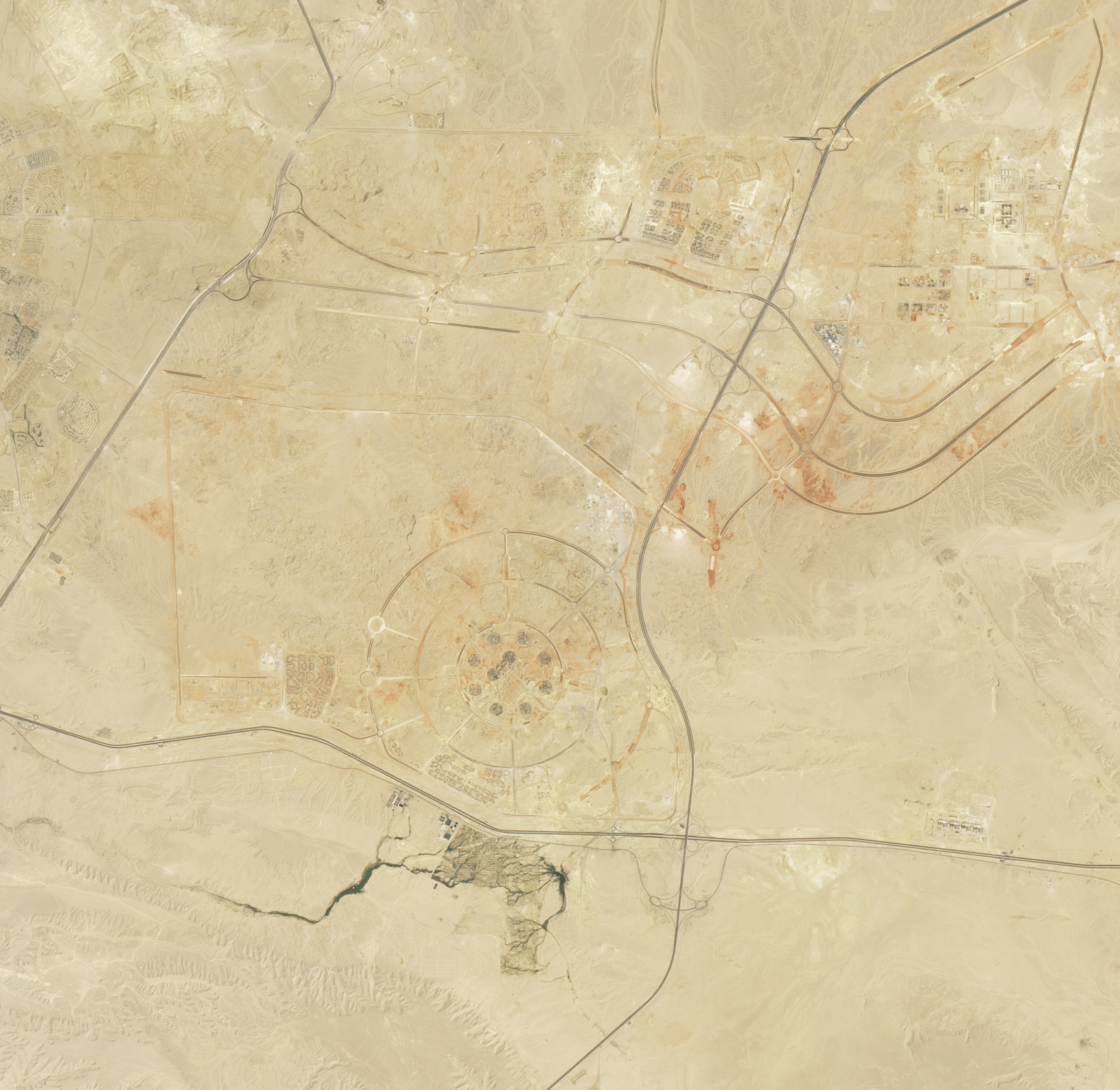
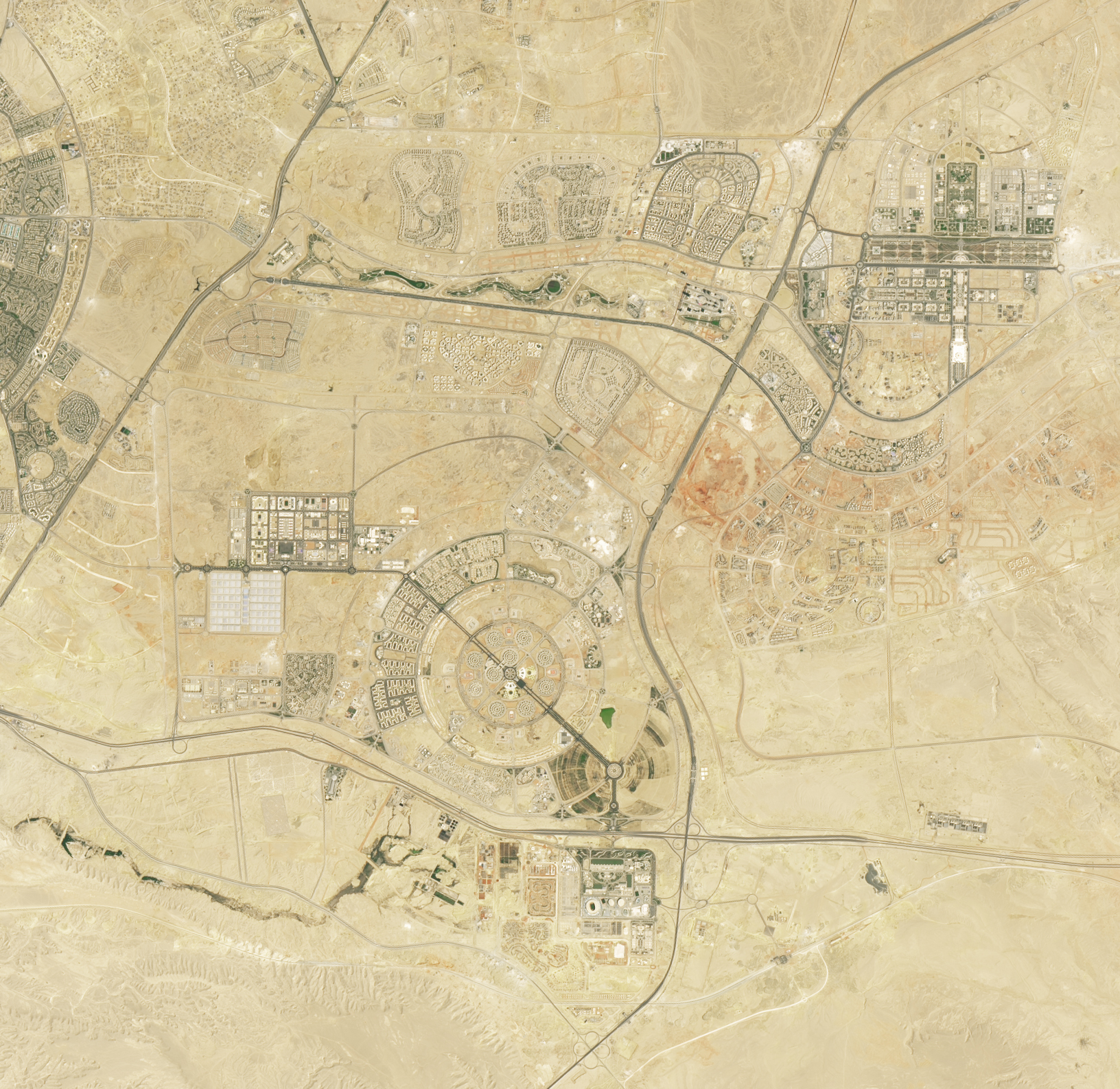
These images of the new capital were acquired by the OLI (Operational Land Imager) on Landsat 8 (left) and the OLI-2 on Landsat 9 in August 2017 (left) and August 2024 (right), respectively. In the earlier image, traces of the city are visible; work on the megaproject had begun by this time. The expansion of the New Administrative Capital is evident in the later image.
Several large landmarks in the new capital are easily visible in the images. Sinuous green space, part of Green River Park, stretches for 10 kilometers through the arid landscape, containing walking and biking paths and native Egyptian vegetation. Many government ministry offices comprise the dense development to the east of the park, while the Ministry of Defense occupies a sizeable facility called The Octagon (despite its concentric-circle appearance in this image). To the south, a sports complex contains the second-largest stadium in Africa and many other sports facilities. Egypt is reportedly planning a bid to host the Olympics.
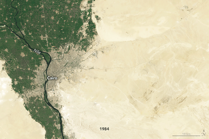
Cairo, one of Africa’s largest cities, has undergone profound expansion for decades. Its urban growth has been documented from space since 1965 and NASA’s Gemini 5 mission. In more recent years, Landsat satellites have imaged Cairo’s expansion and the construction of other new, outlying cities. The time series above shows how the greater Cairo area changed every 10 years between 1984 and 2024.
Cairo’s population has grown from about 8 million to over 22 million since 1984, and this near-tripling of the population has dramatically changed the city’s footprint. In addition to building upward and outward along the fertile floodplain of the Nile River, development has spread to several new satellite cities built on desert plains outside of the city. Approximately 95 percent of Egypt’s population lives within 20 kilometers of the Nile River and its delta, reliant on its fertile land and water. With increasing domestic and agricultural demands, the country is likely to import more water than is supplied by the Nile by the end of this decade, according to one projection.
References
- The Atlantic (2023, August 30) Egypt’s New Capital-City Megaproject. Accessed August 23, 2024.
- CNN (2024, March 20) A new city is rising in Egypt. But is it what the country needs? Accessed August 23, 2024.
- NASA Earth Observatory (2020, April 2) New Ground for an Ancient City. Accessed August 23, 2024.
- NASA Earth Observatory (2001, September 16) Urban Growth in Cairo 1965-98. Accessed August 23, 2024.
- Nikiel, C.A., and Eltahir, E.A.B. (2021) Past and future trends of Egypt’s water consumption and its sources. Nature Communications, 12, 4508.
- UNESCO World Heritage Convention Historic Cairo. Accessed August 23, 2024.
NASA Earth Observatory images by Michala Garrison, using Landsat data from the U.S. Geological Survey. Story by Lindsey Doermann.
This image record originally appeared on the Earth Observatory. Click here to view the full, original record.