
Wildfire Scorches Eastern Oregon
Downloads
- oregonfire_oli_20240712_lrg.jpg (1420x1479, JPEG)
- oregonfire_oli2_20240713_lrg.jpg (1420x1479, JPEG)
Metadata
- Sensor(s):
- Landsat 8 - OLI
- Landsat 9 - OLI-2
- Data Date: July 12, 2024 - July 13, 2024
- Visualization Date: July 15, 2024
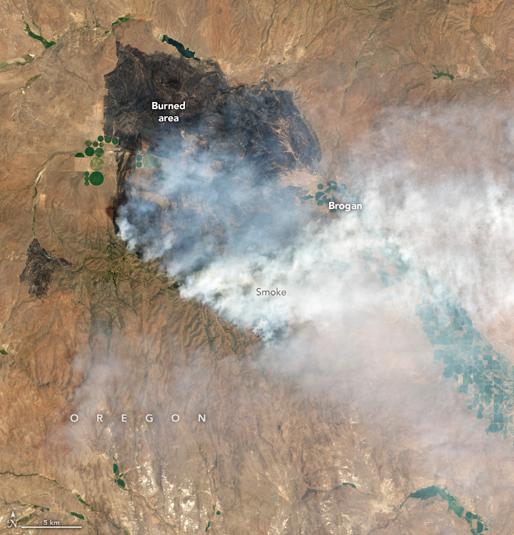
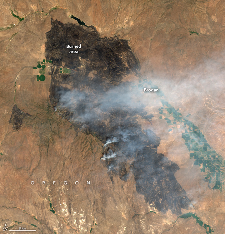
During record-breaking heat, multiple wildland fires raged across Oregon in mid-July 2024. The Cow Valley fire, the largest in the state, had burned over 132,000 acres (526 square kilometers) as of July 15.
The fire ignited on the morning of July 11 in an area of open rangeland near Brogan, a small town in eastern Oregon. Blistering heat, low humidity, and high winds allowed the fire to spread quickly to the south. Smoke billowed from the fire as it burned through dry grasses and shrubs.
The images above show the growth of the burned area (darker surfaces) between July 12 (left) and July 13 (right). On the evening of July 12, the fast-moving blaze had burned over 80,000 acres, according to officials. By the morning of July 13, it had burned over 114,000 acres. The images were captured by the OLI (Operational Land Imager) aboard the Landsat 8 satellite and the OLI-2 on Landsat 9, respectively.
The fire coincided with a long-lasting heat dome that brought extreme temperatures to much of the U.S. West. On July 10, Baker City, Oregon, 40 miles north of Brogan, hit 105 degrees Fahrenheit (40 degrees Celsius), breaking the record of 99°F for that day set in 2002, according to the National Weather Service (NWS). The nearby airport in Boise, Idaho, endured five consecutive days of heat that reached at least 105°F, exceeding the previous record of four days in a row set in July 2002. The NWS began keeping records in 1875.
On July 15, much of the growth of the fire was on the western edge, according to the Oregon State Fire Marshal, and firefighters were working to contain it.
References & Resources
- CBS 2, Idaho News (2024, July 14) Fire crews battle 114,000-acre Cow Valley Fire amid severe weather, zero containment. Accessed July 15, 2024.
- Fox 12, Oregon (2024, July 12) Cow Valley Fire burns through over 20k acres overnight in east Oregon. Accessed July 15, 2024.
- InciWeb (2024, July 15) Orvad Cow Valley Fire Information. Accessed July 15, 2024.
- NASA Earth Observatory (2024, July 15) Extreme Heat Hammers U.S. Coasts. Accessed July 15, 2024.
- National Interagency Fire Center (2024, July 15) Cow Valley Fire Update for Monday, July 15, 2024. Accessed July 15, 2024.
- National Weather Service, Boise, via X (2024, July 13) Boise Airport has officially hit 106 degrees today, which brings the consecutive days of max temperatures of 105 degrees or greater to 5 days. Accessed July 15, 2024.
- U.S. Bureau of Land Management, via Facebook (2024, July 12) Cow Valley Fire Update for Friday, July 12. Accessed July 15, 2024.
NASA Earth Observatory images by Wanmei Liang, using Landsat data from the U.S. Geological Survey. Story by Emily Cassidy.
This image record originally appeared on the Earth Observatory. Click here to view the full, original record.