Home Reef Volcano Grows
Downloads
- homereef_oli2_20240615_lrg.jpg (4234x2823, JPEG)
Metadata
- Sensor(s):
- Landsat 9 - OLI-2
- Data Date: June 15, 2024
- Visualization Date: June 28, 2024
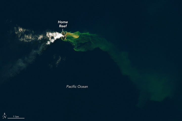
Dry land is ephemeral at Home Reef, a mid-ocean volcano in the central Tonga islands. Cycles of eruptions and erosion have periodically created and destroyed a small island there since at least the mid-19th century. In June 2024, an eruption tacked on new area to the speck of land, lofted a volcanic plume into the sky, and discolored the surrounding seawater.
Volcanic activity at Home Reef is on display in this image, acquired by the OLI-2 (Operational Land Imager-2) on Landsat 9 on June 15, 2024. On that day, lava flowed from a vent on the island, according to Tonga Geological Services, expanding the land that emerged in a September 2022 eruption and causing the coastline to bulge out to the east.
As a cloud of volcanic emissions streamed west, a plume of discolored water flowed east and south, its lighter color contrasting with the blue seawater. Previous research has shown such plumes of superheated, acidic water can contain particulate matter, volcanic rock fragments, and sulfur, as well as precipitates of silicon, iron, and aluminum oxides. At other submarine volcanoes, scientists have detected a change in water color via satellite imagery up to one month before an eruption, suggesting that ocean color could presage a potentially destructive event.
Home Reef sits within the Tonga-Kermadec subduction zone, an area where three tectonic plates are colliding at the fastest converging boundary in the world. Here, the Pacific Plate is sinking beneath two other small plates, yielding one of Earth’s deepest trenches and most active volcanic arcs.
The first recorded eruption at Home Reef dates to 1852, with another potential island-forming eruption occurring in 1857, according to the Smithsonian Institution Global Volcanism Program. The volcano reawakened in 1984 and 2006, both times creating small new islands and sending pumice “rafts”—concentrated patches of porous, lightweight volcanic rock—drifting across the ocean surface.
No floating patch of stone was apparent around Home Reef in June 2024. Nonetheless, ships were advised to stay at least 4 kilometers (2.5 miles) away from the island. The volcanic activity posed low risk to communities on the nearby Vava’u and Ha’apai island groups, according to Tonga Geological Services. The agency was also reporting satellite-detected thermal anomalies at the volcano through at least June 27.
References
- NASA Earth Observatory New Island and Pumice Raft, Tonga. Accessed June 27, 2024.
- PreventionWeb (2022, January 21) Underwater volcanoes: How ocean colour changes can signal an imminent eruption. Accessed June 27, 2024.
- Sakuno, Y. (2021) Trial of Chemical Composition Estimation Related to Submarine Volcano Activity Using Discolored Seawater Color Data Obtained from GCOM-C SGLI. A Case Study of Nishinoshima Island, Japan, in 2020. Water, 13(8), 1100.
- Smithsonian Institution Global Volcanism Program Home Reef. Accessed June 27, 2024.
- Tonga Geological Services (2024) Tonga Geological Services, Government of Tonga. Accessed June 27, 2024.
NASA Earth Observatory image by Lauren Dauphin, using Landsat data from the U.S. Geological Survey. Story by Lindsey Doermann.
This image record originally appeared on the Earth Observatory. Click here to view the full, original record.