Orce’s Archaeological Wonderland
Downloads
- orcespain_oli2_20240223_lrg.jpg (1522x1015, JPEG)
Metadata
- Sensor(s):
- Landsat 9 - OLI-2
- Data Date: February 23, 2024
- Visualization Date: March 20, 2024
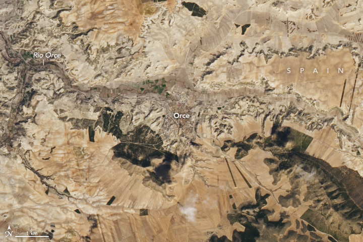
The village of Orce is situated on the high plateau of Granada in southern Spain. Residents have long relied on groundwater to raise crops or livestock in the region’s semi-arid landscapes. Many still do, but in 1976 a farmer east of town unearthed some unusual fossilized bones in a field near the Rio Orce that helped turn the town into a destination for archaeological research.
Once archaeologists began digging, they discovered that calcareous muds formed in ponds near the shores of an ancient lake had preserved vast troves of fossils. Among them: a child’s tooth that was 1.4 million years old. According to some experts, that meant the fossils in this area represented some of the oldest examples of hominins in western Europe. Other fossils discovered in this area include saber-toothed tigers, hyenas, hippos, horses, deer, bovids, mammoths, rhinoceroses, wild dogs, and wolves.
The location of that first discovery, as well as several nearby fossil sites that archaeologists have excavated, are within the area shown in the wide view of this satellite image. The image was captured by the OLI-2 (Operational Land Imager) on Landsat 9 on February 23, 2024.
While satellites and remote sensing did not play a direct role in locating the fossils discovered in this area, these technologies have helped advance the field of archaeology in recent decades. Read more about that in Peering through the Sands of Time: Searching for the Origins of Space Archaeology.
References
- Alba, D. (2022) A fistful of fossils: The rise and fall of the Orce Man and the politics of paleoanthropological science. Journal of Human Evolution, 165, 103166.
- BBC (2023, November 15) Orce, Spain: The site of Europe’s earliest settlers. Accessed April 22, 2024.
- Espigares, M., et al. (2019) The earliest cut marks of Europe: a discussion on hominin subsistence patterns in the Orce sites (Baza basin, SE Spain). Scientific Reports, 9.
- Orce (2024) Los Yacimientos. Accessed April 22, 2024.
- Sanchez-Bandera, C., et al. (2020) New stratigraphically constrained palaeoenvironmental reconstructions for the first human settlement in Western Europe: The Early Pleistocene herpetofaunal assemblages from Barranco León and Fuente Nueva 3 (Granada, SE Spain). Quaternary Science Reviews, 243, 1.
- Toro-Moyano, I., et al. (2013) The oldest human fossil in Europe, from Orce (Spain). Journal of Human Evolution, 65(1), 1-9.
- Universidad de Granada Cuenca de Orce y Solana del Zamborino. Accessed April 22, 2024.
NASA Earth Observatory image by Wanmei Liang, using Landsat data from the U.S. Geological Survey. Story by Adam Voiland.
This image record originally appeared on the Earth Observatory. Click here to view the full, original record.