Costa Atlántica Reserve
Downloads
- costaatlantica_reserve_oli2_20240220_lrg.jpg (2673x3341, JPEG)
Metadata
- Sensor(s):
- Landsat 9 - OLI-2
- Data Date: February 20, 2024
- Visualization Date: March 12, 2024
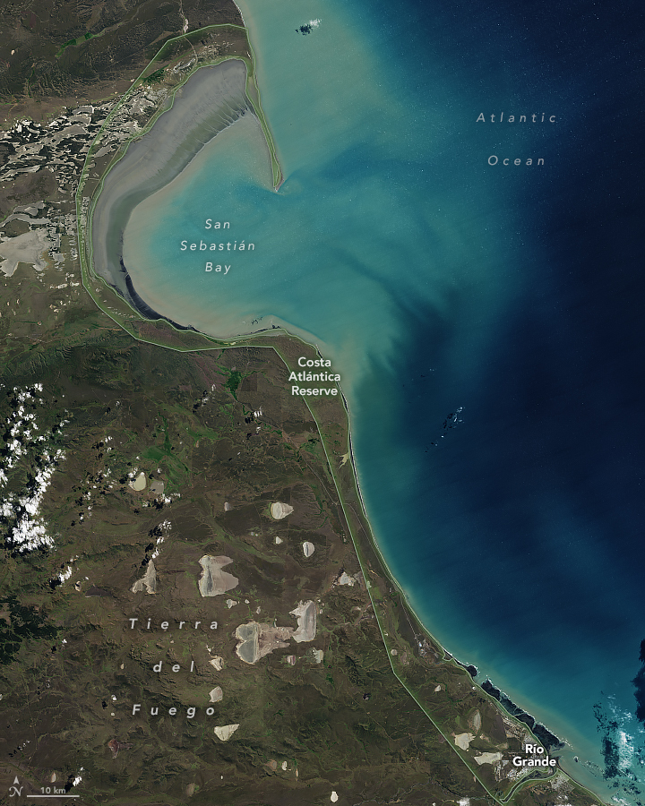
At the far southern reaches of South America, a stretch of tidal flats, shoals, and beaches serves as a refuge for migratory shorebirds and copious aquatic life. The Costa Atlántica Reserve in Argentina extends for 220 kilometers (140 miles) along the eastern shore of Tierra del Fuego. The area was designated a Ramsar site in 1995 and a provincial nature reserve in 1998. It is the southernmost site both on the Ramsar list and in the Western Hemisphere Shorebird Reserve Network.
The OLI-2 (Operational Land Imager-2) on Landsat 9 captured this view of the reserve on February 20, 2024. Tidal habitats along the coast support some 135 species of birds, while crustaceans, mollusks, fish, and cetaceans feed in the productive coastal waters. The topography inland of Costa Atlántica, stretching into Chile to the west, is blanketed in shrubs and grassland vegetation adapted to dry conditions—part of a semiarid ecosystem known as the Fuegian steppe.
The broader landscape of the Tierra del Fuego archipelago was shaped by glaciers. Ice advanced over the mountains and lowlands during cold climatic periods between the mid-Pleistocene, about 1 million years ago, and the Last Glacial Maximum, about 20,000 years ago. San Sebastián Bay formed in a tectonic depression that was deepened by glacial erosion. Further evidence of glaciation, including hummocky moraines and fields of glacial erratics, appears around the bay, though it is too small to be visible in this image.
Partially enclosed by a long, sandy peninsula, San Sebastián Bay attracts copious migratory birds, some of which shuttle seasonally between the Northern and Southern Hemispheres. Large populations of the Hudsonian godwit, white-rumped sandpiper, and other long-distance flyers congregate in the vast intertidal zones. This part of the reserve, however, is vulnerable to the impact of oil and gas extraction from onshore and offshore deposits.
The coast south of the bay, around the city of Río Grande, is an important area for the red knot, a shorebird that migrates between southern Argentina and the Canadian Arctic. One particular red knot, “B95,” that was banded near Río Grande in February 1995, achieved fame (and its own biography) for its migratory prowess. B95 earned the nickname “Moonbird” because it is estimated to have flown the distance of the Earth to the Moon and halfway back—a total of approximately 577,000 kilometers (360,000 miles)—during its exceptionally long life.
References
- Balocchi, L.D., et al. (2020) Geomorphology of the northeastern extreme of Isla Grande de Tierra del Fuego, Argentina. Journal of Maps, 16:2, 512-523.
- Coronato, A., et al. (2021) Glacial Landforms as Geodiversity Resources for Geotourism in Tierra del Fuego, Argentina. Quaestiones Geographicae, 41, 5-24.
- Hoose, P. (2012) Moonbird: A Year on the Wind with the Great Survivor B95. Accessed July 10, 2024.
- Ramsar Sites Information Service (1995) Reserva Costa Atlantica de Tierra del Fuego. Accessed July 10, 2024.
- Western Hemisphere Shorebird Reserve Network Costa Atlántica de Tierra del Fuego. Accessed July 10, 2024.
NASA Earth Observatory image by Michala Garrison, using Landsat data from the U.S. Geological Survey. Story by Lindsey Doermann.
This image record originally appeared on the Earth Observatory. Click here to view the full, original record.