Escaping Home
Downloads
- harriettubman_park_oli2_20240122_lrg.jpg (2363x1969, JPEG)
- tubman_pho_master-pnp-ppmsca-54200-54230a_lrg copy.jpg (3615x2410, JPEG)
Metadata
- Sensor(s):
- Landsat 9 - OLI-2
- Data Date: January 22, 2024
- Visualization Date: February 16, 2024
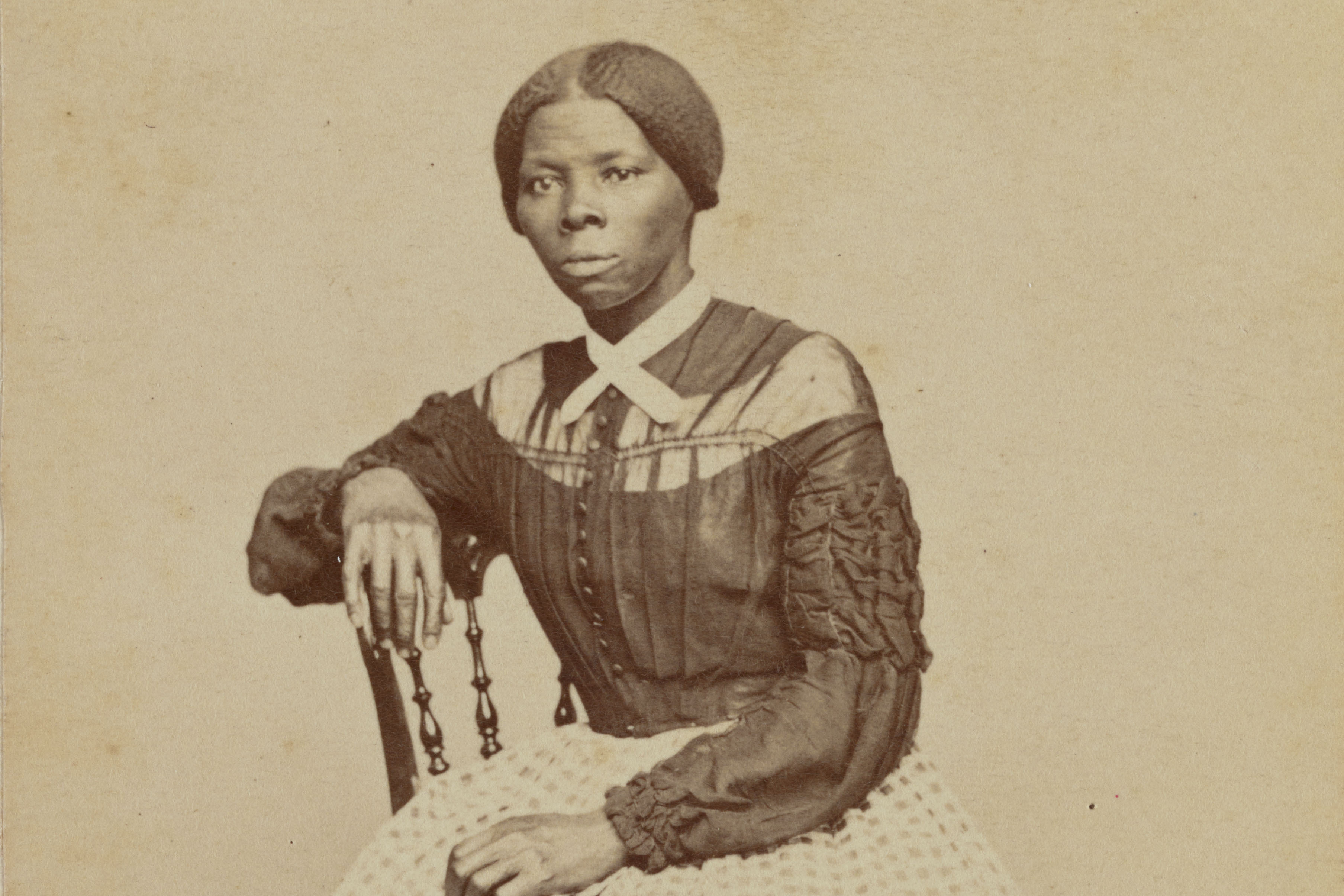
As early as the age of six, Araminta “Minty” Ross—who later changed her name to Harriet Tubman—spent long hours slogging through the muck of the Little Blackwater River in Dorchester County, Maryland, to check on muskrat traps for the people who had enslaved her. It was frigid, challenging work, often done barefoot and in the fall or winter when muskrats grow their plushest pelts.
The survival, navigation, and foraging skills she began honing on those winter outings would later prove useful when she escaped her captors in 1849 and fled to Pennsylvania. She tested her skills again when she returned to the Eastern Shore of Maryland several times over the span of a decade to smuggle her parents, brothers, friends, and dozens of other enslaved people out of the region as a conductor on the Underground Railroad, and then again as a scout, spy, and military commander during the Civil War. Her remarkable record of liberating enslaved people—more than 70 people from Maryland and 700 during a military raid on Combahee Ferry in South Carolina—ultimately earned her national prominence and the nickname “the Moses of her people.”
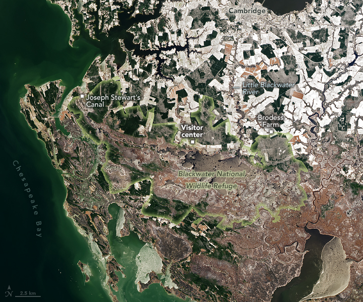
On January 22, 2024, the OLI-2 (Operational Land Imager-2) on Landsat 9 acquired this wintry scene of the network of rivers, marshes, canals, and ponds in Dorchester County that Tubman grew up around and later navigated in the pursuit of freedom. The image includes Brodess Farm, where she lived and worked as a child, and Joseph Stewart’s Canal, where she helped cut and transport timber. Just east of Brodess Farm is Bucktown General Store, where an altercation with a local slave owner resulted in Tubman being struck in the head by an iron weight that led to lifelong seizures. While her childhood home is gone, the visitor center for the Harriet Tubman Underground Railroad National Historical Park, established in 2014, now stands nearby.
Tubman escaped from bondage on the Eastern Shore in the fall of 1849 when she was 27. Guided by the stars and driven by faith, she made her way more than 90 miles (145 kilometers) north by following a route that brought her through marshes, canals, and rural churches and Quaker meeting houses on the Eastern Shore, into Delaware, and eventually to Philadelphia.
After making her escape, Tubman returned to the Eastern Shore of Maryland at least 13 times. “I was the conductor of the Underground Railroad for eight years, and I can say what most conductors can’t say: ‘I never ran my train off the track, and I never lost a passenger,’” Tubman once said. She typically helped enslaved people escape during the winter because the long, dark nights afforded more cover and made it easier to elude slave catchers. It was also easier to navigate marshy areas when the ground was frozen compared to the warmer months when silty areas turned to muck.
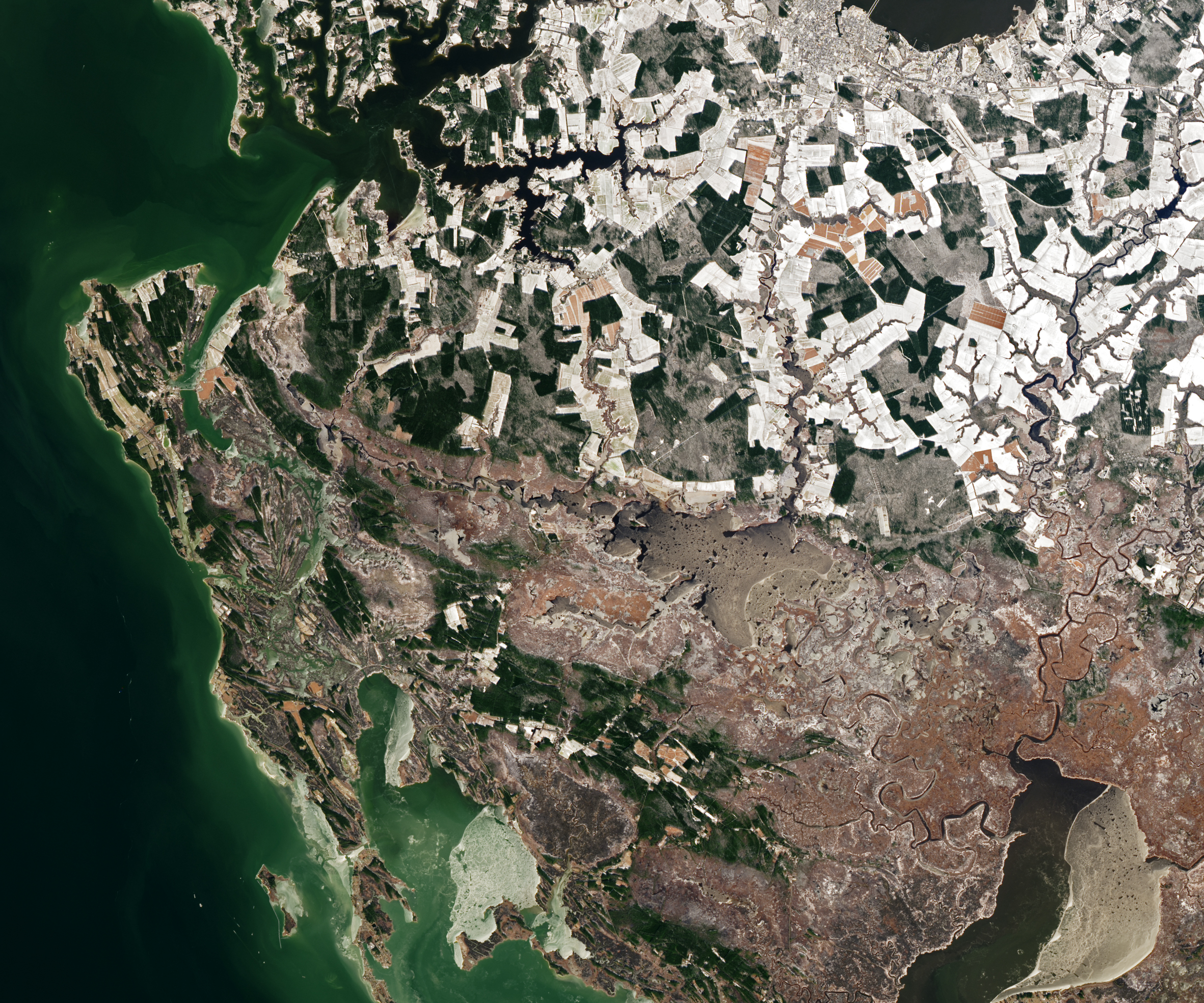
The modern-day landscapes of Dorchester County and the Harriet Tubman Underground Railroad National Historical Park would be mostly familiar to Tubman. Outside of some urban development around Cambridge and other towns, much of the land remains open farmland, forest, and wetlands. Oak and loblolly pine forests and reedy marshes still fringe much of the area’s farmland. But there are some notable differences. Many farms that raised a mixture of crops and animals in Tubman’s time are now used to raise just soybeans and sorghum crops.
The most striking changes relate to the water level. In a region where local sea levels are rising and the landscape is sinking at among the fastest rates on the East Coast, many waterways in Dorchester County—especially around Blackwater National Wildlife Refuge—are significantly deeper and wider than what Tubman would have experienced. She would also likely notice marked shifts in the locations of marshes and forests, as well as an expansion of dead “ghost forests” caused by intrusions of salt water.
Given the rate of sea level rise, some news organizations and nonprofit organizations have pointed out that flooding will likely affect the park’s land in the future. NASA’s sea level rise projection tool indicates that sea levels in this area could rise by between 0.6 and 1 meter by 2100. An analysis by Climate Central suggests that sea level rise on that scale could chronically flood several key sites in the park, including the Brodess Farm and Joseph Stewart’s Canal.
References
- AccuWeather Weather played a crucial role for the Underground Railroad. Accessed February 16, 2024.
- Bay Journal (2021, November 23) ‘Virtually Unaltered’: Harriet Tubman’s Eastern Shore. Accessed February 16, 2024.
- Climate Central (2021) Future Flood Risk: Harriet Tubman Underground Railroad Byway. Accessed February 16, 2024.
- Harriet Tubman Underground Railroad Byway Interactive Map. Accessed February 16, 2024.
- Library of Congress (2020, June 16) Harriet Tubman: Conductor on the Underground Railroad. Accessed February 16, 2024.
- PBS Harriet Tubman: Visions of Freedom. Accessed February 16, 2024. ?
- Maryland (2022, November 20) Harriet Tubman: The Ultimate Outdoorswoman. Accessed February 16, 2024.
- Maryland Matters (2021, October 11) Chronic Flooding Threatens Sites Along Harriet Tubman Underground Railroad Byway. Accessed February 16, 2024.
- National Museum of African American History & Culture (2022, March 4) Harriet Tubman. Accessed February 16, 2024.
- National Parks Conservation Association (2022, May 20) Losing Sites on the Trail to Freedom. Accessed February 16, 2024.
- National Park Service (2024) Harriet Tubman. Accessed February 16, 2024.
- National Women’s History Museum (2024) Harriet Tubman. Accessed February 16, 2024
- NOAA (2015, January 14) The Future of Maryland’s Blackwater Marsh. Accessed February 16, 2024.
- The Baltimore Banner (2023, February 27) Commentary: What catching muskrats as a child taught Harriet Tubman. Accessed February 16, 2024.
- The Dirt (2022, October 18) The Landscapes of Harriet Tubman. Accessed February 16, 2024.
- The New York Times (2022, June 21) Finding Traces of Harriet Tubman on Maryland’s Eastern Shore. Accessed February 16, 2024.
NASA Earth Observatory image by Michala Garrison, using GIS data from the U.S. Fish and Wildlife Service and Landsat data from the U.S. Geological Survey. Harriet Tubman photograph by Benjamin Powelson, courtesy of the Library of Congress. Story by Adam Voiland.
This image record originally appeared on the Earth Observatory. Click here to view the full, original record.